国立情報学研究所 - ディジタル・シルクロード・プロジェクト
| |||||||||
|
| On Ancient Central-Asian Tracks : vol.1 | |
| 中央アジア踏査記 : vol.1 |
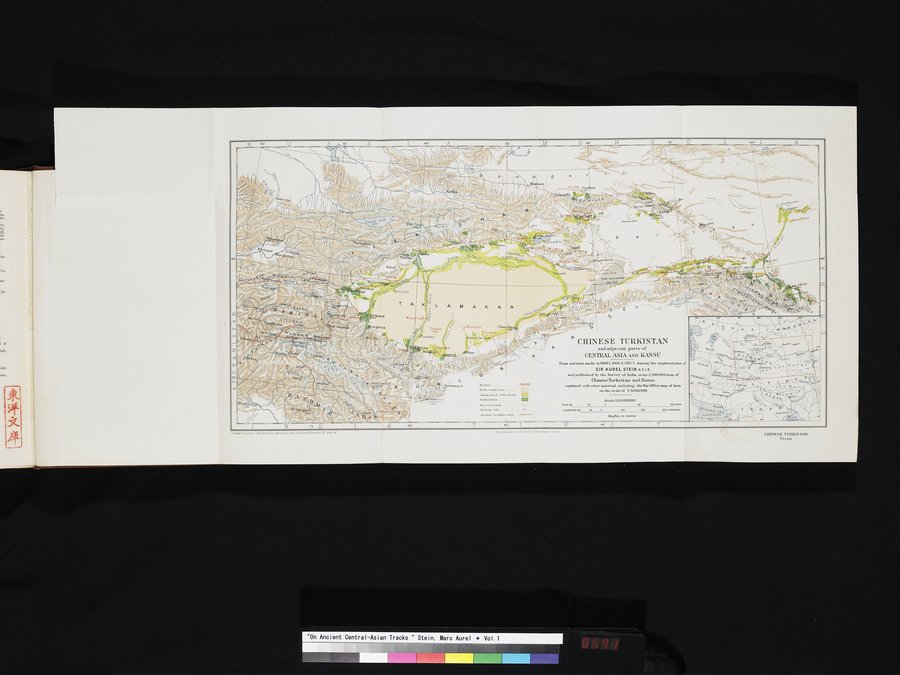 |
| 中国領トルキスタンと中央アジアの隣接部および甘粛。1900-1年,1906-8年, 1913-5年のオーレル・スタイン卿(インド帝国勲章上級爵士)による探検中に作成された測量図,およびその中国領トルキスタンと甘粛の1/500,000の地図中でインド測量局から公刊されたもの。なおこれは1/4,000,000のアジア陸軍省地図を含む他の資料と組み合わされている。CHINEZE TURKISTAN and adjacent parts of CENTRAL ASIA AND KANSU From surveys made in 1900-1,1906-8, 1913-5 during the explorations of SIR AUREL STEIN, K. C. I. E. and published by the Survey of India in his 1/500,000 map of Chinese Turkistan and Kansu combined with other material, including the War Office map of Asia on the scale of 1/4,000,000 |
eo A es M 0 ao N G es' 0 L wti I
Ah•ae.kö)
y6.' =!v•~
y,~nSito Sva-tonrusnd
ChBLtdd.
Qi
F
U
~. ben
'.,., n 5,4
D
Routes
Drin -.,md area. . Sank: tr,vl with smut.... -
tultiwatintt. -
Dry riverbed.
Aneiettt. one .. ... C.
Aneienl. 11•onner.enli. .~.~ •
N CHINESE TIIRKISTAN
and adjacent parts of
CENTRAL ASIA KANSU
Prom surveys umde m78001.1906`8,1813•S during the erploratioos of
SIR AUREL STEIN,K.c.I.E.
andpublishedbythe Survey of India inbis 1/500,000map of
ChineseTurkistan and ransu.
combined with other materiel, including the Wm' Office map of Amin
on the scale of 1/4000,000
Scale 1/6.000,000
na.erus~ao ie....9 140 mo aaoKno.etnts
Mighte in mover
a0• T as'
91)•
Conned A e.r,r,,wW tYrvrla.a Mondtau and Blauland. Atnürl. a6 and 44• 9epwwta•of Ne &i Gn'on,fJ,t'ptl. Saeir
C1UNESE TURKISTAN
Stein
|
Copyright (C) 2003-2019
National Institute of Informatics(国立情報学研究所)
and
The Toyo Bunko(東洋文庫). All Rights Reserved.
本ウェブサイトに掲載するデジタル文化資源の無断転載は固くお断りいたします。