国立情報学研究所 - ディジタル・シルクロード・プロジェクト
| |||||||||
|
| Cathay and the Way Thither : vol.1 | |
| 中国および中国への道 : vol.1 |
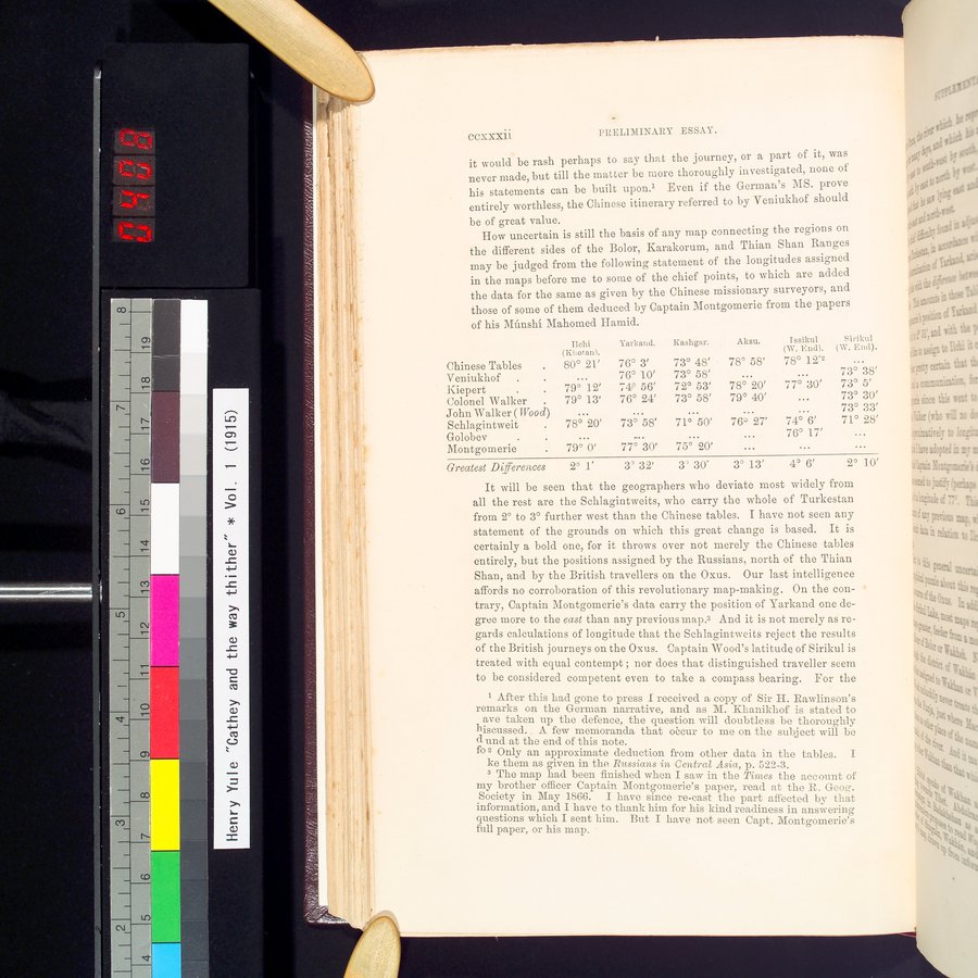 |
CCXXXii PRELIMINARY ESSAY.
it would be rash perhaps to say that the journey, or a part of it, was never made, but till the matter be more thoroughly investigated, none of his statements can be built upon.' Even if the German's MS. prove entirely worthless, the Chinese itinerary referred to by Veniukhof should
be of great value.
How uncertain is still the basis of any map connecting the regions on
the different sides of the Bolor, Karakorum, and Thian Shan Ranges may be judged from the following statement of the longitudes assigned in the maps before me to some of the chief points, to which are added the data for the same as given by the Chinese missionary surveyors, and those of some of them deduced by Captain Montgomerie from the papers of his Mûnshi Mahomed Hamid.
|
| Ilchi | Yarkand. | Kashgar. | Aksu. | Tssikul | Sirikul | ||||
| Chinese Tables | 80° 21' | 76° | 3' | 73° 48' | 78° | 58' | 78° | 12'2 | ... |
|
| Veniukhof . | ... | 76° | 10' | 73° 58' | ... |
| ... |
| 73° | 38' |
| Kiepert • . | 79° 12' | 74° | 56' | 72° 53' | 78° | 20' | 77° | 30' | 73° | 5' |
| Colonel Walker | 79° 13' | 76° | 24' | 73° 58' | 79° | 40' | ... |
| 73° | 30' |
| John Walker ( Wood) | ... |
| ... | ... |
| ... | ... |
| 73° | 33' |
| Schlagintweit • | 78° 20' | 73° | 58' | 71° 50' | 76° | 27' | 74° | 6' | 71° | 28' |
| Golobev | ... |
| .... | ... |
| ... | 76° | 17' | ... |
|
| Montgomerie . | 79° 0' | 77° | 30' | 75° 20' |
| ... |
| ... | ... |
|
| Greatest Differences | 2° 1' | 3' | 32' | 3' 30' | 3° | 13' | 4° | 6' | 2° | 10' |
It will be seen that the geographers who deviate most widely from all the rest are the Schlagintweits, who carry the whole of Turkestan from 2° to 3° further west than the Chinese tables. I have not seen any statement of the grounds on which this great change is based. It is certainly a bold one, for it throws over not merely the Chinese tables entirely, but the positions assigned by the Russians, north of the Thian Shan, and by the British travellers on the Oxus. Our last intelligence affords no corroboration of this revolutionary map-making. On the contrary, Captain Montgomerie's data carry the position of Yarkand one degree more to the east than any previous map.3 And it is not merely as regards calculations of longitude that the Schlagintweits reject the results of the British journeys on the Oxus. Captain Wood's latitude of Sirikul is treated with equal contempt ; nor does that distinguished traveller seem to be considered competent even to take a compass bearing. For the
After this had gone to press I received a copy of Sir H. Rawlinson's
remarks on the German narrative, and as M. Khanikhof is stated to
ave taken up the defence, the question will doubtless be thoroughly
hiscussed. A few memoranda that oècur to me on the subject will be d and at the end of this note.
fo 2 Only an approximate deduction from other data in the tables. I ke them as given in the Russians in Central Asia, p. 522-3.
3 The map had been finished when I saw in the Times the account of my brother officer Captain Montgomerie's paper, read at the R. Geocr.
Society in May 1866. I have since re-cast the part affected by that information, and I have to thank him for his kind readiness in answering
questions which I sent him. But I have not seen Capt. Montgomerie's full paper, or his map.
|
Copyright (C) 2003-2019
National Institute of Informatics(国立情報学研究所)
and
The Toyo Bunko(東洋文庫). All Rights Reserved.
本ウェブサイトに掲載するデジタル文化資源の無断転載は固くお断りいたします。