国立情報学研究所 - ディジタル・シルクロード・プロジェクト
| |||||||||
|
| Innermost Asia : vol.1 | |
| 極奥アジア : vol.1 |
 |
| 双城子付近にある要塞の遺跡の概略図ROUGH SKETCH PLAN OF RUINED FORT NEAR SHUANG-CH'ĒNG-TZÜ |
410 FROM SU-CHOU TO THE LIMES OF MAO-MEI [Chap. XII
that gate against inroads, or as an advanced base for offensive movements against nomadic hosts. The line followed by the Limes along the lowest course of the Pei-ta-ho convinced me that the Maomei area must have been included in the great border defence scheme of the Han epoch from the very time, between 12I and 115 B. c., when the territories of Su-chou and Kan-chou were first wrested from Hun domination and organized into Chinese border commands.2 I was therefore particularly interested to see as much of the Mao-mei oasis as the time available would allow, and to visit whatever ancient remains might be discovered within or near it.
March along Through inquiries made by our Mongol, who had a way of getting round the secretiveness
eastern all too common with the honest folk of these Kan-su marches, I learned that a ruined town to which
portion of local tradition ascribed great antiquity was to be found towards the lower end of that main portion of
oasis. ~ g ~ q Y P
the oasis which stretches along the right bank of the united river course. Accordingly on May 15th, instead of at once regaining the left bank where the continuation of the Limes was likely to be found above the narrow strip of cultivation skirting the river on that side, I proceeded by the road leading through the broadest portion of the oasis towards Shuang-ch`êng-tzti and the site reported
near it. The belt of cultivation was continuous for the first six miles or so from the town ; but hemmed in on the east by a bare gravel Sai and on the west by the broad sandy bed of the river, it nowhere exceeded three miles in width.
Farther on, scrub-covered patches of gravel intermingled with fields, until after ten miles we again reached well-tilled
ground at the pleasant village of Shuang-ch`êng-tzti, where camp was pitched.
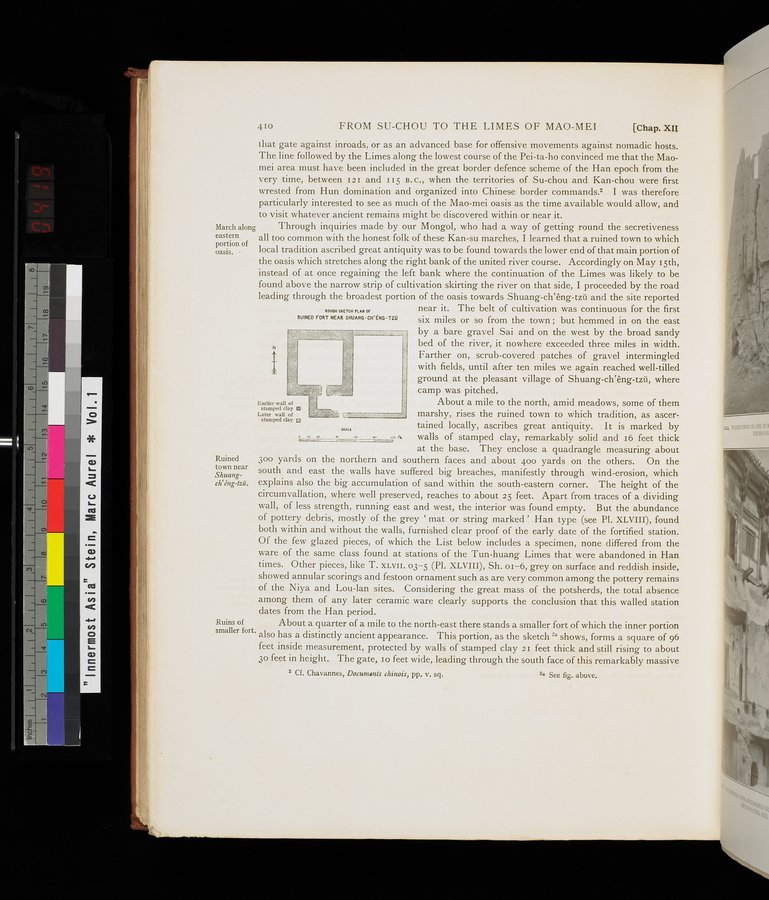
lEarlie w clay ®l lay 0 About a mile to the north, amid meadows, some of them
Later Wall of ,p r ,iri OW/ marshy, rises the ruined town to which tradition, as ascer-
stamped clay cttained locally, ascribes great antiquity. It is marked by
ct. walls of stamped clay, remarkably solid and 16 feet thick
at the base. They enclose a quadrangle measuring about
Ruined 30o yards on the northern and southern faces and about 400 yards on the others. On the
town near south and east the walls have suffered big breaches, manifestly through wind-erosion, which Shuang-
ch`êng-tzti. explains also the big accumulation of sand within the south-eastern corner. The height of the circulnvallation, where well preserved, reaches to about 25 feet. Apart from traces of a dividing wall, of less strength, running east and west, the interior was found empty. But the abundance of pottery debris, mostly of the grey ` mat or string marked ' Han type (see Pl. XLVIII), found both within and without the walls, furnished clear proof of the early date of the fortified station. Of the few glazed pieces, of which the List below includes a specimen, none differed from the ware of the same class found at stations of the Tun-huang Limes that were abandoned in Han times. Other pieces, like T. XLVII. 03-5 (Pl. XLVIII), Sh. o1-6, grey on surface and reddish inside, showed annular scorings and festoon ornament such as are very common among the pottery remains of the Niya and Lou-lan sites. Considering the great mass of the potsherds, the total absence among them of any later ceramic ware clearly supports the conclusion that this walled station dates from the Han period.
Ruins of About a quarter of a mile to the north-east there stands a smaller fort of which the inner portion
smaller fort. also has a distinctly ancient appearance. This portion, as the sketch '`a shows, forms a square of 96
feet inside measurement, protected by walls of stamped clay 21 feet thick and still rising to about
3o feet in height. The gate, 10 feet wide, leading through the south face of this remarkably massive
2 Cf. Chavannes, Documents chinois, pp. v. sq. 2a See fig. above.
ROUGH SKETCH PLAN OF
RUINED FORT NEAR SHUANG•CFI'ÉNG•TZÜ
SCALE
|
Copyright (C) 2003-2019
National Institute of Informatics(国立情報学研究所)
and
The Toyo Bunko(東洋文庫). All Rights Reserved.
本ウェブサイトに掲載するデジタル文化資源の無断転載は固くお断りいたします。