国立情報学研究所 - ディジタル・シルクロード・プロジェクト
| |||||||||
|
| Explorations in Turkestan : Expedition of 1904 : vol.1 | |
| トルキスタンの調査 1904年 : vol.1 |
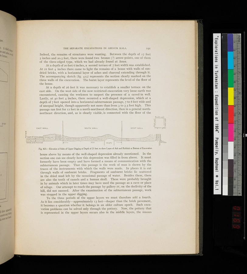 |
| 21フィートの深さにおける上層発掘現場の断層の立面図。発掘現場の底部に灰や廃物の層があることが示されているElevation of Slides of Upper Digging at Depth of 21 feet, to show Layer of Ash and Rubbish at Bottom of Excavation. |
THE SEPARATE EXCAVATIONS IN GHIAUR KALA. 191
Indeed, the remains of structures were wanting. Between the depth of 17 feet 5 inches and 20.5 feet, there were found two bronze (?) arrow-points, one of them of the three-edged type, which we had already found at Anau.
At a depth of 20 feet 6 inches, a second terrace of 7 feet width was established. At 21 feet 4 inches there came to light the remains of a house with walls of sun-dried bricks, with a horizontal layer of ashes and charcoal extending through it. The accompanying sketch (fig. 423) represents the section clearly marked on the three walls of the excavation. The burnt layer represents the level of the floor of the house.
At a depth of 26 feet it was necessary to establish a smaller terrace on the east side. On the west side of the now restricted excavation very loose earth was encountered, causing the workmen to suspect the presence of a caved-in well. Lastly, at 4o feet 4 inches, there occurred a well-shaped depression, which at a depth of 7 feet opened into a horizontal subterranean passage, 7 to 8 feet wide and of unequal height, though apparently not more than from 3 to 3.5 feet high. This passage ran first for 12 feet in a north-northwest direction, then in a general north-northeast direction, and, as is clearly visible, is connected with the floor of the
Fig. 423.—Elevation of Sides of Upper Digging at Depth of 2 I feet, to show Layer of Ash and Rubbish at Bottom of Excavation.
house above by means of the well-shaped depression already mentioned. In the section one can see clearly how this depression was filled in from above. It must formerly have been empty and have formed a means of communication with the subterranean passage. That this passage is the work of man is shown by the traces of the instruments with which the walls were made. In places it is cut through walls of sunburnt bricks. Fragments of sunburnt bricks lie scattered in the dried mud left by the occasional passage of water. Besides these, there are also the teeth of camels and a human skull. These were probably brought in by animals which in later times may have used the passage as a cave or place of refuge. Our attempt to reach the passage by gallery iv, on the declivity of the hill, did not succeed. After the examination of the subterranean passage, work was stopped in the upper digging.
To the three periods of the upper layers we must therefore add a fourth. As it lies considerably—approximately 13 feet—deeper than the brick pavement, it becomes a question whether it belongs in an older culture epoch. Such excavation problems can be solved only through the pottery. Now, the pottery that is represented in the upper layers occurs also in the middle layers, the masses
EAST WALL
WEST WALL
South wall
~I 3
3I
w S
Diagram plan
0
v
..
,
v ~%/~1~~ ..
F- Layerofwhiteashes S,reenis% 2.0•~ ~~~G-, ~ _ _~
'R~ ~-• ~ -- cla~ /~///~ ~ o Auhes chiä_rcoa( burnt br icksandclay ,~
: ,S- . . . _ ~==~/ / ~.:_._— ~ . _-
Ashes and charcoal ~ 25.0
|
Copyright (C) 2003-2019
National Institute of Informatics(国立情報学研究所)
and
The Toyo Bunko(東洋文庫). All Rights Reserved.
本ウェブサイトに掲載するデジタル文化資源の無断転載は固くお断りいたします。