国立情報学研究所 - ディジタル・シルクロード・プロジェクト
| |||||||||
|
| Explorations in Turkestan : Expedition of 1904 : vol.1 | |
| トルキスタンの調査 1904年 : vol.1 |
 |
THE ASKHABAD WELL A QUATERNARY TIME-SCALE•
SOUTH KURGAN IRON CULTURE.
After an apparently long period of abandonment, the South Kurgan was again occupied, when a new cycle of aggrading was again filling the valley, by a people having an iron culture, during which at least 12 feet of culture-strata accumulated.
ANAU CITY.
After the abandonment of the South Kurgan, and at a time when the valley filling had progressed to a height at which the natural process of alluviation was superseded by the present system of artificial irrigation, the city of Anau was founded, early in our era, and, after accumulating 5 feet of culture-strata characterized by a red pottery, there appeared a greenish variety and a glazed and enameled and painted ware. In the middle of the fifteenth century, its large and beautiful mosque was founded, and in the middle of the nineteenth century the city was abandoned and became a ruin.
Such is the main outline of the most essential observed data on which the argument relating to the chronology of the assumedly interdependent physical and human history of the oasis of Anau is based, and which is assumed in its physical aspects and as regards the fundamental characteristics of the cultures to be regional in its applicability.
As regards uncertainties in the platting of the physical data, while the unbroken line representing the aggrading during the copper culture is drawn exactly. where it belongs, the point where the first aggrading ends and where the cutting-down begins may belong opposite a point 12 feet either way on the scale of feet on the culture scale. The gap between the c opper and iron cultures is based partly on archeological and partly on geological requirements affecting the rate of cutting-down; it may be wider, but may not well be much smaller. There is little doubt that a gap should show on the plate between North and South Kurgans, but in the absence of any means of estimating it, even proximately, I have preferred to leave it unrepresented.
Brown loam
Gravel with a little loam
Coanbblesd and gravel
S
Brown loam
Loam and gravel
300 ,(Sand
with gravel
öw
n loam
Sand
400 Brown loam
Sand
Brown loam
500. .+++ Gravel over loam •••••• Cobbles
Brown loam
600 °°° °° Loam with cobbles Brown loam
Loam with cobbles
AV
Cobbles under
700 Brown loam
Sanad
ó::•+ o with gravel
, ' Loam with gravel
800 Loam and sand
Brown loam
Sand over gravel Cobbles under sand
t+
t oSb•r
Feet
0
....:v
100
200
1000
1100
900
1200
1300
1400
1500
1600
00000
1700
1600
1900
Brown loam
oobambles and gravel
Brown loam
Sand
Brown loam Cobbles Brown loam
Sand
Cobbles over loam Cobbles
Brown loam
Sand
Brown loam Cobbles
Brown loam Sand
Brown loam Gravel over sand Gravel
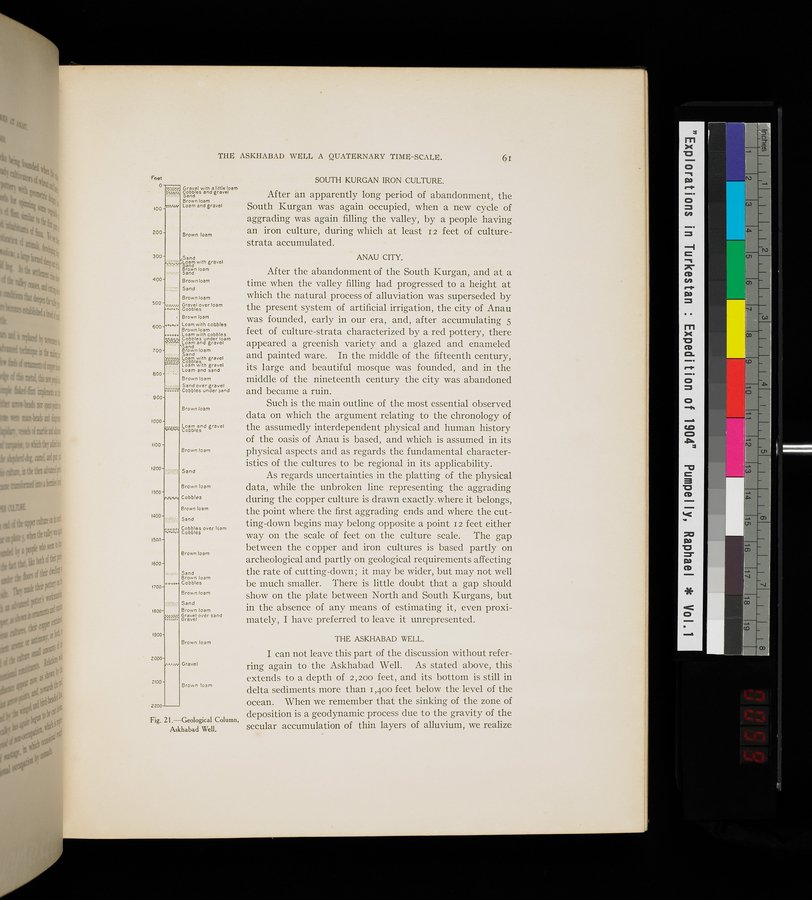
Brown loam THE ASKHABAD WELL.
2000 I can not leave this part of the discussion without refer-
Gravel ring again to the Askhabad Well. As stated above, this
2100 extends to a depth of 2,200 feet, and its bottom is still in
Brown loam delta sediments more than 1,400 feet below the level of the
2200 ocean. When we remember that the sinking of the zone of
Fig. 21
deposition Column, deposition is a geodynamic process due to the gravity of the
A.skhabad Well. secular accumulation of thin layers of alluvium, we realize
|
Copyright (C) 2003-2019
National Institute of Informatics(国立情報学研究所)
and
The Toyo Bunko(東洋文庫). All Rights Reserved.
本ウェブサイトに掲載するデジタル文化資源の無断転載は固くお断りいたします。