National Institute of Informatics - Digital Silk Road Project
| |||||||||
|
| Serindia : vol.3 |
 |
| Sec. | PREPARATIONS AT KHOTAN 1319 |
route to Ladak at the north foot of the Kara-koram passes, where the Kirghiz transport arranged for my big convoy of antiques and all heavy baggage would await us.
I knew well the formidable obstacles which the difficulties of the ground in the great mountain ranges, and even still more, perhaps, the utter barrenness of the inhospitable high plateaus, were bound to present. For the success of this concluding expedition the utmost care in all arrangements about transport and supplies was essential. The problem was made particularly serious by the fact that from the time of leaving Polur, the last inhabited place at the foot of the Kun-lun, until our arrival at the highest point on the Kara-kash where a depot of supplies could be sent up by Satip-aldi, the Kirghiz Beg on the Kara-koram route, the maintenance of ourselves and of our animals could be provided for only by means of supplies carried with us. The intended explorations could not possibly be carried out in less than forty days ; yet none of our available beasts of burden, ponies and donkeys, would be able on such high ground to carry more than their own fodder-supply for this period. For the complications introduced by this and other factors and for the efforts it cost to meet them I may refer to my Personal Narrative.
To my great relief R. B. Lal Singh safely rejoined me on July 20 after a separation of nearly three months, having successfully fulfilled all the tasks entrusted to him. He had first carried out very useful surveys along the Tien-shan from Ak-su to the watershed north of Kashgar (Maps Nos. 1, 5, 6, 9, 14, 19, 23). Then, after reaching Gûma in the south by a route not previously surveyed by us, he had mapped the last portion of terra incognita on the northern slopes of the Kunlun between the Kilian and Middle Kara-kash Rivers (Maps Nos. 16, 17, 21). A week later the final completion of my packing labours enabled me to take a short respite by paying a farewell visit to the site of the ancient Khotan at Yotkan. The annual washing for gold in the ` culture strata ' buried below the great deposit of alluvial loess soil had already begun, and I was able to add, by direct acquisitions from the villagers, to my collection of those terra-cotta grotesques and similar small antiques which the buried débris layers still continue to yield after decennia of exploitation.' I used the same occasion also for increasing my anthropometrical materials by measuring a considerable number of typical Khotan folk. Short as this last excursion into rural Khotan had to be, it helped to show me once again how rapidly the cultivation had been extending in recent years, not merely on the desert edges of the oasis, but also by reclamation of much land within, which in 1900-I I had still seen as marshy or shör-covered waste, e.g. round the Aidin-köl
or at Shor-bagh west of Khotan town.2
' Cf. above, pp. 97 sqq.
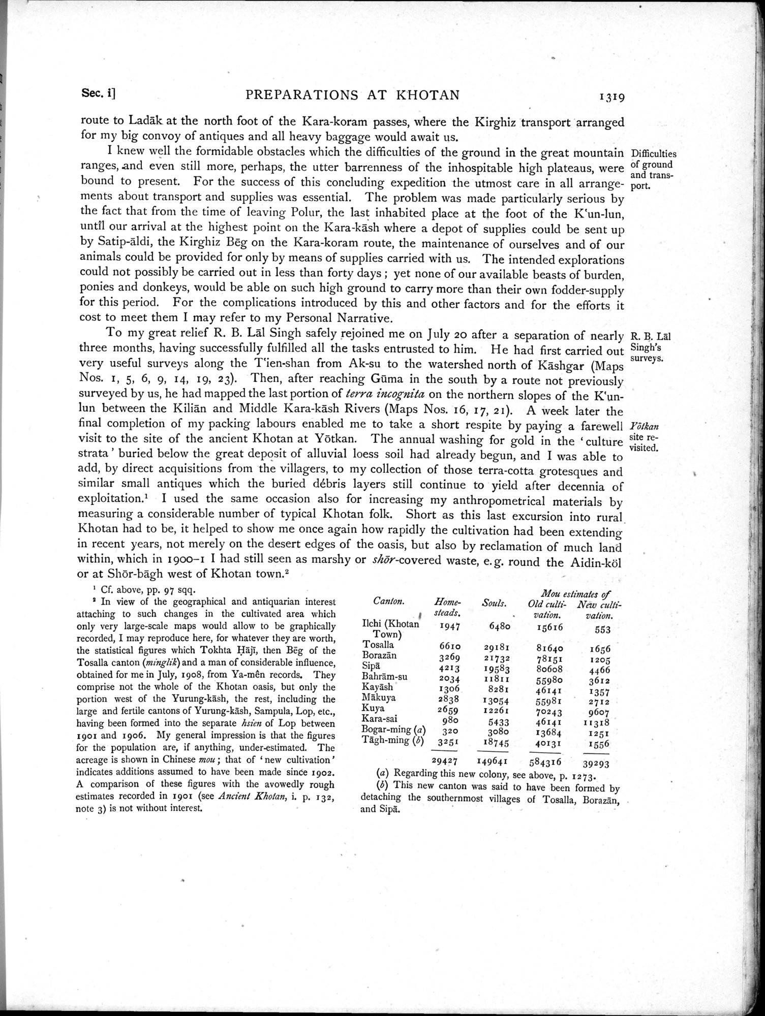
2 In view of the geographical and antiquarian interest attaching to such changes in the cultivated area which only very large-scale maps would allow to be graphically recorded, I may reproduce here, for whatever they are worth, the statistical figures which Tokhta Hâj1, then Beg of the Tosalla canton (minglik) and a man of considerable influence, obtained for me in July, x908, from Ya-mên records. They comprise not the whole of the Khotan oasis, but only the portion west of the Yurung-kâsh, the rest, including the large and fertile cantons of Yurung-kâsh, Sampula, Lop, etc., having been formed into the separate hsien of Lop between 1901 and 1906. My general impression is that the figures for the population are, if anything, under-estimated. The acreage is shown in Chinese mou; that of ` new cultivation' indicates additions assumed to have been made since 1902. A comparison of these figures with the avowedly rough estimates recorded in 1901 (see Ancient Khotan, i. p. 132, note 3) is not without interest.
| Canton. | Home- | Souls. | Mou estimates of Old tutti- New cul/= | |
| 1 | steads. | . | va/ôn. | vation. |
| Ilchi (Khotan Town) | 1947 | 6480 | 15616 | 553 |
| Tosalla | 6610 | 29181 | 81640 | 1656 |
| Borazân | 3269 | 21732 | 78151 | 1205 |
| Sipa' | 4213 | 195831 | 8o6o8 | 4466 |
| Bahrâm-su | 2034 | IISII | 5598o | 3612 |
| Kayâsh Makuya | 1306 2838 | 8281 13054 | 46141 55981 | 1357 2712 |
| Kura | 2659 | 12261 | 70243 | 9607 |
| Kara-sal | 980 | 5433 | 46141 | 11318 |
| Bogar-ming (a) | 320 | 3080 | 13684 | x251 |
| Tàgh-ming (b) | 3251 | 18745 | 40131 | 1556 |
|
| 29427 | 149641 | 584316 | 39293 |
Regarding this new colony, see above, p. 1273.
This new canton was said to have been formed by detaching the southernmost villages of Tosalla, Borazan, and Sipa.
Difficulties of ground and transport.
R. B. Lai Singh's surveys.
Yôlkan
site re-
visited.
|
Copyright (C) 2003-2019 National Institute of Informatics and The Toyo Bunko. All Rights Reserved.