国立情報学研究所 - ディジタル・シルクロード・プロジェクト
| |||||||||
|
| Ruins of Desert Cathay : vol.2 | |
| 中国砂漠地帯の遺跡 : vol.2 |
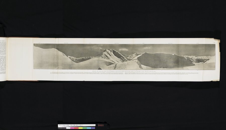 |
| 海抜約20、000フィートのハジ=ランガルの北にあるクンルン山脈主峰の分水嶺上にある雪に覆われた鞍部から撮られたパノラマ写真.このパノラマ写真(ii. pp. 478以下)は水平方向の四分の三以上を包含しており、東(左)から北(右)に展開する.方位点のおおよその位置がパノラマ上部に示されている.左端には、高い連峰の雪の斜面と、23、071フィートの三角峰の最高点に達する山頂(A)が見える.鞍部から見える山の最高点は、再現されたパノラマの一部には含まれない.南東へ、巨大な尾根の斜面のちょうどすぐそばに、21、 750フィートの三角峰K(B)と、その下に「ヤンギ=ダワン」まで続くと思われる渓谷が見える.その渓谷のはるか南側(C)に、風景は涸れた塩の湖床のある高地へと続く.これはジョンソンのラダクからの経路上にあたる.ハジ=ランガル(D)の位置を示す渓谷の上方に、南からのカラカシュ河の最高点の側面に位置する山脈が見える.南西方向にある雪をかぶった円頂は21、000フィート以上の高さがあり、クンルンの稜線の一部を形成している.さらに、この円頂は北への険しい屈曲部を形成しており、雪のあるピラミッド(F)までは見える.前景に下ってくると、北西方向の万年雪床(G)を見下ろす分水嶺の雪のある鞍部がある.PANORAMIC VIEW TAKEN FROM SNOWY COL ON WATERSHED OF MAIN KUN-LUN RANGE, NORTH OF HAJI LANGER, AT AN ELEVATION OF ABOUT 20,000 FEET ABOVE SEA LEVEL. The panorama (see ii. pp. 478 sqq. ) comprises over three-quarters of the horizon, extending from east (left) to north (right). The approximate positions of the cardinal points are indicated above the panorama. On the extreme left are seen the snow slopes and the crest (A) of a high massif, probably culminating in the triangulated peak of 23,071 feet. The highest point of the crest visible from the col does not fall within the potion of the panorama reprodeced. To the south-east, just by the slope of the great ridge, appears the triangulated peak K., 21,750 feet (B), and below it the valley which probably gives access to the 'Yangi Dawan.' Beyond the valleys farther south (C) the view extended to high plateaus with dry salt lake-beds, on Johnson's route from Ladak. Above the valley marking the position of Haji Langer (D) appears the range flanking the uppermost Kara-kash River from the south. The snowy dome to the south-west (E) rises to over 21,000 feet and forms part of the crest line of the Kun-lun. Farther on this makes a sharp bend to the north and is visible as far as the snowy pyramid (F). Below, in the foreground, is the snowy col of the watershed, overlooking névé beds north-westward (G), which feed the glacier (H) of an unexplored valley trending to the north and probably draining into the Panaz Darya (ii. p. 480). Due north, and behind the snowy spur flanking this valley on the right, there shows a serrated massif, without snow, probably part of the Panaz-Nissa watershed. On the right the panorama terminates on the north slope (I) of the western shoulder of the triangulated peak of 23,071 feet. |
n._~......~,._._._,~...~.....~^........~_...._..~ .~M__..w_..~.~~~..__.W.~.~._ ..,~..~..~_,~_.~~.~.~,v.. i ....,.~..~r..~._.~....~~_. ,....,~.M1~.......___,.~.~.~~~.y...,~.. v.~~ ..,~_...... ._.....__,.~.....,......._..
~„,.~~~.~.~._,~..v:~~~~ ~~~~..--~,~:~~,:~.~~~~~.~ ~M~M~ ~-:-~-::~~ ~~..~-.:::~,:._.-.~~ ~~_:-~~~ ~~..~.r..... .~,.~..~._~_.~. a ~ _...._r... ..._..~ ._ ._~._~...:..M _,W...,,~_ ~
~..~.~. ~-.~~..--___.._~.,....w.,..._..~._,w..y...~,.~.....
|
Copyright (C) 2003-2019
National Institute of Informatics(国立情報学研究所)
and
The Toyo Bunko(東洋文庫). All Rights Reserved.
本ウェブサイトに掲載するデジタル文化資源の無断転載は固くお断りいたします。