National Institute of Informatics - Digital Silk Road Project
| |||||||||
|
| Memoir on Maps of Chinese Turkistan and Kansu : vol.1 |
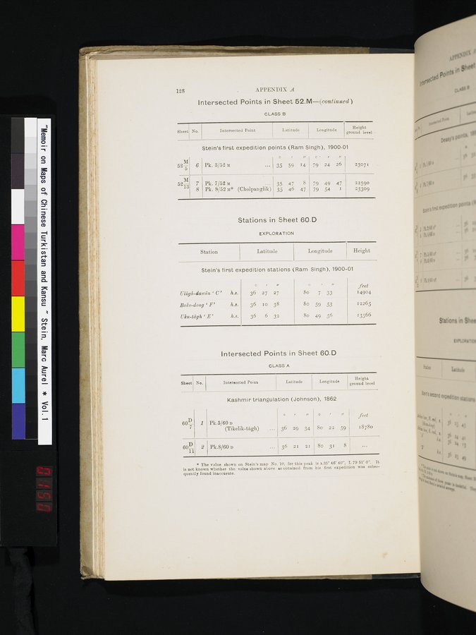 |
128 APPENDIX A
Intersected Points in Sheet 52.M—(continued)
CLASS B
| Sheet | No. | Intersected Point | Latitude | Longitude | Height ground level • |
Stein's first expedition points (Ram Singh), 1900-01
Stein's first expedition stations (Ram Singh), 1900-01
52M
Pk. 3/52 `1
O , /r
-• 35 59 14
C. r
79 24 26
23071
6
Pk. 7/52 M
Pk. 8/52 M* (Cholpanglik)
35 47 8
35 46 47
79 49 47
79 54 1
22590
23309
7
8
M 521—g
Stations in Sheet 60.D
EXPLORATION
| Station | Latitude | Longitude | Height | |
Ulûglc-dauâra ` C' h.s.
Boko-dong ` F' h.s.
Uku-tcigh `B' h.s.
O //
36 27 27
36 10 38
36 6 3z
o
8o 7 33 8o 59 53 8o 49 56
feet
14904
12265
13566
rr
* The value shown on Stein's map No. 10, for this peak is x35° 46' 40", L 79 51' 0". It is not known whether the value shown above as obtained from his first expedition was subsequently found inaccurate.
No.
Sheet
Intersected Points in Sheet 60.D
CLASS A
Kashmir triangulation (Johnson), 1862
Pk.3/60 v
(Tikelik-tâgh)
/r
36 29 34
8o 22 59
60D
7
60D
Pk.8/60 v
36 21 21
8o 31 8
2
1
feet
18780
Height
ground level
Longitude
Latitude
Intersected Point
|
Copyright (C) 2003-2019 National Institute of Informatics and The Toyo Bunko. All Rights Reserved.