国立情報学研究所 - ディジタル・シルクロード・プロジェクト
| |||||||||
|
| Scientific Results of a Journey in Central Asia, 1899-1902 : vol.1 | |
| 1899-1902年の中央アジア旅行における科学的成果 : vol.1 |
 |
| カルマク・クム、10月20日。Kalmak-kum, October 20. |
THE KODAJ-DARJA AND THE KASCHGAR•DARJA. 6t
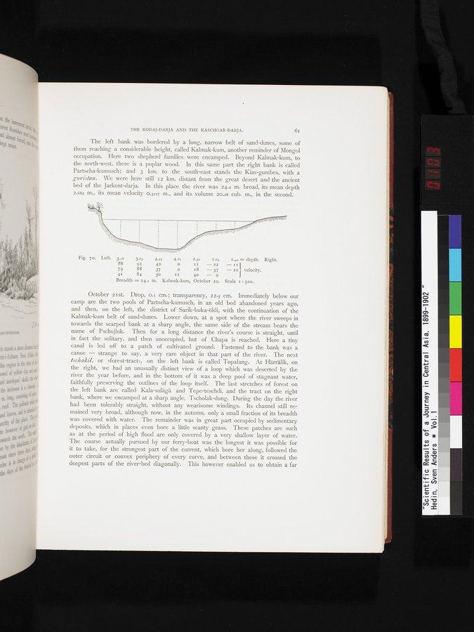
The left bank was bordered by a long, narrow belt of sand-dunes, some of them reaching a considerable height, called Kalmak-kum, another reminder of Mongol occupation. Here two shepherd • families were encamped. Beyond Kalmak-kum, to the north-west, there is a poplar wood. In this same part the right bank is called Partscha-kumusch; and 3 km. to the south-east stands the Kias-gumbes, with a gunistan. We were here still 12 km. distant from the great desert and the ancient bed of the Jarkent-darja. In this place the river was 24.2 m. broad, its mean depth 2.689 m., its mean velocity 0.3117 m., and its volume 20.28 cub. m., in the second.
Fig. 7o. Left. 3.o8 3.69 4.5$ 4.6o 2.5o I.69 1.40 = depth. Right.
88 91 40 o II — 22 — II
79 88 37 0 18 — 37 — 10 velocity.
41 84 3o II 40 — 9
Breadth = 24.2 m. Kalmak-kum, October 20. Scale r : 500.
October 21st. Drop, o.i cm.; transparency, 22.5 cm. Immediately below our camp are the two pools of Partscha-kumusch, in an old bed abandoned years ago, and then, on the left, the district of Sarik-buka-öldi, with the continuation of the Kalmak-kum belt of sand-dunes. Lower down, at a spot where the river sweeps in towards the scarped bank at a sharp angle, the same side of the stream bears the name of Pschujluk. Then for a long distance the river's course is straight, until in fact the solitary, and then unoccupied, hut of Chapa is reached. Here a tiny canal is led off to a patch of cultivated ground. Fastened to the bank was a canoe — strange to say, a very rare object in that part of the river. The next tschakil, or »forest-tract», on the left bank is called Topalang. At Härrälik, on the right, we had an unusually distinct view of a loop which was deserted by the river the year before, and in the bottom of it was a deep pool of stagnant water, faithfully preserving the outlines of the loop itself. The last stretches of forest on the left bank are called Kala-sulägä and Tepe-teschdi, and the tract on the right bank, where we encamped at a sharp angle, Tscholak-dung. During the day the river had been tolerably straight, without any wearisome windings. Its channel still remained very broad, although now, in the autumn, only a small fraction of its breadth was covered with water. The remainder was in great part occupied by sedimentary deposits, which in places even bore a little scanty grass. These patches are such as at the period of high flood are only covered by a very shallow layer of water. The course actually pursued by our ferry-boat was the longest it was possible for it to take, for the strongest part of the current, which bore her along, followed the outer circuit or convex periphery of every curve, and between these it crossed the deepest parts of the river-bed diagonally. This however enabled us to obtain a far
|
Copyright (C) 2003-2019
National Institute of Informatics(国立情報学研究所)
and
The Toyo Bunko(東洋文庫). All Rights Reserved.
本ウェブサイトに掲載するデジタル文化資源の無断転載は固くお断りいたします。