国立情報学研究所 - ディジタル・シルクロード・プロジェクト
| |||||||||
|
| Scientific Results of a Journey in Central Asia, 1899-1902 : vol.1 | |
| 1899-1902年の中央アジア旅行における科学的成果 : vol.1 |
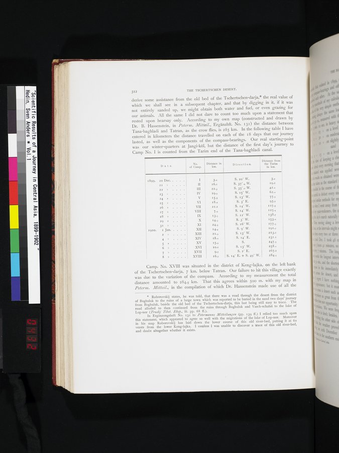 |
312 THE TSCHERTSCHEN DESERT.
derive some assistance from the old bed of the Tschertschen-darja,* the real value of which we shall see in a subsequent chapter, and that by digging in it, if it was not entirely sanded up, we might obtain both water and fuel, or even grazing for our animals. All the same I did not dare to count too much upon a statement that rested upon hearsay only. According to my own map (constructed and drawn by Dr. B. Hassenstein, in Pelerm. Mitteil., Ergänzhft. No. 131) the distance between Tana-baghladi and Tatran, as the crow flies, is 285 km. In the following table I have entered in kilometers the distance travelled on each of the i 8 days that our journey lasted, as well as the components of the compass-bearings. Our real starting-point was our winter-quarters at Jangi-köl, but the distance of the first day's journey to Camp No. I is counted from the Tarim end of the Tana-baghladi canal.
Camp. No. XVIII was situated in the district of Keng-lajka, on the left bank of the Tschertschen-darja, 7 km. below Tatran. Our failure to hit this village exactly was due to the variation of the compass. According to my measurement the total distance amounted to 284.5 km. That this agrees within 500 m. with my map in Pelerm. Mitteil., in the compilation of which Dr. Hassenstein made use of all the
* Roborovskij states, he was told, that there was a road through the desert from the district of Boghuluk to the ruins of a large town which was reported to be buried in the sand two days' journey from Boghuluk, beside the old bed of the Tschertschen-darja, this last being still easy to trace. The road alluded to then continued from the ruins through Boghuluk and Vasch-schahri to the lake of Lop-nor (Trudij Tibet..Eksp., iii. pp. 68 ff.).
In Ergänzungsheft No. 131 to Peterrnanns Mitteilungen (pp. 139 ff.) I relied too much upon this statement, which appeared to agree so well with the migrations of the lake of Lop-nor. Moreover in his map Roborovskij has laid down the lower course of this old river-bed, putting it at 6o versts from the lower Keng-lajka. I confess I was unable to discover a trace of this old river-bed, and doubt altogether whether it exists.
No.
of Camp.
Distance in km.
Distance from
the Tarim
in km.
I) a t e.
Direction.
1899. 20 Dec. . .
2I » . .
22
23 »
24 »
25 »
26 »
27 »
28 »
29 »
31 »
1900. I Jan
2 »
4 »
5 »
6 »
7 »
8
II
III
IV
V
VI
VII
VIII
IX
X
XI
XII
XIII
XIV
XV
XVI
XVII
XVIII
3.2
16.6
22.3
19.9 15.5 18.» 2I.8
7.9 13.3 14.3 24.3 14.4 2I.9
18.0
15.9 I 0.6
9.7
16.7
3.2
19.8
42•=
62.0
77.5
95.7
I 17•5
I 25.4
138.7
153.0
177.3
191.7
213.6
231.6
247.s
258.x
267.8
284.5
S. 20° W.
S. 37°.4 W.
S. 35°.: W. S. 15° W. 5.13°W S. 3° E.
S. 14° W. S. 14° W. S. 12° W. S. 3° W. S. 1.6° W.
S. 9' W.
S. 13° W.
S. 14° E.
S.
S. 13° W.
S. 2° E.
S. 14° E. + S. 49° W.
|
Copyright (C) 2003-2019
National Institute of Informatics(国立情報学研究所)
and
The Toyo Bunko(東洋文庫). All Rights Reserved.
本ウェブサイトに掲載するデジタル文化資源の無断転載は固くお断りいたします。