国立情報学研究所 - ディジタル・シルクロード・プロジェクト
| |||||||||
|
| Scientific Results of a Journey in Central Asia, 1899-1902 : vol.1 | |
| 1899-1902年の中央アジア旅行における科学的成果 : vol.1 |
 |
| ハンゲトリク、10月25日。Hangetlik, October 25. |
72
THE TARIM RIVER.
Steppe and underwoods were the predominant forms of vegetation passed during the day; we only observed full-grown poplars at a single bend, and they were few in number. The names of the local topography are — on the right, Paschalik, with a pasture-ground to the south of it called Kara-toghrak; and, on the left, Pachmamasar, a small cemetery, with the usual poles and streamers, embowered in a clump of poplars, beside a loop of the river that was abandoned two years ago. That water had flowed round this loop at a quite recent date was evidenced by the naked condition of its bed; for loops which have been abandoned any length of time are generally overgrown with vegetation, often indeed smothered under young forest, reeds, and bushes. Then, on the right bank, we had Jar-kotan. At Jamal-töschdi there are two small loops quite close together, each containing the usual lagoon. Another winding of precisely similar character occurs at Kan-toghrighi, or the »Kings' Poplar»; and there also dwelt a shepherd family beside a masar bearing the same name. Upon reaching Kodajlik, we were about 46 km. from the bazar of Bisch-arik and 6o km. from Kuba-örtäng, a place on the great Ak-su highway, one stage from Ak-su. These off-hand estimates of distance which the natives give are of course by no means trustworthy; at most, they are approximations only. According to my previous map, the distance between Kodajlik and Bisch-arik is indeed 46 km., but the exact agreement between the two can only be set down as a pure coincidence.
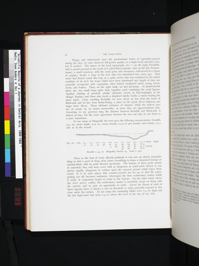
At our camp at Hangetlik the river gave the following measurements: breadth, 33.3 m.; mean depth, 0.785 m.; mean velocity, 0.5026 m. per second; and volume, 13.13 cub. m. in the second.
Fig. 76. Left. 0.=4 0.=6 0.o8 0.22 0.58 o.9! I.x5 1.48 2.59 1.32 =depth. Right.
12 13 25 46 67 75 69 84 6o 16
4 64 64 76 6o 31 J} velocity.
48 68 61 18
Breadth = 33.3 m. Hangetlik, October 25. Scale i : 300.
Close to the foot of every alluvial peninsula it was now an almost invariable thing to find a pool of deep, clear water, resembling in shape a sharpened lozenge or scimitar-blade with its point directed up-stream. The bottom of these pools consist of extremely fine, soft mud, every whit as dangerous as quick-sand; indeed, it was almost equally dangerous to venture upon the exposed ground which edges them round. It is in such places that counter-currents are set up, or that the water, getting cut off, becomes stationary, whereupon the finer sedimentary matter which it holds in suspension begins to settle to the bottom. On the other hand, where the river moves swiftly, the sedimentary matter is invariably swept on along with the current, and so gets no opportunity to settle. Across the throat of each of these lagoons there is always a sort of threshold or ridge, generally exposed or else close under the surface. At our camp the containing banks were 2.73 m. high, and the last high-water had risen 1.49 m. above the level of the day of our visit.
|
Copyright (C) 2003-2019
National Institute of Informatics(国立情報学研究所)
and
The Toyo Bunko(東洋文庫). All Rights Reserved.
本ウェブサイトに掲載するデジタル文化資源の無断転載は固くお断りいたします。