国立情報学研究所 - ディジタル・シルクロード・プロジェクト
| |||||||||
|
| Memoir on Maps of Chinese Turkistan and Kansu : vol.1 | |
| 中国領トルキスタンおよび甘粛の地図に関する覚書 : vol.1 |
 |
42-7
1
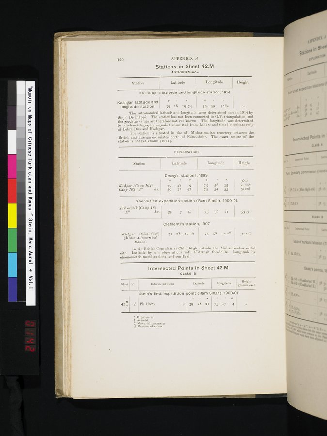
120
APPENDIX A
Longitude
Latitude
Height
Station
Height
Latitude
Longitude
feet
'4400* 512ot
75 58 35
75 54 55
O
, „
39 28 19
39 32 47
Kashgar (Camp 162)
Camp 162 "A" h..c.
Sheet
No.
Latitude
Intersected Point
Longitude I Height
ground level
Pk.1/42m
O , M
39 28 21
Stations in Sheet 42.M
ASTRONOMICAL
De Filippi's latitude and longitude station, 1914
Kashgar latitude and longitude station
O , J/
39 28 19'74
,
75 59 5'64
/,
The astronomical latitude and longitude were determined here in 1914 by Sir F. De Filippi. The station has not been connected to G.T. triangulation, and the geodetic values are therefore not yet•known. The longitude was determined by wireless telegraphic signals transmitted from Lahore and timed simultaneously at Dehra Dan and Kashgar.
The station is situated in the old Muhammadan cemetery between the British and Russian consulates north of Kline-shahr. The exact ynature of the station is not yet known (1921).
EXPLORATION
Deasy's stations, 1899
Stein's first expedition station (Ram Singh), 1900-01.
lash-malik (Camp 19)
h.s. 39 7 47 75 36 21 5313
Clementi's station, 1907
Kashgar (Chini-bdgh) 39 28 45.1§ 75 58 o • o*
(Minor astronomical station.)
In the British Consulate at Chini-bKgh outside the Muhammadan walled city. Latitude by sun observations with 4"-transit theodolite. Longitude by chronometric meridian distance from Ikul. •
Intersected Points in Sheet 42.M
CLASS B
Stein's first expedition point (Ram Singh), 1900-01
4213+
* Hypsometer.
t Aneroid.
Mercurial barometer. § Unadjusted values.
q
75 17 4
Station
|
Copyright (C) 2003-2019
National Institute of Informatics(国立情報学研究所)
and
The Toyo Bunko(東洋文庫). All Rights Reserved.
本ウェブサイトに掲載するデジタル文化資源の無断転載は固くお断りいたします。