国立情報学研究所 - ディジタル・シルクロード・プロジェクト
| |||||||||
|
| Memoir on Maps of Chinese Turkistan and Kansu : vol.1 | |
| 中国領トルキスタンおよび甘粛の地図に関する覚書 : vol.1 |
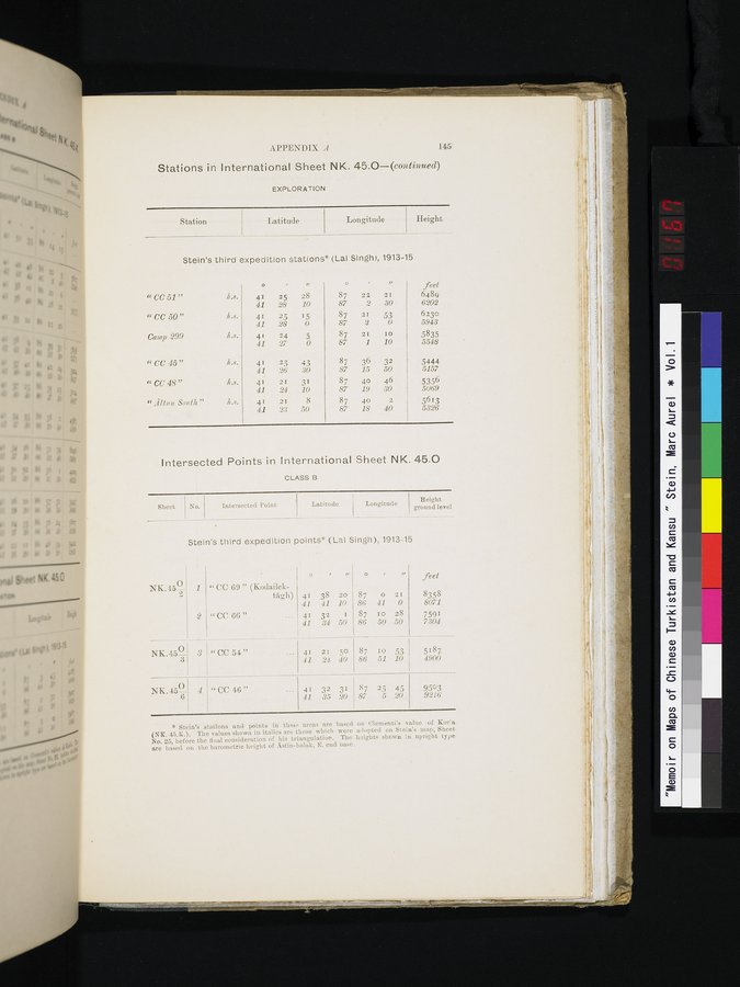 |
APPENDIX A 145
Stations in International Sheet NK. 45.0—(continued)
EXPLORATION
| Station | Latitude | Longitude | Height | ||
Stein's third expedition stations* (Lal Singh), 1913-15
|
|
| o |
| a | o |
| u | feet |
| "CC51" | /.S. | 41 | 25 | 28 | 87 | 22 | 21 | 6489 |
|
|
| 41 | 28 | 10 | 87 | 2 | 30 | 6202 |
| «CC 50" | /.s. | 41 | 25 | 15 | 87 | 21 | 53 | 6230 |
|
|
| 41 | 28 | 0 | 87 | 2 | 0 | 5943 |
| Camp 299 | /.s. | 41 | 24 | 5 | 87 | 21 | 10 | 5835 |
|
|
| 41 | 27 | 0 | 87 | 1 | 10 | 5548 |
| « CC 45" | h.s. | 41 | 23 | 43 | 87 | 36 | 32 | .5444 |
|
|
| 41 | 26 | 30 | 87 | 15 | 50 | 5157 |
| "CC48" | h..c. | 41 | 21 | 31 | 87 | 40 | 46 | 5356 |
|
|
| 41 | 24 | 10 | 87 | 19 | 30 | 5069 |
| "111,tiin South" | h.s. | 41 | 21 | 8 | 87 | 40 | 2 | 5613 |
|
|
| 41 | 23 | 50 | 87 | 18 | 40 | 5326 |
Intersected Points in International Sheet NK. 45.0
CLASS B
| Sheet No. | Intersected Point | Latitude | Longitude | Height |
Stein's third expedition points* (Lal Singh), 1913-15
NK. 45__
1
2
" CC 69 " (Kodailel:-
tF1gh) 41 38 20
41 41 10
"CC 66"
••• 41 32 I
41 34 50
o
87 0 21
86 41 0
87 10 28
86 50 50
ii
feet
8358
8071
7591
7304
NK.45~
3
NK.45 6
7 "CC 54"
4 " CC 46"
41 21 50
41 24 40
41 32 31
41 35 20
87 25 45
87 5 20
87 Io 53 5187
86 51 • 10 4900
9503
9216
* Stein's stations and points in these areas are based on Clementi's value of Kor'a (NK. 45.K.). The values shown in italics are those which were adopted on Stein's map, Sheet No. 25, before the final consideration of his triangulation. The heights shown in upright type are based on the barometric height of Astin-bulak, E. end base.
|
Copyright (C) 2003-2019
National Institute of Informatics(国立情報学研究所)
and
The Toyo Bunko(東洋文庫). All Rights Reserved.
本ウェブサイトに掲載するデジタル文化資源の無断転載は固くお断りいたします。