国立情報学研究所 - ディジタル・シルクロード・プロジェクト
| |||||||||
|
| Memoir on Maps of Chinese Turkistan and Kansu : vol.1 | |
| 中国領トルキスタンおよび甘粛の地図に関する覚書 : vol.1 |
 |
Height
Longitude
Station
Latitude
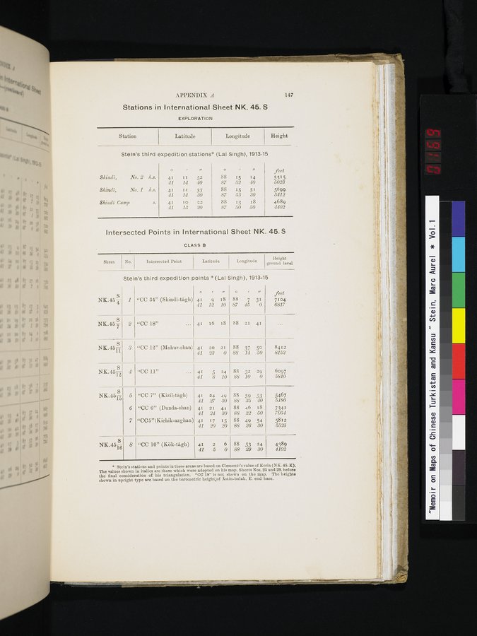
APPENDIX A
Stations in International Sheet NK. 45. S
EXPLORATION
147
Stein's third expedition stations* (Lai Singh), 1913-15
|
|
|
| o |
| ir |
|
|
| feet |
| Slaindi, | No. 2 | Ia.s. | 41 | 11 | 52 | 88 | 15 | 14 | 5315 |
|
|
|
| 41 | 14 | 40 | 87 | 52 | 40 | 5023 |
| Slaindi, | No. 1 | Ic.s. | 41 | II | 37 | 88 | 15 | 51 | 5699 |
|
|
|
| 41 | 14 | 30 | 87 | 53 | 30 | 5412 |
| $%b2ndS Camp |
| s. | 41 | 10 | 22 | 88 | 13 | 18 | 4689 |
|
|
|
| 41 | 13 | 20 | 87 | 50 | 50 | 4402 |
Intersected Points in International Sheet NK. 45.S
CLASS B
Intersected T'oint
Latitude
Longitude
Height
ground level
Sheet
Stein's third expedition points *(Lai Singh), 1913-15
| NK.45 4 | 1 | "CC 34" (Shindi-tagh) | ° 41 41 | ' 9 12 | " 18 10 | ° 88 87 | ' 7 45 | " 31 0 | feet 7104 6817 |
| NK.45 7 | 2 | "CC 18" ... | 41 | 16 | 18 | 88 | 21 | 41 | ... |
| N, .451— | 3 | "CC 12" (IVlohur-shan) | 41 | 20 | 21 | 88 | 37 | 50 | 8412 |
|
|
|
| 41 | 23 | 0 | 88 | 14 | 50 | 8152 |
| NK.451 | 4 | "CC 11" ... | 41 | 5 | 24 | 88 | 32 | 29 | 6097 |
|
|
|
| 41 | 8 | 10 | 88 | 10 | 0 | 5810 |
| NK.4515 | 5 | "CC 7" (Kizil-tâgh) | 41 | 24 | .19 | 88 | 59 | 53 | 5467 |
|
|
|
| 41 | 27 | 30 | 88 | 35 | 40 | 5180 |
|
| 6 | "CC 6" (Dunda-shan) | 41 | 21 | 44 | 88 | 46 | 18 | 7341 |
|
|
|
| 41 | 24 | 30 | 88 | 22 | 50 | 7054 |
|
| 7 | "CC5"(Kichik-azghan) | 41 | 17 | 15 | 88 | 49 | 54 | 5812 |
|
|
|
| 41 | 20 | 20 | 88 | 26 | 30 | 5525 |
| NK.451fi | 8 | "CC 10" (Kök-tâgh) | 41 | 2 | 6 | 88 | 53 | 24 | 4389 |
|
|
|
| 41 | 5 | 0 | 88 | 29 | 30 | 4102 |
* Stein's stations and points in these areas are based on Clementi's value of Kula (N K. 45. K). The values shown in italics are those which were adopted on his map, Sheets Nos. 25 and 29. before the final consideration of his triangulation. "CC 18" is not shown on the map. The heights shown in upright type are based on the barometric height;of Astin-bulak, E. end base.
No.
|
Copyright (C) 2003-2019
National Institute of Informatics(国立情報学研究所)
and
The Toyo Bunko(東洋文庫). All Rights Reserved.
本ウェブサイトに掲載するデジタル文化資源の無断転載は固くお断りいたします。