国立情報学研究所 - ディジタル・シルクロード・プロジェクト
| |||||||||
|
| Memoir on Maps of Chinese Turkistan and Kansu : vol.1 | |
| 中国領トルキスタンおよび甘粛の地図に関する覚書 : vol.1 |
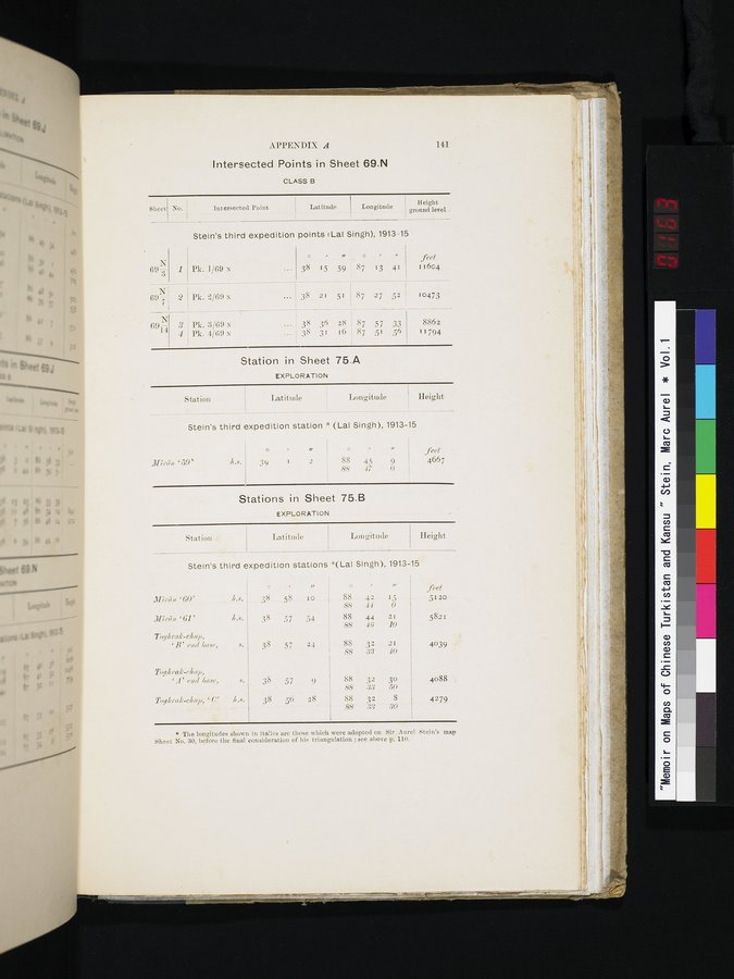 |
APPENDIX A 141
Intersected Points in Sheet 69.N
CLASS B
Stein's third expedition points (Lai Singh), 1913-15
| T 69-3 | 1 | Pk. 1/69 x | 38 | 1 5 21 36 31 | ,, 59 51 28 16 | o 87 87 87 87 | 13 27 57 51 | 41 52 33 56 | feet 11604 10473 8862 11794 |
| N; 69 ---I 2 | Pk. 2/69 N | 38 | |||||||
| 691-4 | 3 Pk. 3/69 N 38 4 Pk. 4/69 N 38 | ||||||||
Station in Sheet 75.A
EXPLORATION
Height
ground level -
Sheet
No.
Intersected Point I Latitude
Longitude
Station
Latitude
Longitude Height
Stein's third expedition station ;' (Lal Singh), 1913-15
H
/ 39 i 2
O u
88 45 9 88 ,f7 0
D'17,•(7u. '59'
feet
4667
Stations in Sheet 75.B
EXPLORATION
| Station | Latitude | Longitude | Height | |||||||||
Stein's third expedition stations ' (Lal Singh), 1913-15
|
|
| o | • | i, | o |
| r, | ixet feet |
| :1l7rhn '60' | I.s. | 38 | 58 | lo | 88 | 42 | 15 | 5120 |
|
|
|
|
|
| 88 | 44 | 0 |
|
| 317r(7)t '61' | %l.k. | 38 | 57 | 54 | 88 | 44 | 21 | 5821 |
|
|
|
|
|
| 8S | 4(3 | I0 |
|
| 1'og/rrak-c1 ap, `B' end Gase, | s. | 38 | 57 | 24 | 88 88 | 332 | 21 40 | 4039 |
| Toghrak-(•1 ap, 'A' end Gase, | Y. | 38 | 57 | 9 | 88 | 32 | 3o | 4088 |
|
|
|
|
|
| 88 | .33 | 50 |
|
| 2'ogh ral•-c1 azi, ` C' | Ir.. s. | 38 | 56 | 28 | 88 | 32 | 8 | 4279 |
|
|
|
|
|
| .88 | 88 | .30 |
|
* The longitudes shown in italics are those which were adopted on Sir Aurel Stein's map Sheet No. 30, before the final consideration of his triangulation ; see above p. 110.
|
Copyright (C) 2003-2019
National Institute of Informatics(国立情報学研究所)
and
The Toyo Bunko(東洋文庫). All Rights Reserved.
本ウェブサイトに掲載するデジタル文化資源の無断転載は固くお断りいたします。