国立情報学研究所 - ディジタル・シルクロード・プロジェクト
| |||||||||
|
| Innermost Asia : vol.2 | |
| 極奥アジア : vol.2 |
 |
Sec. iii] SITE OF ZAHIDAN AND LATER RUINS TO THE NORTH-WEST 935
or storage place for ice. The central hall in the former has a niche towards the SW. which agrees with its supposed use as a mosque. The structure beyond has a dome which rests on a wall fully 7 feet thick and only about 4 feet high above the ground. The diameter of the interior is 43 feet. The vaulting as far as preserved appears to consist of horizontal courses of bricks. But the centre .may have once been surmounted by a true dome. In order to secure an adequate supply of ice under the climatic conditions of Sistân it would probably be necessary to have a considerable space flooded with a very shallow sheet of water. This might explain the position of this curious structure at some distance outside the circumvallated areas. The only other purpose for which it might have been built is that of a granary ; but this would scarcely be placed outside the protected area.6
Proceeding from Zâhidân to the NW. along the same low clay ridge that bears the ruined town, we passed over a wind-eroded tract for more than a mile. Here the line of an old canal was marked very clearly, with the spoil banks rising some 3 feet above the surface of the ground and the bottom between them quite hard. An abundance of pottery fragments of the same type as at Zâhidân strewed the bare soil where clear of sand. But no ` ribbed ' pieces were picked up until we neared the ruined Min-di- known as Mil-i-Kâsimâbâd from a neighbouring village. Here, too, they were to be found only on wind-eroded ground and were rare in comparison with the plentiful pottery remains of manifestly Muhammadan times. Mr. Tate has fully described this ruined tower, which rising over 7o feet above the ground level is a conspicuous landmark.' It will therefore suffice to add here that the baked bricks of which it is built measure 14"x 8"x 2", and that at the base its diameter inside is about io feet and its walls nearly 6 feet thick. Two inscriptions in Arabic executed with bricks in relievo crown the top of the Minâr. The lower
one mentions Malik Tâjuddin the elder, who died in A. D. 1163-4, and the higher one his great-grandson of the same name. Hence Mr. A. G. Ellis, the translator of the inscriptions, concludes that ` the elder Tâjuddin presumably died leaving his minaret unfinished '.S This supplies a clue to the approximate period of the pottery found around the Minâr and the ruins of small structures close by to the west.
For this chronological reason some constructive features observed here deserve special notice. The sun-dried bricks used in these square structures all measure 12"x 7"x 22". One of the structures is proved by a prayer niche to have served as a mosque. In this and a couple of other ruins the barrel vaulting was produced by horizontally overlapping brick courses ; but below this a kind of revetment was applied with bricks set on edge along their longer
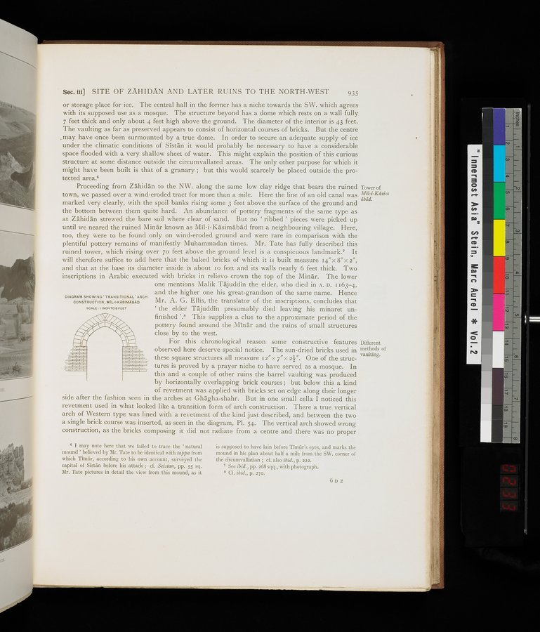
side after the fashion seen in the arches at Ghâgha-shahr. But in one small cella I noticed this revetment used in what looked like a transition form of arch construction. There a true vertical arch of Western type was lined with a revetment of the kind just described, and between the two a single brick course was inserted, as seen in the diagram, Pl. S4. The vertical arch showed wrong construction, as the bricks composing it did not radiate from a centre and there was no proper
Tower of Mil-i-Kâsim
âbàd.
Different methods of vaulting.
DIAGRAM SHOWING `TRANSITIONAL' ARCH
CONSTRUCTION, MÎL-I-KASIMABAD
SCALE : t INCH TO ß FEET
6 I may note here that we failed to trace the ` natural mound ' believed by Mr. Tate to be identical with tappa from which Timfir, according to his own account, surveyed the capital of Sistan before his attack ; cf. Seistan, pp. 55 sq. Mr. Tate pictures in detail the view from this mound, as it
is supposed to have lain before Timûr's eyes, and marks the mound in his plan about half a mile from the SW. corner of the circumvallation ; cf. also ibid., p. 222.
See ibid., pp. 268 sqq., with photograph.
8 Cf. ibid., p. 27o.
6D2
|
Copyright (C) 2003-2019
National Institute of Informatics(国立情報学研究所)
and
The Toyo Bunko(東洋文庫). All Rights Reserved.
本ウェブサイトに掲載するデジタル文化資源の無断転載は固くお断りいたします。