国立情報学研究所 - ディジタル・シルクロード・プロジェクト
| |||||||||
|
| Scientific Results of a Journey in Central Asia, 1899-1902 : vol.1 | |
| 1899-1902年の中央アジア旅行における科学的成果 : vol.1 |
 |
| 蒸発の効果。Effect of evaporation. |
258 THE LAKES BESIDE TIIE LOWER TARIN.
graphical problems, they also at the same time contribute in an essential degree towards the solution of important questions of physical geography.
The canal which feeds the Karaunelik-köl is narrowest at the point where it branches off from the right bank of the Tarim, though even there its breadth amounts to 17.3o m. Thence it gradually widens as it advances, until at its entrance into the lake its width is quite double the figure just quoted. The mean depth was o.60 m.; the mean velocity of the current, 0.223 m.; and the volume, 2.3 cub.m. in the second. At this point the maximum depth of the canal was 0.77 m. When the river drops this much, as it does by the autumn, the inflow into the lake ceases, but not before, because the canal as it approaches the lake grows at the same time both wider and deeper. For this reason the only spot at which we were able to measure its current with sufficient certainty was over the threshold, where the breadth amounted to i 7.30 m.
The volume of 2.3 cub.m., the measure of the contribution which the Karaunelikköl levies upon the Tarim every second, suggests interesting conclusions as to the mutual relations between the river and the lake. Seeing that the volume of the river at this time was 72 cub.m., then the Karaunelik-köl drained away '/31th of the river's total flood, and to that extent deprived the Kara-koschun of an equivalent amount. In other words, so long as the Karaunelik-köl is kept open, it robs the terminal basin of the Tarim of a large volume of its water. But to this problem, which throws so much light upon the question of the steady shrinkage and desiccation of the Kara-koschun, we shall return again lower down.
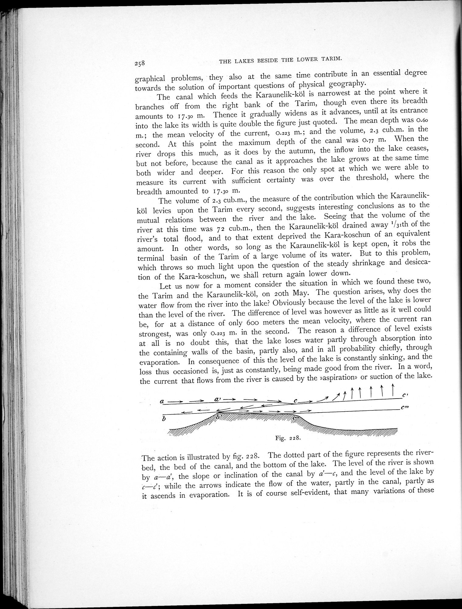
Let us now for a moment consider the situation in which we found these two, the Tarim and the Karaunelik-köl, on 20th May. The question arises, why does the water flow from the river into the lake? Obviously because the level of the lake is lower than the level of the river. The difference of level was however as little as it well could be, for at a distance of only Goo meters the mean velocity, where the current ran strongest, was only 0.223 m. in the second. The reason a difference of level exists at all is no doubt this, that the lake loses water partly through absorption into the containing walls of the basin, partly also, and in all probability chiefly, through evaporation. In consequence of this the level of the lake is constantly sinking, and the loss thus occasioned is, just as constantly, being made good from the river. In a word, the current that flows from the river is caused by the »aspiration» or suction of the lake.
The action is illustrated by fig. 228. The clotted part of the figure represents the riverbed, the bed of the canal, and the bottom of the lake. The level of the river is shown by a—d, the slope or inclination of the canal by a'—c, and the level of the lake by c—c'; while the arrows indicate the flow of the water, partly in the canal, partly as it ascends in evaporation. It is of course self-evident, that many variations of these
|
Copyright (C) 2003-2019
National Institute of Informatics(国立情報学研究所)
and
The Toyo Bunko(東洋文庫). All Rights Reserved.
本ウェブサイトに掲載するデジタル文化資源の無断転載は固くお断りいたします。