国立情報学研究所 - ディジタル・シルクロード・プロジェクト
| |||||||||
|
| Scientific Results of a Journey in Central Asia, 1899-1902 : vol.1 | |
| 1899-1902年の中央アジア旅行における科学的成果 : vol.1 |
 |
| カラ・クルの水路、4月29日。The channel to Kara-köl; April 29. |
494 THE TARIM DELTA.
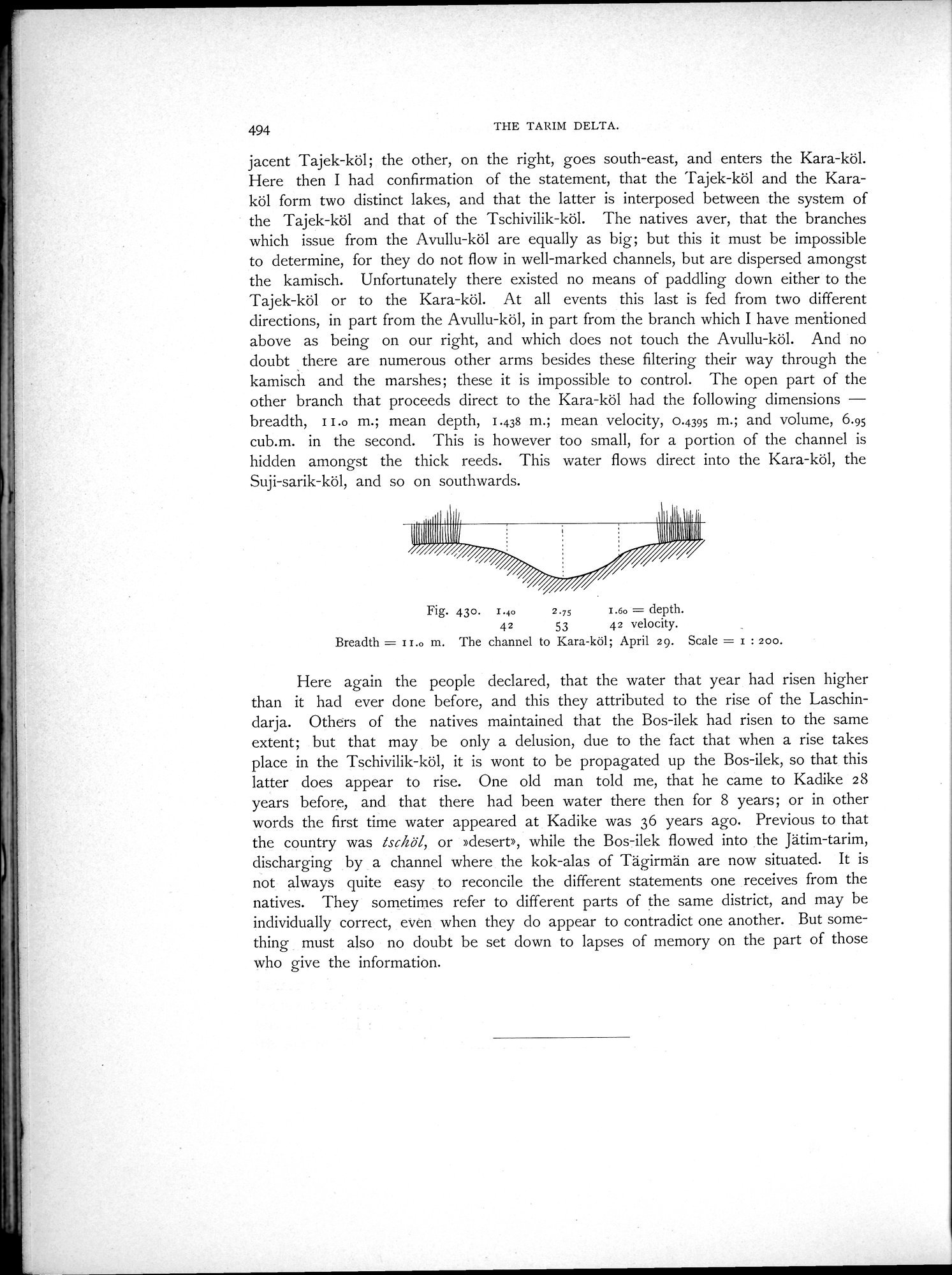
jacent Tajek-köl; the other, on the right, goes south-east, and enters the Kara-köl. Here then I had confirmation of the statement, that the Tajek-köl and the Karaköl form two distinct lakes, and that the latter is interposed between the system of the Tajek-köl and that of the Tschivilik-köl. The natives aver, that the branches which issue from the Avullu-köl are equally as big; but this it must be impossible to determine, for they do not flow in well-marked channels, but are dispersed amongst the kamisch. Unfortunately there existed no means of paddling down either to the Tajek-köl or to the Kara-köl. At all events this last is fed from two different directions, in part from the Avullu-köl, in part from the branch which I have mentioned above as being on our right, and which does not touch the Avullu-köl. And no doubt there are numerous other arms besides these filtering their way through the kamisch and the marshes; these it is impossible to control. The open part of the other branch that proceeds direct to the Kara-köl had the following dimensions — breadth, II.0 m.; mean depth, 1.438 m.; mean velocity, 0.4395 m.; and volume, 6.95 cub.m. in the second. This is however too small, for a portion of the channel is hidden amongst the thick reeds. This water flows direct into the Kara-köl, the Suji-sarik-köl, and so on southwards.
IBM
Fig. 430. I.40 2.75 1.60 = depth.
42 53 42 velocity.
Breadth = I r.o m. The channel to Kara-köl; April 29. Scale = r : 200.
Here again the people declared, that the water that year had risen higher than it had ever done before, and this they attributed to the rise of the Laschindarja. Others of the natives maintained that the Bos-ilek had risen to the same extent; but that may be only a delusion, due to the fact that when a rise takes place in the Tschivilik-köl, it is wont to be propagated up the Bos-ilek, so that this latter does appear to rise. One old man told me, that he came to Kadike 28 years before, and that there had been water there then for 8 years; or in other words the first time water appeared at Kadike was 36 years ago. Previous to that the country was lschöl, or »desert», while the Bos-ilek flowed into the Jätim-tarim, discharging by a channel where the kok-alas of Tägirmän are now situated. It is not always quite easy to reconcile the different statements one receives from the natives. They sometimes refer to different parts of the same district, and may be individually correct, even when they do appear to contradict one another. But something must also no doubt be set down to lapses of memory on the part of those who give the information.
|
Copyright (C) 2003-2019
National Institute of Informatics(国立情報学研究所)
and
The Toyo Bunko(東洋文庫). All Rights Reserved.
本ウェブサイトに掲載するデジタル文化資源の無断転載は固くお断りいたします。