国立情報学研究所 - ディジタル・シルクロード・プロジェクト
| |||||||||
|
| Scientific Results of a Journey in Central Asia, 1899-1902 : vol.1 | |
| 1899-1902年の中央アジア旅行における科学的成果 : vol.1 |
 |
| 単独の砂丘。INDIVIDUAL DUNE. | |
| 三連砂丘。DUNE-TRIPLETS. | |
| 三連砂丘。DUNE-TRIPLETS. |
ON DUNE-FORMATION AND SANDY THRESHOLDS. 351
meters, Keng-lajka lies at 1,18o meters, so that in the course of our journey between these two places we had ascended 30o meters. Thus the Tschertschen-darja has a fall towards the Kara-buran 30o meters greater than that of the Tarim, although the distance is only very slightly longer. And the difference becomes still more sharply accentuated, when it is remembered that Jarkent and Tschertschen stand at the same altitude, although the distance between the former and the point of confluence of the two rivers is I,25o km., whilst from Tschertschen to the same point it is only 450 km.* The contour-lines of the East Turkestan basin thus cut the long bajir-groove virtually at right angles; consequently this latter has nothing whatever to do with the conformation of the surface or its relations of level.
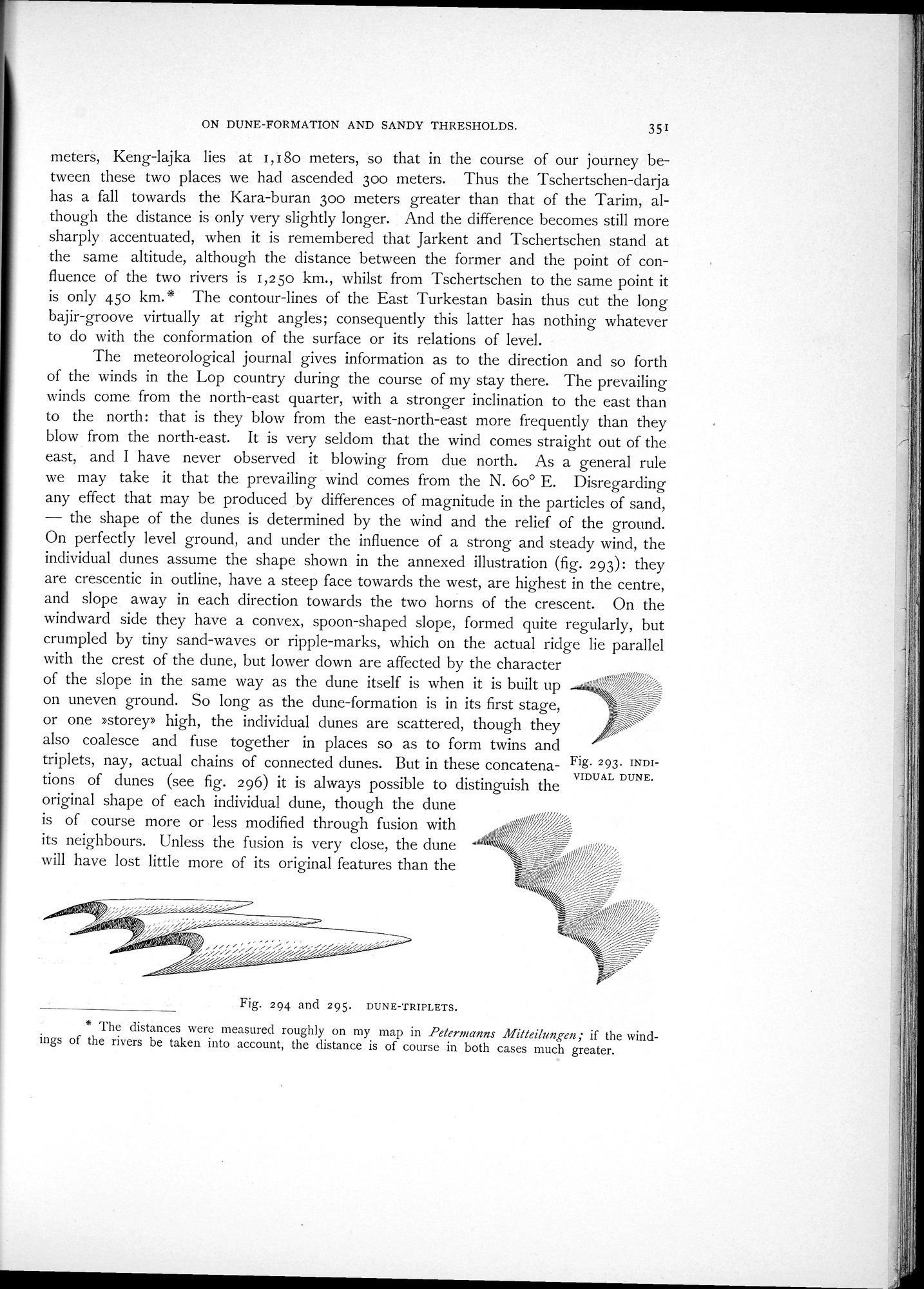
The meteorological journal gives information as to the direction and so forth of the winds in the Lop country during the course of my stay there. The prevailing winds come from the north-east quarter, with a stronger inclination to the east than to the north: that is they blow from the east-north-east more frequently than they blow from the north-east. It is very seldom that the wind comes straight out of the east, and I have never observed it blowing from due north. As a general rule we may take it that the prevailing wind comes from the N. 6o° E. Disregarding any effect that may be produced by differences of magnitude in the particles of sand, — the shape of the dunes is determined by the wind and the relief of the ground. On perfectly level ground, and under the influence of a strong and steady wind, the individual dunes assume the shape shown in the annexed illustration (fig. 293): they are crescentic in outline, have a steep face towards the west, are highest in the centre, and slope away in each direction towards the two horns of the crescent. On the windward side they have a convex, spoon-shaped slope, formed quite regularly, but crumpled by tiny sand-waves or ripple-marks, which on the actual ridge lie parallel with the crest of the dune, but lower down are affected by the character
of the slope in the same way as the dune itself is when it is built up on uneven ground. So long as the dune-formation is in its first stage,
or one »storey» high, the individual dunes are scattered, though they
also coalesce and fuse together in places so as to form twins and
triplets, nay, actual chains of connected dunes. But in these concatena- Fig. 293. INDI-
VIDUAL DUNE.
tions of dunes (see fig. 296) it is always possible to distinguish the original shape of each individual dune, though the dune is of course more or less modified through fusion with
its neighbours. Unless the fusion is very close, the dune~/r itï
will have lost little more of its original features than the z,, ,/~~~//;
Fig. 294 and 295. DUNE-TRIPLETS.
* The distances were measured roughly on my map in Petermanns Mitteilungen; if the windings of the rivers be taken into account, the distance is of course in both cases much greater.
|
Copyright (C) 2003-2019
National Institute of Informatics(国立情報学研究所)
and
The Toyo Bunko(東洋文庫). All Rights Reserved.
本ウェブサイトに掲載するデジタル文化資源の無断転載は固くお断りいたします。