National Institute of Informatics - Digital Silk Road Project
| |||||||||
|
| Scientific Results of a Journey in Central Asia, 1899-1902 : vol.2 |
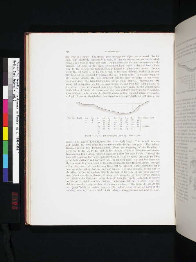 |
| Jurt-tschapghan, April 13. |
152 KARA-KOSCHUN.
the river in a canoe. The stream grew stronger the higher we advanced. Its left bank was plentifully supplied with reeds, so that we seldom saw the canals which break away from it along that part. On the same side too there are some tamarisk-mounds, but none on the right, or southern bank, which is flat and bare all the way to . the edge of the kamisch-beds, a distance of a few dozen meters. On the whole the left bank is the higher, as well as the more definitely marked of the two. On the right we observed five canals, the last of them called Tughdake-tschapghan, all entering marshes that are connected with the lakes we visited on our second excursion along the Kara-koschun (see the preceding chapter). Entering the sixth canal, Jol-tschapghan, we left the river behind us, and from that point paddled on the lakes. These are identical with those which I have called by the general name of the lakes of Abdal. On this occasion they were distinctly larger and more expanded than in 1896. In the vicinity of Kötschök-attamning-köli (Kutschuk-attam) we sounded a depth of 2.70 m., though there were stated to be greater depths on both sides of our
Fig. 96. Right. 0.32 0.36 2.33 3.62 4.7: 5.50 6.45 6.30 5.58 I.84 =depth. Left.
I 22 52 58 59 67 56 68 33
o 30 63 58 69 79 80 72 49 34 66 68 67 76 79 8o 4o 29 60 68 62 8i 8i 77 28 velocity.
42 62 62 62 79 83 84
38
J
Breadth = 42.4 in. Jurt-tschapghan, April 13. Scale z : 400.
route. The lake of Kajul (Karaul?)-köl is relatively large. This, as well as those just alluded to, have come into existence within the last two years. Then follows Kamuschluk-köli and Turkomaklik-köli. From the beginning of the Usun-köl, I perceived to the N. 33° E., and at the distance of two or three hundred meters, Kuntschekan Bek's Abdal, where I stayed for a time four years before. Although the huts still remained, they were surrounded on all sides by water. At length the lakes grew both shallower and narrower, and the kamisch came to an end, while here and there a tamarisk, growing, not on the usual mound, but upon the level ground, emerged above the water; it was between these that we paddled, except where the depth was so slight that we had to drag our canoes. The lake extended all the way to the village of Jurt-tschapghan, close to the wall of the fort. It was three years before (1897) that the inhabitants of Abdal were compelled by newly formed marshes and lakes, which threatened to cut them off from the road to Tscharklik, to remove to this place, and it was here that old Kuntschekan Bek died in 1898. Thus Ab-dal is a movable entity, a place of transitory existence. One hears of Kona-Abdals and Jangi-Abdals in various quarters; the oldest Abdal of all lies north of the existing waterway, on the bank of the Schirge-tschapghan arm and near its lakes.
|
Copyright (C) 2003-2019 National Institute of Informatics and The Toyo Bunko. All Rights Reserved.