National Institute of Informatics - Digital Silk Road Project
| |||||||||
|
| Scientific Results of a Journey in Central Asia, 1899-1902 : vol.2 |
 |
| The Tarim river from Lajlik to Jangi-köl. |
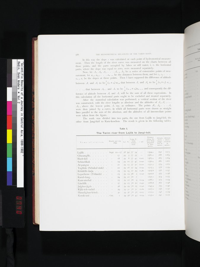
588 THE HYPSOMETRICAL. RELATIONS OF THE TARIM BASIN.
In this way the slope s was calculated at each point of hydrometrical measurement. Then the length of the river curve was measured on the charts between all those points, and the parts occupied by lakes or still water, i. e. the horizontal parts, where the slope was equal to zero, were measured separately.
Now, let Ai, A„ A3, . . . A„_1, A„ be a series of consecutive points of measurement, let al,,, a,,3, . . . ax_r,,, be the distances between them, and let s„ s„ . . . s„-x, s„, be the slopes at those points. Then. I have supposed the difference of altitude
between AI and A, to be- (s= + s,) aI,,, that between A, and A3 to be a (s, + s3) a,,3, . . . , that between A„_= and A„ to be 2 (s„,+ s„)a„_=, „, and consequently the dif-
ference of altitude between A= and A„ will be the sum of all these expressions. In this calculation all the horizontal parts ought to be excluded and treated separately.
After the numerical calculation was performed, a vertical section of the river was constructed, with the river lengths as abscissa and the altitudes of AI, A, , .. . A„_. above the lowest point, A„ say, as ordinates. The points AI, A„ . . . A„ were then joined by a curve, in which -all horizontal parts were drawn as straight lines parallel to the axis of the abscissa, and the altitudes of all intermediate points were taken from the figure.
The work was divided into two parts, the one from Lajlik to Jangi-köl, the other from Jangi-köl to Kara-koschun. The result is given in the following tables.
Table I.
The Tarim river from Lajlik to Jangi-köl.
Lal. N.
1
i Distance
Long. E. along the
from river from
Green- s • 10. Jangi-köl
wich. in kilo-
meters.
Altitude above Jangiköl in meters.
Altitude
above
sea-level
in
meters.
Name of station.
Month and day
1899.
Lajlik I Sept. 10-17 38° 59'
Ghasanglik » ► 7 39 3
Bisch-köl » 18 39 8
Schäschkak , » 19 39 10
At-pangsa » 21 39 13
Toghluk (Schakal-otak) » 22 39 18
Kötäklik-darja ; » 23 39 19
Lepscheme (Töländä) . ! » -23 39 19
Karul-dung » 24 39 22
Kum-atschal » 25 39 22
Läschlik » 27 39 23
Jalghus-jigde » 28 39 29
Kijik-tele-tschöl » 29 39 31
Haradighan-kötek . . . » 30 39 36
Kuruk-asti , Oct. 1 39 38.
I 173
I 169
1 164
1 162
I160 i
1159,
1157
.1156 1155 1154 1148 II,40
~
1137 ~ I129
I122
77' 34' -
77 35
77 43
77 47
77 51
77 54
77 59
78 3
78 7
78 9
78 20
78 25
78 31
78 36
78 43
1394.4 . 292
1381.2 288
0.267 1363.4 283
0.090 1350.4 281
0.110 1331.5 279
0.0S9 1315.3 278
0.380 1305.8 276
0.036 1300.8 275
1291.1 274
0.234 1286.7 273
0.452 1266.8 267
0.246 1245.9 259
0.181 I227.o 256
0.617 1210.o 248
0.154 1193.0 241
|
Copyright (C) 2003-2019 National Institute of Informatics and The Toyo Bunko. All Rights Reserved.