National Institute of Informatics - Digital Silk Road Project
| |||||||||
|
| Scientific Results of a Journey in Central Asia, 1899-1902 : vol.2 |
 |
| Tarim at Jurt-tschapghan, June 25. | |
| Veritcal section of Tarim at Jurt-tschapghan, April 3. |
158 KARA-KOSCHUN.
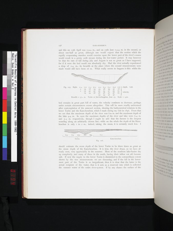
and this on 13th April was 0.6023 m., and on 25th June 0.3143 m. in the second, or about one-half as great, although one would expect that the suction which the rapidly evaporating marshes would exercise upon the lower part of the river's course would result in a pretty swift stream during the low-water period. It may however be that the rate of fall during July and August is not so great as I have supposed, for if it were the bed would run absolutely dry. Had the river actually experienced a drop of 2.55 m., its breadth at the place where the second measurements were made would still have been 26 m. What really seems to happen is this: whilst the
Fig. io5. Right. o.x2 1.88 3 02 3.84 4.50 5.52 5.97 5.98 2.88 = depth. Left.
15 28 33 33 38 39 32 18
23 30 32 39 34 41 39 19 velocity. 24 34 36 36 36 40 36 29
33 34 40 41
Breadth = 37.z m. Tarim at Jurt-tschapghan, June 25. Scale r : 400.
bed remains in great part full of water, the velocity continues to decrease, perhaps under certain circumstances ceases altogether. This will be more readily understood after contemplation of the annexed section, showing the bathymetrical relations in the lower Tarim and the Kara-koschun, which I made during my visit in 1896. From that we see that the maximum depth of the river was 8.8o In. and the maximum depth of the lake 4.25 m. In 1 goo the maximum depths of the river and lake were 6.45 m. and 5.15 m. respectively, though I ought to add that the former is the deepest sounding along an arbitrarily chosen line; while on the whole the depth of the Karakoschun is only 1 to 2 m., indeed, taking the mean, it is certainly much less. I
~ 4.85
4.25
7. es 6.03
'l'arim.
8.80 68o
Kara-koschun.
Fig. i 06.
should estimate the mean depth of the lower Tarim to be three times as great as the mean depth of the Kara-koschun. It is true, the river drops, as we have already seen, very appreciably in the summer. Most of the southern lake-basins dry up completely, and many of those in the north, having their inflow cut off, become salt. If now the supply to the lower Tarim is diminished to the extraordinary extent shown by the two measurements we are discussing, and if the fall in the lowermost part of the Tarim is so insignificant, then it is clear that the latter is the actual recipient of the water, that is it acts as a reservoir into which is collected the summer water of the entire river-system. If by any chance the surface of the
|
Copyright (C) 2003-2019 National Institute of Informatics and The Toyo Bunko. All Rights Reserved.