National Institute of Informatics - Digital Silk Road Project
| |||||||||
|
| Scientific Results of a Journey in Central Asia, 1899-1902 : vol.2 |
 |
| FORMATION OF RAMPARTS BESIDE THE TARIM. |
GENERAL CONCLUSIONS REGARDING THE KARA-KOSCI-IUN. 213
filled to such an extent with fluviatile sediment, that, high-water though it was, the canoes would scarcely float through it.
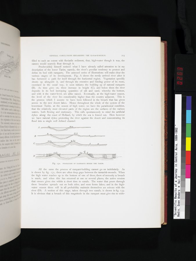
Prschevalskij himself noticed what I have already called attention to in my description of the lower Tarim, namely, the river's peculiar tendency to protect and define its bed with ramparts. The annexed series of illustrations will make clear the various stages of its development. Fig. A shows the newly arrived river after it has furrowed a path for itself through the horizontal region. Vegetation speedily shoots up alongside it, and through the retentive and binding power of its roots, exercised in the usual way, it soon initiates the building up of natural ramparts (B). As time goes on, these increase in height (C), and below them the river deposits in its bed increasing quantities of silt and sand, whereby the bottom, and with it the water-level, are alike raised. Eventually, at the high-water season, the level of the river lies considerably higher than the country adjacent. This is the process which I assume to have been followed in the breach that has given access to the new desert lakes. Hence throughout the whole of the system of the lowermost Tarim, at the season of high water, we have the paradoxical condition, that the relatively most elevated parts of the region are the surfaces of the various waters, both flowing and stationary. This calls spontaneously to mind the artificial dykes along the coast of Holland, by which the sea is fenced out. Here however we have natural dykes protecting the river against the desert and concentrating its flood into a single well defined channel.
Fig. 132. FORMATION OF RAMPARTS BESIDE THE TARIM.
All the same the process of rampart-building cannot go on indefinitely. As is shown by fig. 131, there are often deep gaps between the tamarisk-mounds. When the high water reaches up to the bottom of one of these, there of necessity a breach is made, and when this has occurred at one or several places, the active erosion that ensues gives rise within a short time to canals. The water that pours through these breaches spreads out on both sides, and soon forms lakes; and in the high-water season these will in all probability maintain themselves au niveau with the river (D). A section of this stage, taken through two canals, is shown in fig. 133• It is obvious that a breach of this magnitude in the rampart must give rise to wide-
A
|
Copyright (C) 2003-2019 National Institute of Informatics and The Toyo Bunko. All Rights Reserved.