National Institute of Informatics - Digital Silk Road Project
| |||||||||
|
| Scientific Results of a Journey in Central Asia, 1899-1902 : vol.2 |
 |
| Vertical section of depressions | |
| EAST SHORE OF ARKA-KÖL. VIEW LOOKING SOUTH, SHOWING SAND-DUNES PROCEEDING TOWARDS THE WEST ACROSS THE LAKE. IN THE MIDDLE DEAD FOREST; TO THE RIGHT FRESH VEGETATION ON THE VERY SHORE OF THE LAKE. |
GENERAL HYDROGRAPHICAL RELATIONS OF THE TARIM DELTAIC REGION. 343
narrow belt of land which separates the Ilek or Jangi-tarim from the lakes. Over against the Arka-köl this dividing strip of firm ground is 8 i o m. across, over against the Tajek-köl 7 to m., and over against the Kara-köl 4145 m. It is dotted over with numerous dunes, in great part overgrown with vegetation, and with tamarisk-mounds; but the original form of the sand-accumulations is exceptionally well preserved, especially in the locality last indicated (see vol. I., Pl. 55). The sand is disposed precisely as it is in the Desert of Tschertschen, highest in the west, though it decreases towards the east, until on the western shore of the Kara-köl there is none at all. As we travel up the Ilek, which is here a stream of some magnitude, we are at first inclined to think that these lakes are marginal lakes belonging to the river, but we soon discover that they have nothing whatever to do with it, but are nothing more nor less than a series of ancient bajir depressions which in quite recent times have become accidentally filled with water from the Bos-ilek.
d
8
:â
~
:Q
:°.
m
:Q v
~
F
_~
O.
W B
Fig. i66.
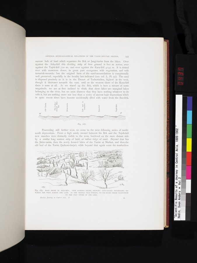
Proceeding still farther west, we come to the next following series of north-south depressions. From a high sandy mound between the Ilek and the Tajek-köl new marshes were distinctly visible to the west, bordered on the more distant side by a similar long narrow strip of land, or rather ridge of sand. Beyond that lies the Jätim-tarim, then the newly formed lakes of the Tarim at Markat, and then the old bed of the Tarim (Jarkent-darja); while beyond that again come the numberless
~~ ~~„~1/\l~• ~~(....y~••~~~ ~..~ 4 ..~. tWN~ÿ~~ r~.y1~~
~~ \ ~a•.rv
44S.
~ ~ ~• ~ ' ~ ~ . _ ~—r [ ~~~~_./._ ` E~ ` ~ v, I~ .~i~ï..~ /
,,.lC~p ` ~V - r~r i ~• ii.~~.- i
~ , ~,— i ~ ~ +-~~+~
;~~~ ~'~(~ .~ 1 ~ ~~ ~~
'~ ~ 1 ~~ . ~ _.~., , ~~r ~~,~ • ~ =~~ ~.
q ~~-.aft., ~Ld_ 1 ~ r' I i~ , ~~/ y` l ~ .~/i ~
Fig. i67. EAST SHORE OF ARKA-KÖL. VIEW LOOKING SOUTH, SHOWING SAND-DUNES PROCEEDING TO-
WARDS THE WEST ACROSS THE LAKE. IN THE MIDDLE DEAD FOREST; TO THE RIGHT FRESH VEGETATION
ON THE VERY SHORE OF THE LAKE.
Hed i n. `journey in Central Asia. II. 44
r' ~~ ' Srir~/ }~C1~JJ ~— ~ ' II ~ ~Nlr ~w.~~1',y~ ~.' ~c. ë1R~C`•6 -' ..~ ~ ` Î(C~ ~~ ~ ~~/11~. . r~t ~ :hjél~l! •~~
~( ~ ~~ t.
|
Copyright (C) 2003-2019 National Institute of Informatics and The Toyo Bunko. All Rights Reserved.