National Institute of Informatics - Digital Silk Road Project
| |||||||||
|
| Scientific Results of a Journey in Central Asia, 1899-1902 : vol.2 |
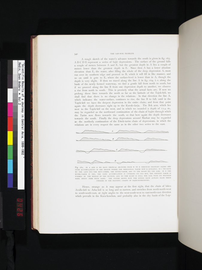 |
| IN A AND B WE HAVE VERTICAL SECTIONS FROM W TO E THROUGH ORDINARY BAJIRS AND DUNE ACCUMULATIONS IN THE REGION WHERE THE MERIDIONAL TARIM NOW IS SITUATED. IN C WE HAVE TO THE LEFT (W) THE NEW-COMER, THE ETTEK-TARIM, AND TO THE RIGHT (E) THE ILEK. IN D THE ETTEK-TARIM IS DRY, THE SAND ACCUMULATION IS COVERING ITS OLD BED, THE PRESENT TARIM IS FORMED IN THE MIDDLE OF THE SACTION. AND TO THE RIGHT IS STILL THE ILEK WITH ITS WESTERN COURSES IN THE EXISTING CHAINS OF BAJIR-DEPRESSIONS. |
340 THE LOP-NOR PROBLEM.
A rough sketch of the water's advance towards the south is given in fig. i 63. A B C D E represent a series of bajir depressions. The surface of the ground falls a couple of meters between A and E, but the greatest depth in A lies a couple of meters lower than the greatest depth in E. Since then A has a lower absolute elevation than E, the water, after filling the whole of the deep depression A, must run over its southern edge and proceed to B, which it will fill in like manner, and so on until it gets to E, where the surface-level is lower than in A, though the depth is very slight. If then we travel along the line A in fig. i 64, i. e. along the bank of the newly formed waterway, we find a gentle fall from north to south, but if we proceed along the line B from one depression depth to another, we observe a rise from north to south. This is precisely what the actual facts are. If now we prolong these lines towards the north as far as the latitude of the Tajek-köl, we shall find that there is no change in the relations. In that direction the line A, which indicates the water-surface, continues to rise, the line B to fall, until in the Tajek-köl we have the deepest depression in the entire chain; and from that point again the depth decreases right up to the Kuruk-darja. The Ilek arm, which lies next to the Tajek-köl on the west, and in which we sounded a depth of 12.55 m., may be regarded as the northward continuation of the chain of bajirs through which the Tarim now flows towards the south, so that here again the depth decreases towards the south. Finally the deep depressions around Markat may be regarded as the northerly continuation of the Ettek-tarim chain of depressions, in which the relations are in every respect the same as in the other two series to the east.
-.--
/// // A ~////////////1i..,~_ „iD///Uiliea,..a,,vaia,~,.,
///// P///i /iii ._C iii . —
| _ = D | |||
| |||
Fig. 162. IN A AND B WE HAVE VERTICAL SECTIONS FROM W TO E THROUGH ORDINARY BAJIRS AND DUNE ACCUMULATIONS IN THE REGION WHERE THE MERIDIONAL TARIM NOW IS SITUATED. IN C WE HAVE TO THE LEFT (W) THE NEW-COMER, THE ETTEK-TARIM, AND TO THE RIGHT (E) THE ILEK. IN D THE ETTEK-TARIM IS DRY, THE SAND ACCUMULATION IS COVERING ITS OLD BED, THE PRESENT TARIM IS FORMED IN THE MIDDLE OF THE SECTION, AND TO THE RIGHT IS STILL THE ILEK WITH ITS WESTERN BANK SWEPT FREE FROM SAND. THE FIGURE SHOWS HOW THE RIVERS HAVE ALWAYS MADE THEIR
COURSES IN THE EXISTING CHAINS OF BAJIR-DEPRESSIONS.
Hence, strange as it may appear at the first sight, that the chain of lakes Avullu-köl to Arka-köl is so long and so narrow, and stretches from north-north-west to south-south-east, at right angles to the west-south-west to east-north-east direction which prevails in the Kara-koschun, and probably also in the dry basin of the Lop-
|
Copyright (C) 2003-2019 National Institute of Informatics and The Toyo Bunko. All Rights Reserved.