国立情報学研究所 - ディジタル・シルクロード・プロジェクト
| |||||||||
|
| Results of a Scientific Mission to India and High Asia : vol.3 | |
| インドおよび高地アジアへの科学調査隊派遣の成果 : vol.3 |
 |
Niti, in Giirlival.
To face p. 31. Vol. III., part I.: Route-book.
Bâdrinath, in
Chilli, in Kânaur. Rim.
Gärhval. Him.
53 1-3-2
60 5.I 19 45 17 1 12
Samarkand, in Bokhâra.
Simla, 'in Simla. Halle.
SktIrdo, in Haiti. Tib..
Srinagar, in Kashmir. Him.
Sult*tnpur, in Kalu. Hinl. 34
T %shkencl, a Russ. cantonm. C As. 85 80
Élchi, in Turkistan. C. As.
Gangôtri, in Glirhval. G2rtok, in Gnarl Khôrsum.
Gilgit, in Gilgit. Tib
Kângra, in Chamba. Him. 48
Karakor tlm Pass, in Ladak. Tib. 44 42
Kârdong, in Lahill. Him. 28 l6 16
Kbshgar, in Turkistan. C. As.... 53. 25
Kokand, in Kdkand. C. As.
Leh, in Ladak. Tib. 61 39 14 14
NLirri, in Marri. Him. 24 85 63 34 38 20 33
56 27
47 .53 61 12 27 62 37
43 58
68 36 43 41 57 10 21 58
72 11 33 86 58 92 102 88 99 46
28 89 67 14 42 11 51 30 25
16 57 35 25 30 36. 12
15 76 54 25 29 20 81 59 6 34
65 14 26 79 51 95 54 .81 92 39
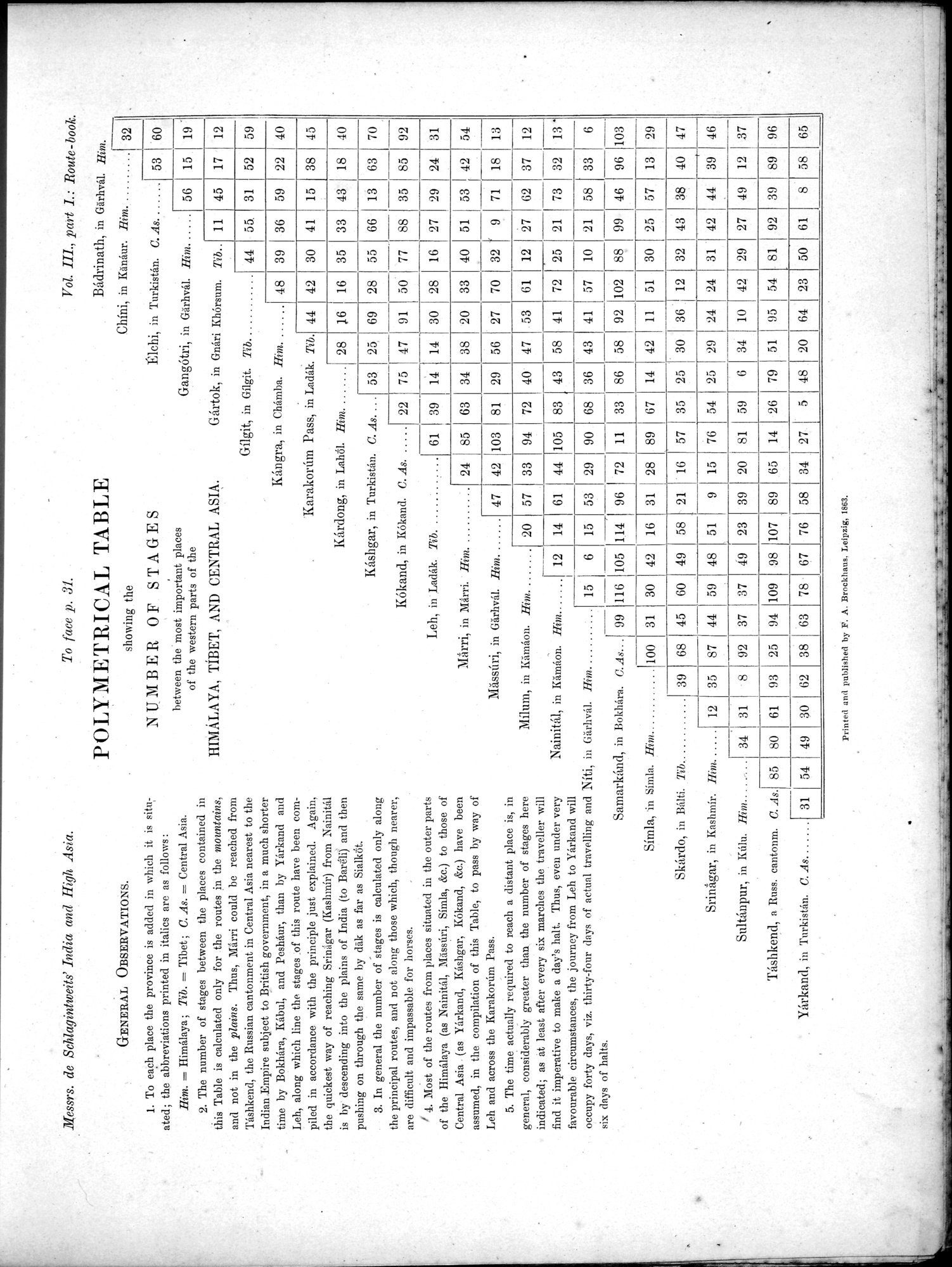
Iessrs. de Schlagintweits' India and High Asia.
GENERAL OBSERVATIONS.
To each place the province is added in which it is situated; the abbreviations printed in italics are as follows:
Rim. = Himalaya; Tib. = Tibet ; C. As. = Central Asia.
The number of stages between the places contained in this Table is calculated only for the routes in the mountains, and not in the plains. Thus, Marri could be reached from Tashkend, the Russian cantonment in Central Asia nearest to the Indian Empire subject to British government, in a much shorter time by Bokhâra, Kabul, and Peshaur, than by Yarkand and Leh, along which line the stages of this route have been compiled in accordance with the principle just explained. Again, the quickest way of reaching Srinagar (Kashmir) from Nainital is by descending into the plains of India (to Bareli) and then pushing on through the same by dàk as far as Sialkeit.
In general the number of stages is calculated only along the principal routes, and not along those which, though nearer, are difficult and impassable for horses.
Most of the routes from places situated in the outer parts of the Himalaya (as Nainital, Mässari, Simla, &c.) to those of Central Asia . (as Yarkand, Kashgar, Kokand, &c.) have been assumed, in the compilation of this Table, to pass by way of Leh and across the Karakoram Pass.
The time actually required to reach a distant place is, in general, considerably greater than. the number of stages here indicated; as at least after every six marches the traveller will find it imperative to make a day's halt. Thus, even under very favourable circumstances, the journey from Leh to Yarkand will occupy forty days, viz. thirty-four clays of actual travelling and six clays of halts.
POLYMETRICAL TABLE
showing the
NUMBER OF STAGES
between the most important places
of the western parts of the
HIMALAYA, TIBET, AND CENTRAL ASIA.
Milum, in Kämaon. Him. 20 57 33 94
Nainital, in Kämaon. Him. 12 14 61 44 105
15 6 15 53 29 90
C. As... 99 116 105 1.14 96
100 31 30 42 16 31
Mässtiri, in Giirhval. Him. 47 42 103 81
Hint
22
83
7
75
40
47
69 28 55 66
91 50 77 88
30 28 16 27
41
70
72
Him .
Tib..
44
35
40 51 53 42
30
36
33
55.
41
11
56
31
35I85
29 24
59
15
3 18
38
52
31 8 92 37 37
39 I 68 45 60 49 58 21
12 35 87 44 59 48 5
9 23 39
61 93 25 94 109
98 107 89
59
45
40
92
31
54
12
2 4
3 63 70
32 ( 9 71 18 13
25 21 73 32 13 '
33 6
96 103
13 29
89 96
54 49
38 63 78 ' 67 76 58 34 27. 5 48
23 50 61 8 58 65
24 24 31 42 44 39 46
10 42 29 27 49 12 .37
| 47 |
. Yirkand, in Turkistan. C. As
•
31
Printed and published by F. A. Brockhaus. Leipzig, 1863.
|
Copyright (C) 2003-2019
National Institute of Informatics(国立情報学研究所)
and
The Toyo Bunko(東洋文庫). All Rights Reserved.
本ウェブサイトに掲載するデジタル文化資源の無断転載は固くお断りいたします。