National Institute of Informatics - Digital Silk Road Project
| |||||||||
|
| Southern Tibet : vol.7 |
 |
~1
MY ROUTES ACROSS THE TRANSHIMALAYA.
547
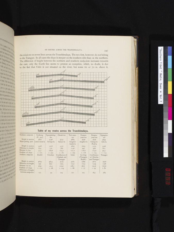
the relations on seven lines across the Transhimalaya. The two first, however, do not belong to the Tsangpo. In all cases the slope is steeper on the southern side than on the northern. The difference of height between the northern and southern endpoints increases towards the east; only the fourth line seems to present an exception, which, no doubt, is due to the fact that Ushü is not situated on the river, but some 6o or 7o m. above it.
•
•
•
•
•
•
•
•
•
•
•
•
•
•
Table of my routes across the Transhimalaya.
Chunit-tso
Northern endpoint
,r.
4747
Samye-la
Ngangtse- tso
4694
Sela-la
Dangrayum-tso
4646
Angden-la
Height in meters Water-parting pass
Nganglaring- tso
4746
Surnge-la
Gyäkung
(C. 241)
4802
Lamo-latse-la
5506 812 92,3 I:114
Tsangpo
5276
530
160,6
I : 303
Tokchen
Teri-nam- tso
4684
Sangmo-
bertik-la
5820
1136
I2I.2
I : 107
Ushü
5426
624
75,7
I:I2I Khaleb
Height in meters Difference in height Distance in km. Gradient of slope Southern endpoint
4654
622
4629
797
90,9
1:114
3930
1576
I27,0 I : 81
Dangra-
yum-tso
4646
Chang-la-
Pod-la
5572
926
125,0
i : 135
Confluence
of Dokchu and Tsangpo
4013
1559
145,0
I : 93
5643
997
I 16,o
I:I16
Le-lung
(Tsangpo;
Ryder)
4389
1254
96,0
I : 77
4563 1257 i08,1 I : 86
42,4 I .68
5527
780
125,7
I : 161
Confluence of
Chaktak and
Tsangpo
4524
1003
120,0
I : 119
~.
I2I
764
633
275
Height in meters Difference in height Distance in km. Gradient of slope Difference of height
between endpoints
223
173
92
■■
de~
~)
|
Copyright (C) 2003-2019 National Institute of Informatics and The Toyo Bunko. All Rights Reserved.