国立情報学研究所 - ディジタル・シルクロード・プロジェクト
| |||||||||
|
| Explorations in Turkestan 1903 : vol.1 | |
| トルキスタンの調査 1903年 : vol.1 |
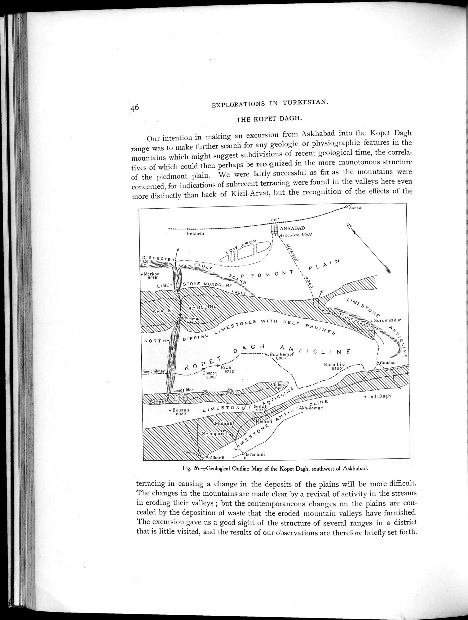 |
| コペトダクの地質学的概略図 アシハバードの南西Geological Outline Map of the Kopet Dagh, southwest of Askhabad. |
EXPLORATIONS IN TURKESTAN.
THE KOPET DAGH.
Our intention in making an excursion from Askhabad into the Kopet Dagh
range was to make further search for any geologic or physiographic features in the Ij
mountains which might suggest subdivisions of recent geological time, the correlatives of which could then perhaps be recognized in the more monotonous structure of the piedmont plain. We were fairly successful as far as the mountains were concerned, for indications of subrecent terracing were found in the valleys here even more distinctly than back of Kizil-Arvat, but the recognition of the effects of the
AS!<AßAD
I;c•r.men rtc.,ian, Well
IA CH \.;
//~
~Qi~! ; ~, \v.
; I
/ : = I~/ , ~c. N
DISSECTED ......................... Uú :; \o
111/1111107/" /illuu F,, .. ~ A t
r , ~
........... --- ~ P
+/Malirkou I"~•~\``IIJ////Illo///////^II!!//ij„~i,, S P I E D MO N T \`
soso' .=.,-..-,... . C ~~
_ \o
LIME^I' ~ STONE MONOCLINE
`N\\\\ FAULT " `''OS'~ ,
~ ~~~ ~ ~~ .♦ ~
', \-'\'\
cl Ai 4.. S/ro` \F/o1T
ti
<.a ~ gVCSl///+Su
rumuzdur
. NE5 W ITH pE c,/
/i
NORTH^~~ DIPPING /l/l/,,I/tii
46
H
A `
' ~ ~ —. G'—'~Bozikamof r I C L l N E !2
\8883' a:w~ rn O`\
?• ~ ! ~ ~•~ I 1
` P ~.~.-~- ~ Kara Iliki • 6~Gai:: m+
',. < K o Riza 830o at~
=_ _
Ko+ichikhar ~ Cha an 9732'N ~
~ ~ ._. — 93Ú0' ~ .~' N's‘–' i~~~~~
, . \\
^ ` ;Landslides \.~1~ ~~~` `
_ ; La , a~~~wà,w, .~~~~~~ ~ ~ w~r ~,~~, ~~~~
N~~~~~~\~ ~`.~~' ~~~~ ~~~,~`` ~ ~ ~ wQ•~,~~~ it , •~; ~~~ ~~~~~;\\\\t~.~ p N ~0,~
~~~ +Akl
~~ ~~j\~~â1,r``~+
i \ Mula`~``~i►'"`
\
\ ~
Fig. 26. Geological Outline Map of the Kopet Dagh, southwest of Askhabad.
terracing in causing a change in the deposits of the plains will be more difficult. The changes in the mountains are made clear by a revival of activity in the streams in eroding their valleys ; but the contemporaneous changes on the plains are concealed by the deposition of waste that the eroded mountain valleys have furnished. The excursion gave us a good sight of the structure of several ranges in a district that is little visited, and the results of our observations are therefore briefly set forth.
|
Copyright (C) 2003-2019
National Institute of Informatics(国立情報学研究所)
and
The Toyo Bunko(東洋文庫). All Rights Reserved.
本ウェブサイトに掲載するデジタル文化資源の無断転載は固くお断りいたします。