国立情報学研究所 - ディジタル・シルクロード・プロジェクト
| |||||||||
|
| Explorations in Turkestan 1903 : vol.1 | |
| トルキスタンの調査 1903年 : vol.1 |
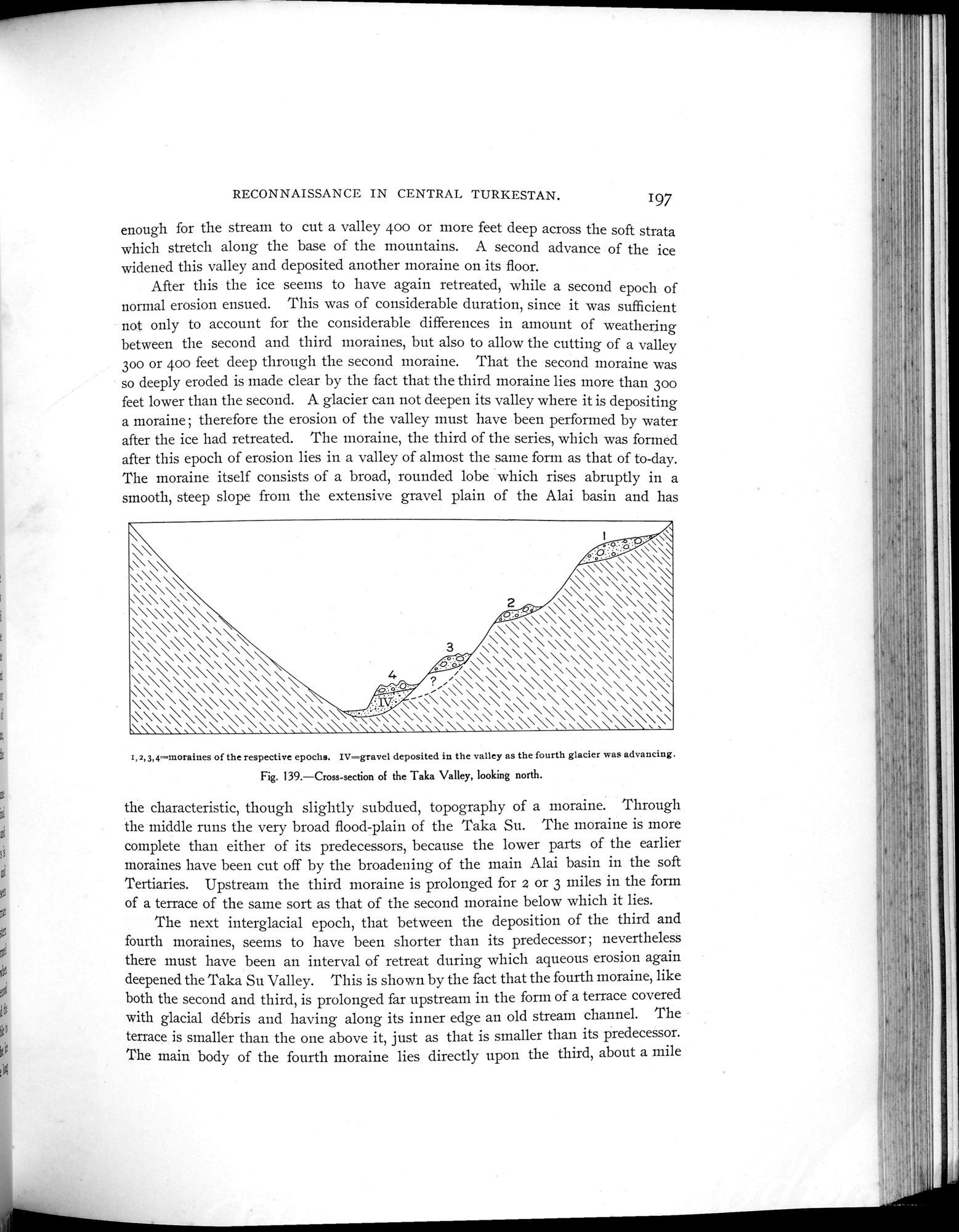 |
| タカ渓谷の断面 北向きCross-section of the Taka Valley, looking north. |
RECONNAISSANCE IN CENTRAI. TURKESTAN.
197
enough for the stream to cut a valley 400 or more feet deep across the soft strata which stretch along the base of the mountains. A second advance of the ice widened this valley and deposited another moraine on its floor.
After this the ice seems to have again retreated, while a second epoch of normal erosion ensued. This was of considerable duration, since it was sufficient not only to account for the considerable differences in amount of weathering between the second and third moraines, but also to allow the cutting of a valley 300 or 400 feet deep through the second moraine. That the second moraine was so deeply eroded is made clear by the fact that the third moraine lies more than 300 feet lower than the second. A glacier can not deepen its valley where it is depositing a moraine ; therefore the erosion of the valley must have been performed by water after the ice had retreated. The moraine, the third of the series, which was formed after this epoch of erosion lies in a valley of almost the same form as that of to-day. The moraine itself consists of a broad, rounded lobe which rises abruptly in a smooth, steep slope from the extensive gravel plain of the Alai basin and has
\\\\\\\\\\
\\ ~ \\
\\\\
°~-
\\ \\\ \\\\
\\\ \ \\~\\ \\\\
\\ 2 \\\\\\\
\\\\\~\\\ . . \\ k\\\ \\\\\ \\~ \\
\\ \\ \ \ \\ \\\\\\ ~ \ \\\
\\,\\\ \\\\ 3 \\\\\\\\\\\\\\\
\\ \\\\ o..-
\\\\\\\\\\\\\ \\\\\\\\\\\\\\\\\
\\\\\\\\\\ \ 4 ,..;/ \\\\\ \\ \\\\\\ \\
\\\ \ \\\\\ \\\ Ó.:~o.~~ ;\\\\\\\\\\\\\\\\\\'\\\\\\\\\\\\\\\\\\\`
\\\~\ \\\\\\\\ \\\\ ~~ \
\\\\\\\\\\\\\\\\ \\\\•\\ \\\\\\\\\\\\\ \\\\\\\\\\
r, 2,3,4—moraiues of the respective epochs. IV=gravel deposited in the valley as the fourth glacier was advancing. Fig. 139.—Cross-section of the Taka Valley, looking north.
the characteristic, though slightly subdued, topography of a moraine. Through the middle runs the very broad flood-plain of the Taka Su. The moraine is more complete than either of its predecessors, because the lower parts of the earlier moraines have been cut off by the broadening of the main Alai basin in the soft Tertiaries. Upstream the third moraine is prolonged for 2 or 3 miles in the form of a terrace of the same sort as that of the second moraine below which it lies.
The next interglacial epoch, that between the deposition of the third and fourth moraines, seems to have been shorter than its predecessor ; nevertheless there must have been an interval of retreat during which aqueous erosion again deepened the Taka Su Valley. This is shown by the fact that the fourth moraine, like both the second and third, is prolonged far upstream in the forni of a terrace covered with glacial débris and having along its inner edge an old stream channel. The terrace is smaller than the one above it, just as that is smaller than its predecessor. The main body of the fourth moraine lies directly upon the third, about a mile
|
Copyright (C) 2003-2019
National Institute of Informatics(国立情報学研究所)
and
The Toyo Bunko(東洋文庫). All Rights Reserved.
本ウェブサイトに掲載するデジタル文化資源の無断転載は固くお断りいたします。