国立情報学研究所 - ディジタル・シルクロード・プロジェクト
| |||||||||
|
| Explorations in Turkestan 1903 : vol.1 | |
| トルキスタンの調査 1903年 : vol.1 |
 |
| (東)クガルト(Kugart)渓谷の地滑りの10マイルの断面 北東向き 現在の川谷は砂利層が浸食されて水平になっており、これより古くて幅の広い、浸食されて傾斜した礫岩層が渓谷をふさいでいるTen-mile section of a Landslide in the (eastern) Kugart Valley, looking northeast. The present river valley is eroded in horizontal gravels that occupy an older and much wider valley eroded in tilted conglomerates. | |
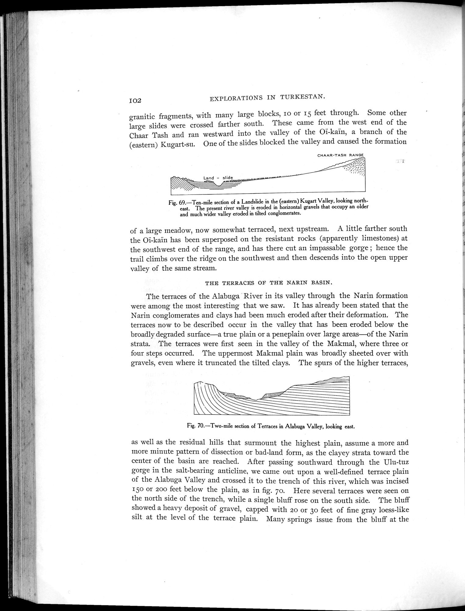
| Alabuga渓谷にある段丘の2マイルの断面 東向きTwo-mile section of Terraces in Alabuga Valley, looking east. |
| IO2 | EXPLORATIONS IN TURKESTAN. |
granitic fragments, with many large blocks, Io or 15 feet through. Some other large slides were crossed farther south. These came from the west end of the Chaar Tash and ran westward into the valley of the Oï-kaïn, a branch of the (eastern) Kugart-su. One of the slides blocked the valley and caused the formation
CHAAR-TASH RANGE
Fig. 69.—Ten-mile section of a Landslide in the (eastern) Kugart Valley, looking northeast. The present river valley is eroded in horizontal gravels that occupy an older and much wider valley eroded in tilted conglomerates.
of a large meadow, now somewhat terraced, next upstream. A little farther south the 01-kaïn has been superposed on the resistant rocks (apparently limestones) at the southwest end of the range, and has there cut an impassable gorge ; hence the trail climbs over the ridge on the southwest and then descends into the open upper valley of the same stream.
THE TERRACES OI THE NARIN BASIN.
The terraces of the Alabuga River in its valley through the Narin formation were among the most interesting that we saw. It has already been stated that the Narin conglomerates and clays had been much eroded after their deformation. The terraces now to be described occur in the valley that has been eroded below the broadly degraded surface—a true plain or a peneplain over large areas—of the Narin strata. The terraces were first seen in the valley of the Makmal, where three or four steps occurred. The uppermost Makmal plain was broadly sheeted over with gravels, even where it truncated the tilted clays. The spurs of the higher terraces,
Fig. 70.—Two-mile section of Terraces in Alabuga Valley, looking east.
as well as the residual hills that surmount the highest plain, assume a more and more minute pattern of dissection or bad-land form, as the clayey strata toward the center of the basin are reached. After passing southward through the Ulu-tuz gorge in the salt-bearing anticline, we came out upon a well-defined terrace plain of the Alabuga Valley and crossed it to the trench of this river, which was incised 15o or zoo feet below the plain, as in fig. 7o. Here several terraces were seen on the north side of the trench, while a single bluff rose on the south side. The bluff showed a heavy deposit of gravel, capped with 20 or 3o feet of fine gray loess-like silt at the level of the terrace plain. Many springs issue from the bluff at the
|
Copyright (C) 2003-2019
National Institute of Informatics(国立情報学研究所)
and
The Toyo Bunko(東洋文庫). All Rights Reserved.
本ウェブサイトに掲載するデジタル文化資源の無断転載は固くお断りいたします。