国立情報学研究所 - ディジタル・シルクロード・プロジェクト
| |||||||||
|
| Explorations in Turkestan 1903 : vol.1 | |
| トルキスタンの調査 1903年 : vol.1 |
 |
| Dungsugotの湖から山に至るShor Kul平原の南北の断面North and south section of the plain of Shor Kul from the lake to the mountains at Dungsugot. | |
| Dungsugotでシルトに入り込む渓谷の断面 解説は図146を参照Cross-section of a Valley cut in the silt at Dungsugot. For explanation see fig. 146. |
212 EXPLORATIONS IN TURKESTAN.
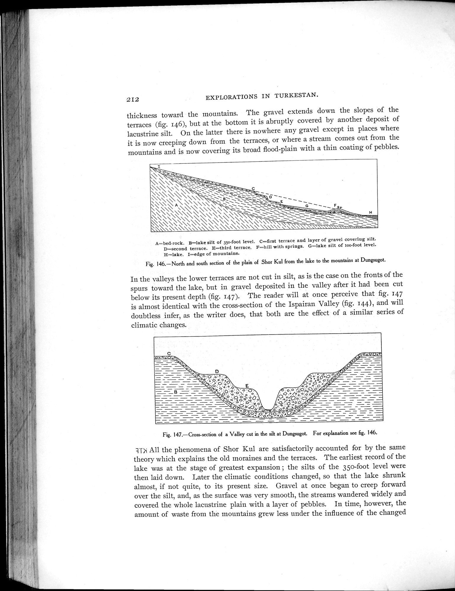
thickness toward the mountains. The gravel extends down the slopes of the terraces (fig. 146), but at the bottom it is abruptly covered by another deposit of lacustrine silt. On the latter there is nowhere any gravel except in places where it is now creeping down from the terraces, or where a stream comes out from the mountains and is now covering its broad flood-plain with a thin coating of pebbles.
A=bed-rock. B=lake silt of 35o-foot level. C=first terrace and layer of gravel covering silt. D=second terrace. $=third terrace. F=hill with springs. G=lake silt of roo-foot level. H =lake. I=edge of mountains.
Fig. 146.—North and south section of the plain of Shor Kul from the lake to the mountains at Dungsugot.
In the valleys the lower terraces are not cut in silt, as is the case on the fronts of the spurs toward the lake, but in gravel deposited in the valley after it had been cut below its present depth (fig. 147). The reader will at once perceive that fig. 147 is almost identical with the cross-section of the Ispairan Valley (fig. 144), and will doubtless infer, as the writer does, that both are the effect of a similar series of climatic changes.
Fig. 147.—Cross-section of a Valley cut in the silt at Dungsugot. For explanation see 6g. 146.
:n->i All the phenomena of Shor Kul are satisfactorily accounted for by the saine theory which explains the old moraines and the terraces. The earliest record of the lake was at the stage of greatest expansion ; the silts of the 35o-foot level were then laid down. Later the climatic conditions changed, so that the lake shrunk almost, if not quite, to its present size. Gravel at once began to creep forward over the silt, and, as the surface was very smooth, the streams wandered widely and covered the whole lacustrine plain with a layer of pebbles. In time, however, the amount of waste from the mountains grew less under the influence of the changed
z
.:,
\\ \\~,,';;;-.....
\\\\\\ \\\\\\\\\\~\\\:\ \\~\~\
\ \\\~~~_\~.\ \~
\\\\ ~
` \ \ \`..~
\\,~~~ .
\~~ \_`~~~` \
\•\\~\\\\\
\\\ , `~
\\\ \\\\ ;
\\•~\- • _`D
A \\\\
\\\\\\\\\~\\ \\\\\\\\\
~\\\\\\~\\\\\\\\\
H= =
|
Copyright (C) 2003-2019
National Institute of Informatics(国立情報学研究所)
and
The Toyo Bunko(東洋文庫). All Rights Reserved.
本ウェブサイトに掲載するデジタル文化資源の無断転載は固くお断りいたします。