国立情報学研究所 - ディジタル・シルクロード・プロジェクト
| |||||||||
|
| Explorations in Turkestan 1903 : vol.1 | |
| トルキスタンの調査 1903年 : vol.1 |
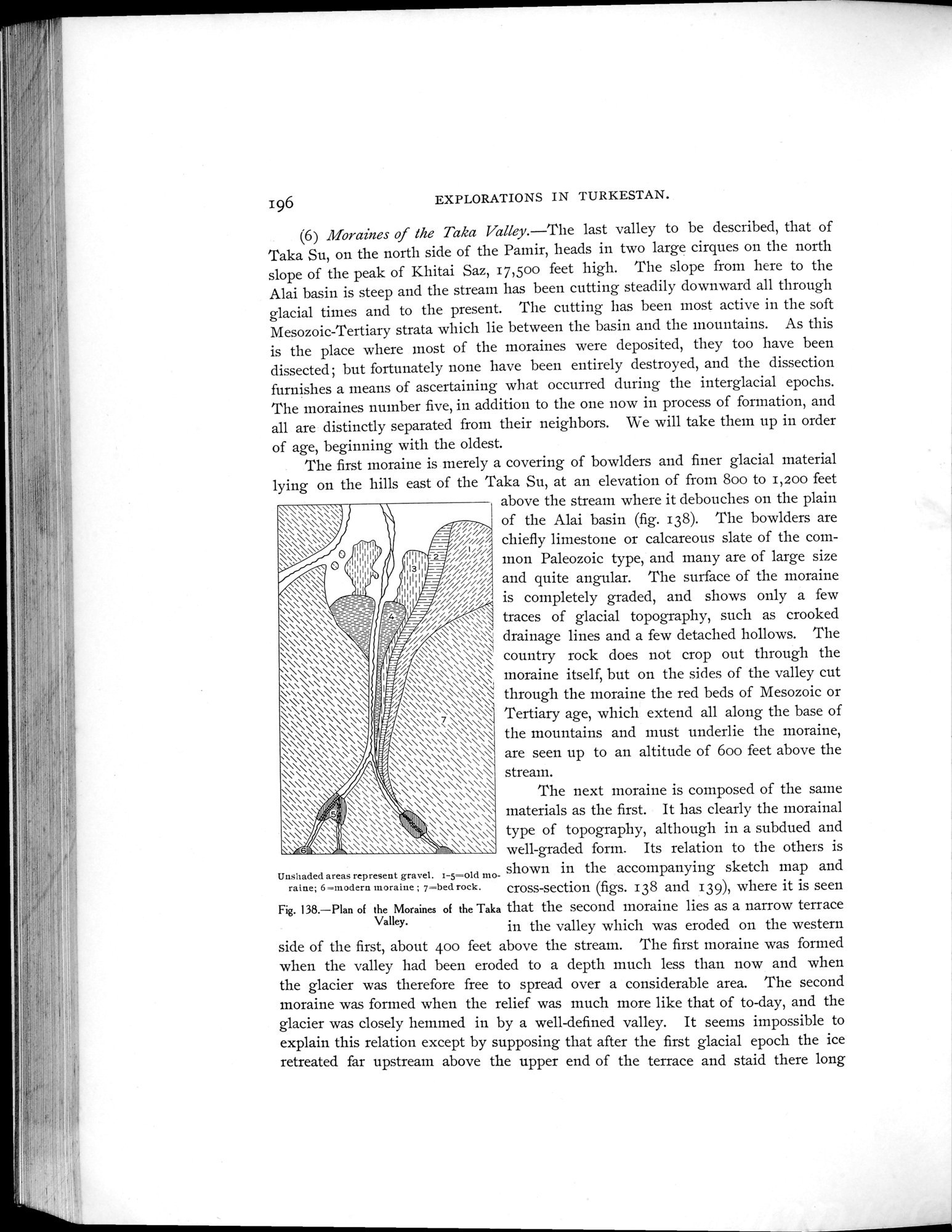 |
| タカ渓谷の氷堆積の平面図Plan of the Moraines of the Taka Valley. |
196 EXPLORATIONS IN TURKESTAN.
(6) Moraines of the Taka Valley.—The last valley to be described, that of Taka Su, on the north side of the Pamir, heads in two large cirques on the north slope of the peak of Khitai Saz, 17,50o feet high. The slope from here to the Alai basin is steep and the stream has been cutting steadily downward all through glacial times and to the present. The cutting has been most active in the soft Mesozoic-Tertiary strata which lie between the basin and the mountains. As this is the place where most of the moraines were deposited, they too have been dissected; but fortunately none have been entirely destroyed, and the dissection furnishes a means of ascertaining what occurred during the interglacial epochs. The moraines number five, in addition to the one now in process of formation, and all are distinctly separated from their neighbors. We will take them up in order
of age, beginning with the oldest.
The first moraine is merely a covering of bowlders and finer glacial material lying on the hills east of the Taka Su, at an elevation of from 800 to 1,20o feet `~~` above the stream where it debouches on the plain
\\\~~\\ ~\ • ~~ ,~,~ of the Alai basin (fig. 138). The bowlders are
~ / ;~~~~ c" '//// ! chiefly limestone or calcareous slate of the corn-
/mon Paleozoic type, and many are of large size /// *\;i~,(///iand quite angular. The surface of the moraine
, ~~l;~~s;///i~ is completely graded, and shows only a few
s w traces of lacial topography,such as crooked
A~ ~i~//\`~~~ ti glacial
"~~`~\`~4 s\k drainage lines and a few detached hollows. The
\\\~\\ ::::::k:\\"\~\~\~\\ country rock does not crop out through the
\\\\\ \``~\\\\ ~~moraine itself but on the sides of the valle cut
, ~\\,\\ \ \\ > Y\\\\\\`\\\ \~ thron h the moraine the red beds of Mesozoic or
\\\\\\~\ \\~\~ :\\~~~\\,\\\\:\\\\\\\\\\\\\~ Tertiary age, which extend all along the base of
\\,\;\\ \~\` \\\`\\ \~\ ~ the mountains and must underlie the moraine,
\\\\\\\\\\\ ~\~\~\\\\\ \\\\ are seen up to an altitude of 60o feet above the \\~\ ~\ `\\ \,...:,•\ ;~\ \\\`\\\\\\~~ stream.
..\\\\\\1~. k\ 4\\\ \~\\\\\\\ The next moraine is composed of the same
`\" ~~ pt r.11\\k~~ .qi\\\\\\\\\\\\\\\\\\\ materials as the first. It has clearly the morainal
~~ f `j ~`~~~~\k~~~i11ì~~~~i' t e of topography,although in a subdued and
~ \\ ~! ~~~~~\~\ \\~\\\ well-graded form. Its relation to the others is
Unshaded areas represent gravel. 1-5=old mo- shown in the accompanying sketch map and
raine; 6=modern moraine ; 7—bed rock. cross-section (figs. 138 and 139), where it is seen
Fig. 138.—Plan of the Moraines of the Taka that the second moraine lies as a narrow terrace
Valley. in the valley which was eroded on the western
side of the first, about 400 feet above the stream. The first moraine was formed when the valley had been eroded to a depth much less than now and when the glacier was therefore free to spread over a considerable area. The second moraine was formed when the relief was much more like that of to-day, and the glacier was closely hemmed in by a well-defined valley. It seems impossible to explain this relation except by supposing that after the first glacial epoch the ice retreated far upstream above the upper end of the terrace and staid there long
|
Copyright (C) 2003-2019
National Institute of Informatics(国立情報学研究所)
and
The Toyo Bunko(東洋文庫). All Rights Reserved.
本ウェブサイトに掲載するデジタル文化資源の無断転載は固くお断りいたします。