国立情報学研究所 - ディジタル・シルクロード・プロジェクト
| |||||||||
|
| Explorations in Turkestan 1903 : vol.1 | |
| トルキスタンの調査 1903年 : vol.1 |
 |
| Alabuga川とナリン川の接合部にある段丘の3マイルの断面 東向きThree-mile section of Terraces at the junction of the Alabuga and Narin Rivers, looking east. |
ORIGIN OF TIIE TERRACES.
surface of contact of the gravels on the Narin clays. The river is now so rapid that it washes along heavy cobbles. A much gentler current is suggested by the silts that cap the gravel bluff.
As the Alabuga is followed eastward, a graded plain makes its appearance 300 or 400 feet above the terraces just mentioned. It is this higher plain which constitutes the peneplain, worn on the disturbed Narin formation. Bad-land residuals, zoo or 200 feet in height, still surmount it here and there ; yet in the district where the road crossed over its remnant spurs, the peneplain must have occupied nine-tenths of the basin floor south of the river before the present valleys were cut below it. The peneplain here is cloaked with from 3o to 5o feet of gravel, which lies unconformably on the beveled surface of the tilted clays. At some points a heavier brown conglomerate is locally developed at the base of the gravels, as if it were the channel fillings of a river. Its outcrops are rather strong, and large blocks from it creep down the clay slopes beneath.
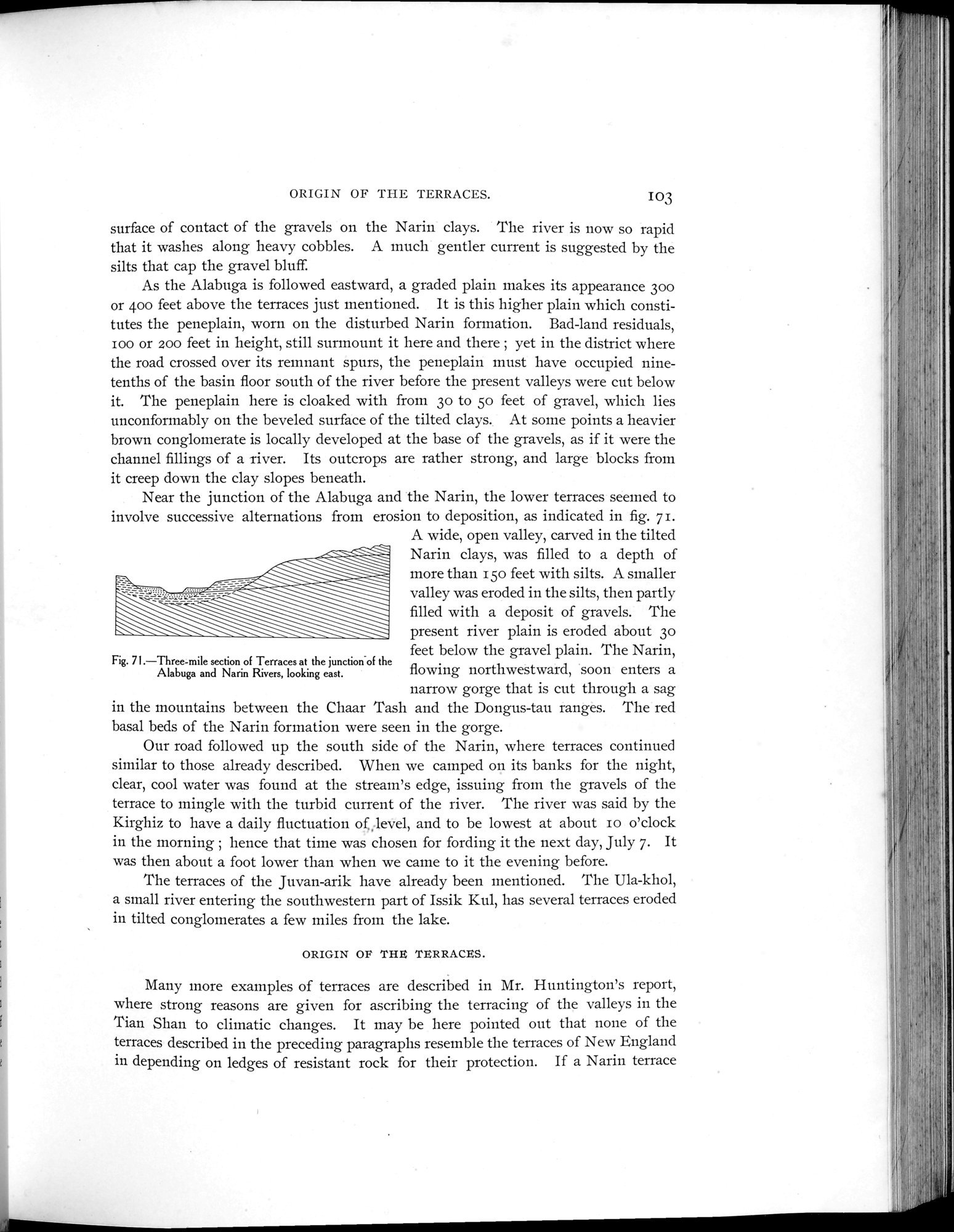
Near the junction of the Alabuga and the Narin, the lower terraces seemed to involve successive alternations from erosion to deposition, as indicated in fig. 71.
A wide, open valley, carved in the tilted Narin clays, was filled to a depth of more than 150 feet with silts. A smaller valley was eroded in the silts, then partly filled with a deposit of gravels. The present river plain is eroded about 3o
feet below the gravel plain. The Narin,
Fig. 71.—Three-mile section of Terraces at the junction-of the
Alabuga and Narin Rivers, looking east. flowing northwestward, soon enters a
narrow gorge that is cut through a sag in the mountains between the Chaar Tash and the Dongus-tau ranges. The red basal beds of the Narin formation were seen in the gorge.
Our road followed up the south side of the Narin, where terraces continued similar to those already described. When we camped on its banks for the night, clear, cool water was found at the stream's edge, issuing from the gravels of the terrace to mingle with the turbid current of the river. The river was said by the Kirghiz to have a daily fluctuation of., level, and to be lowest at about ro o'clock in the morning ; hence that time was chosen for fording it the next day, July 7. It was then about a foot lower than when we came to it the evening before.
The terraces of the Juvan-arik have already been mentioned. The Ula-khol, a small river entering the southwestern part of Issik Kul, has several terraces eroded in tilted conglomerates a few miles from the lake.
ORIGIN OF THE TERRACES.
Many more examples of terraces are described in Mr. Huntington's report, where strong reasons are given for ascribing the terracing of the valleys in the Tian Shan to climatic changes. It may be here pointed out that none of the terraces described in the preceding paragraphs resemble the terraces of New England in depending on ledges of resistant rock for their protection. If a Narin terrace
I 03
|
Copyright (C) 2003-2019
National Institute of Informatics(国立情報学研究所)
and
The Toyo Bunko(東洋文庫). All Rights Reserved.
本ウェブサイトに掲載するデジタル文化資源の無断転載は固くお断りいたします。