国立情報学研究所 - ディジタル・シルクロード・プロジェクト
| |||||||||
|
| Explorations in Turkestan 1903 : vol.1 | |
| トルキスタンの調査 1903年 : vol.1 |
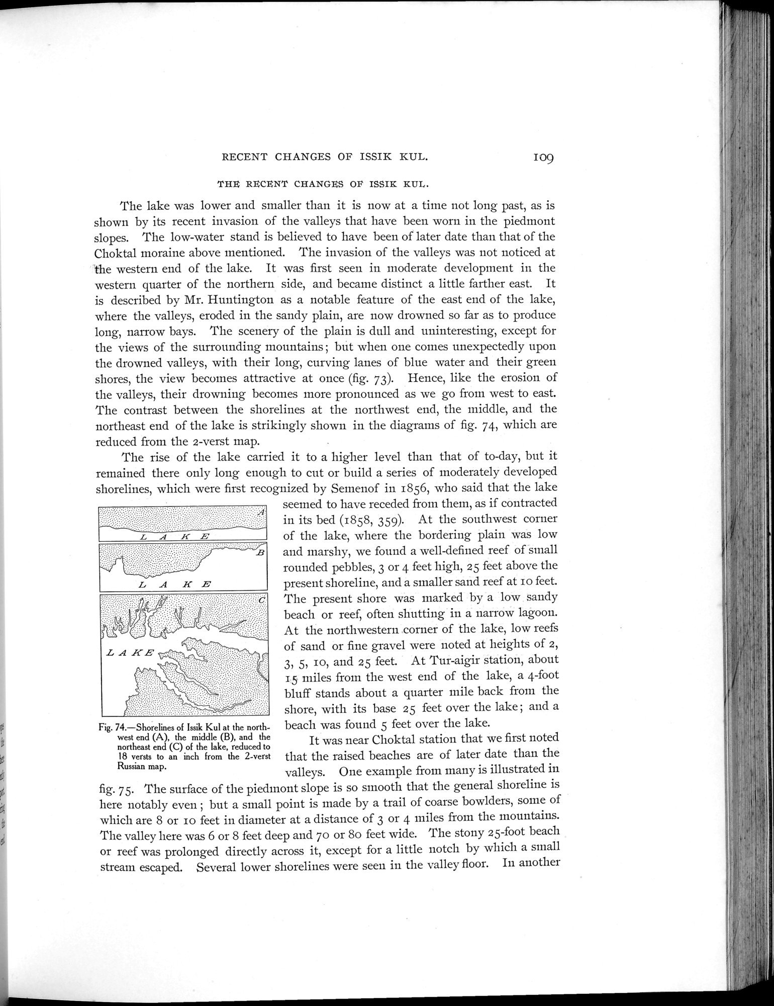 |
| イシククル湖の北西の端(A) 中央(B) 北東の端の汀線 2ベルスタのロシア地図が18ベルスタ~1インチに縮小したShorelines of Issik Kul at the northwest end (A), the middle (B), and the northeast end (C) of the lake, reduced to 18 versts to an inch from the 2-verst Russian map. |
RECENT CHANGES OF ISSIK KUL. 109
THE RECENT CHANGES OF ISM KUL.
The lake was lower and smaller than it is now at a time not long past, as is shown by its recent invasion of the valleys that have been worn in the piedmont slopes. The low-water stand is believed to have been of later date than that of the Choktal moraine above mentioned. The invasion of the valleys was not noticed at the western end of the lake. It was first seen in moderate development in the western quarter of the northern side, and became distinct a little farther east. It is described by Mr. Huntington as a notable feature of the east end of the lake, where the valleys, eroded in the sandy plain, are now drowned so far as to produce long, narrow bays. The scenery of the plain is dull and uninteresting, except for the views of the surrounding mountains ; but when one comes unexpectedly upon the drowned valleys, with their long, curving lanes of blue water and their green shores, the view becomes attractive at once (fig. 73). Hence, like the erosion of the valleys, their drowning becomes more pronounced as we go from west to east. The contrast between the shorelines at the northwest end, the middle, and the northeast end of the lake is strikingly shown in the diagrams of fig. 74, which are reduced from the 2-verst map.
The rise of the lake carried it to a higher level than that of to-day, but it remained there only long enough to cut or build a series of moderately developed shorelines, which were first recognized by Semenof in 1856, who said that the lake
seemed to have receded from them, as if contracted in its bed (1858, 359). At the southwest corner of the lake, where the bordering plain was low and marshy, we found a well-defined reef of small rounded pebbles, 3 or 4 feet high, 25 feet above the present shoreline, and a smaller sand reef at io feet. The present shore was marked by a low sandy beach or reef, often shutting in a narrow lagoon. At the northwestern corner of the lake, low reefs of sand or fine gravel were noted at heights of 2, 3, 5, IO, and 25 feet. At Tur-aigir station, about 15 miles from the west end of the lake, a 4-foot bluff stands about a quarter mile back from the shore, with its base 25 feet over the lake ; and a
Fig. 74.—Shorelines of Issik Kul at the north- beach was found 5 feet over the lake.
west end (A), the middle (B), and the It was near Choktal station that we first noted
northeast end (C) of the lake, reduced to
18 versts to an inch from the 2-verst that the raised beaches are of later date than the Russian map.
valleys. One example from many is illustrated
m in
fig. 75. The surface of the piedmont slope is so smooth that the general shoreline is here notably even ; but a small point is made by a trail of coarse bowlders, some of which are 8 or io feet in diameter at a distance of 3 or 4 miles from the mountains. The valley here was 6 or 8 feet deep and 70 or 8o feet wide. The stony 25-foot beach or reef was prolonged directly across it, except for a little notch by which a small stream escaped. Several lower shorelines were seen in the valley floor. In another
|
Copyright (C) 2003-2019
National Institute of Informatics(国立情報学研究所)
and
The Toyo Bunko(東洋文庫). All Rights Reserved.
本ウェブサイトに掲載するデジタル文化資源の無断転載は固くお断りいたします。