国立情報学研究所 - ディジタル・シルクロード・プロジェクト
| |||||||||
|
| Explorations in Turkestan 1903 : vol.1 | |
| トルキスタンの調査 1903年 : vol.1 |
 |
| シスタン湖の北西岸の湖段丘と断崖の典型的な断面Ideal Cross-section of the Lake Terraces and Bluffs of the Northwest Shore of the Lake of Sistan. |
294 THE BASIN OF EASTERN PERSIA AND SISTAN.
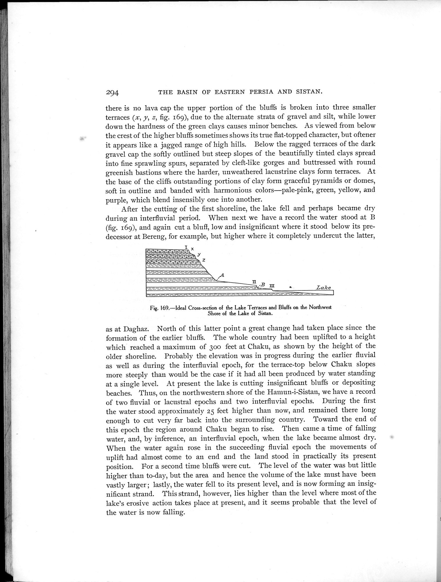
there is no lava cap the upper portion of the bluffs is broken into three smaller terraces (x, y, z, fig. 169), due to the alternate strata of gravel and silt, while lower down the hardness of the green clays causes minor benches. As viewed from below the crest of the higher bluffs sometimes shows its true flat-topped character, but oftener it appears like a jagged range of high hills. Below the ragged terraces of the dark gravel cap the softly outlined but steep slopes of the beautifully tinted clays spread into fine sprawling spurs, separated by cleft-like gorges and buttressed with round greenish bastions where the harder, unweathered lacustrine clays form terraces. At the base of the cliffs outstanding portions of clay form graceful pyramids or domes, soft in outline and banded with harmonious colors—pale-pink, green, yellow, and purple, which blend insensibly one into another.
After the cutting of the first shoreline, the lake fell and perhaps became dry during an interfluvial period. When next we have a record the water stood at B (fig. 169), and again cut a bluff, low and insignificant where it stood below its predecessor at Bereng, for example, but higher where it completely undercut the latter,
1
.o-°DdëR•:: e..ë?.ïai~.
,.PV~lt°:ó;~.öo.ë0: e'o:O~ë°ëI°.:6•°.:e,°..
Lake
Fig. 169.—Ideal Cross-section of the Lake Terraces and Bluffs on the Northwest
Shore of the Lake of Sistan.
as at Daghaz. North of this latter point a great change had taken place since the formation of the earlier bluffs. The whole country had been uplifted to a height which reached a maxitnum of 30o feet at Chaku, as shown by the height of the older shoreline. Probably the elevation was in progress during the earlier fluvial as well as during the interfluvial epoch, for the terrace-top below Chaku slopes more steeply than would be the case if it had all been produced by water standing at a single level. At present the lake is cutting insignificant bluffs or depositing beaches. Thus, on the northwestern shore of the Hamun-i-Sistan, we have a record of two fluvial or lacustral epochs and two interfluvial epochs. During the first the water stood approximately 25 feet higher than now, and remained there long enough to cut very far back into the surrounding country. Toward the end of this epoch the region around Chaku began to rise. Then came a time of falling water, and, by inference, an interfluvial epoch, when the lake became almost dry. When the water again rose in the succeeding fluvial epoch the movements of uplift had almost corne to an end and the land stood in practically its present position. For a second time bluffs were cut. The level of the water was but little higher than to-day, but the area and hence the volume of the lake must have been vastly larger ; lastly, the water fell to its present level, and is now forming an insignificant strand. This strand, however, lies higher than the level where most of the lake's erosive action takes place at present, and it seems probable that the level of the water is now falling.
|
Copyright (C) 2003-2019
National Institute of Informatics(国立情報学研究所)
and
The Toyo Bunko(東洋文庫). All Rights Reserved.
本ウェブサイトに掲載するデジタル文化資源の無断転載は固くお断りいたします。