National Institute of Informatics - Digital Silk Road Project
| |||||||||
|
| Explorations in Turkestan 1903 : vol.1 |
 |
| Effect of tilting on an inclosed lake; uplift on the right. | |
| Effect of tilting on an inclosed lake; uplift on the left. |
EXPLORATIONS IN TURKESTAN.
occupies about two-fifths of the total area of its catchment basin, the upper Chu basin not included. The surrounding mountains, from which most of the water supply is received, probably occupies as much surface as the lake, leaving one-fifth of the catchment basin as valleys and piedmont slopes. The drainage basin of the upper Chu system, southwest from the lake, is in area about a quarter of the present Issik Kul basin, or roughly a half of the mountain area that drains into the lake. Inasmuch as the chief upper branches of the Chu, the Kach-kar and the Juvanarik, come from among high ranges, it is evident that their volume must be a considerable fraction of the total water supply that the lake now receives ; not, however, so large a fraction as their drainage area would suggest, for the mountains southeast of Issik Kul are lofty, and we were told that many large streams flow from them. If liberal allowance be made for this, the upper Chu might be taken as yielding perhaps a twentieth of the present supply of Issik Kul ; hence if the upper Chu were turned into the lake, its surface ought to expand by a twentieth part, if it did not overflow to the lower Chu before such an expansion was accomplished.
On the other hand, when the lake stood at the 25-foot shoreline, its area could hardly have been increased by a twentieth of its present surface. Hence it is probable that if the Chu should now be turned into the lake, its surface would rise to the 25-foot shoreline, if a barrier of that height existed at the outlet ; and there
might be some water to spare for overflow. It has already been shown that the delta-like plains between the Chu and the western end of Issik Kul indicate that the river has entered the lake. Evidence will now be presented to show that an overflowing outlet has probably generally existed during the subrecent history of
the lake. This evidence is found first, in the eastward Fig. Effect of tilting on an in-
> > closseedd l lake; uplift on the right.
increase in the depth of valley erosion, and, second, in
the eastward increase in the depth of valley drowning, already stated. To appreciate this curious case, a preliminary statement will be serviceable.
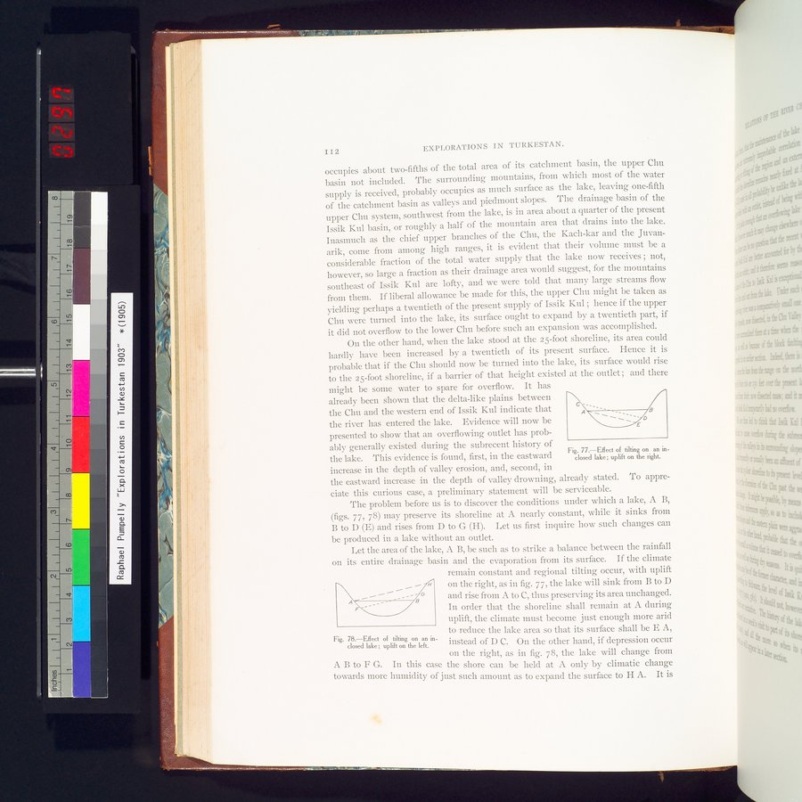
The problem before us is to discover the conditions under which a lake, A B, (figs. 77, 78) may preserve its shoreline at A nearly constant, while it sinks from B to D (E) and rises from D to G (H). Let us first inquire how such changes can be produced in a lake without an outlet.
Let the area of the lake, A B, be such as to strike a balance between the rainfall on its entire drainage basin and the evaporation from its surface. If the climate
remain constant and regional tilting occur, with uplift on the right, as in fig. 77, the lake will sink from B to D
and rise from A to C, thus preserving its area unchanged. In order that the shoreline shall remain at A during uplift, the climate must become just enough more arid to reduce the lake area so that its surface shall be E A,
Fig. 78.—Effect of tilting on an in- instead of D C. On the other hand, if depression occur
closed lake; uplift on the left. >
on the right, as in fig. 78, the lake will change from A B to F G. In this case the shore can be held at A only by climatic change towards more humidity of just such amount as to expand the surface to H A. It is
II2
|
Copyright (C) 2003-2019 National Institute of Informatics and The Toyo Bunko. All Rights Reserved.