National Institute of Informatics - Digital Silk Road Project
| |||||||||
|
| Explorations in Turkestan 1903 : vol.1 |
 |
| Longitudinal section of the Khoja Ishken or Kok Su Valley. |
| RECONNAISSANCE IN CENTRAL TURKESTAN. | 187 |
moraines grow fresher and younger in form from the lowest to the highest; and a long interval must have elapsed between the formation of No. i and No. 5. From the evidence supplied by other valleys it seems that each moraine represents an advance of the ice after a considerable retreat; so far as the Jukuchak Valley is concerned, however, the ice might simply have retreated by successive steps and the intervals between the steps need not have been of great length.
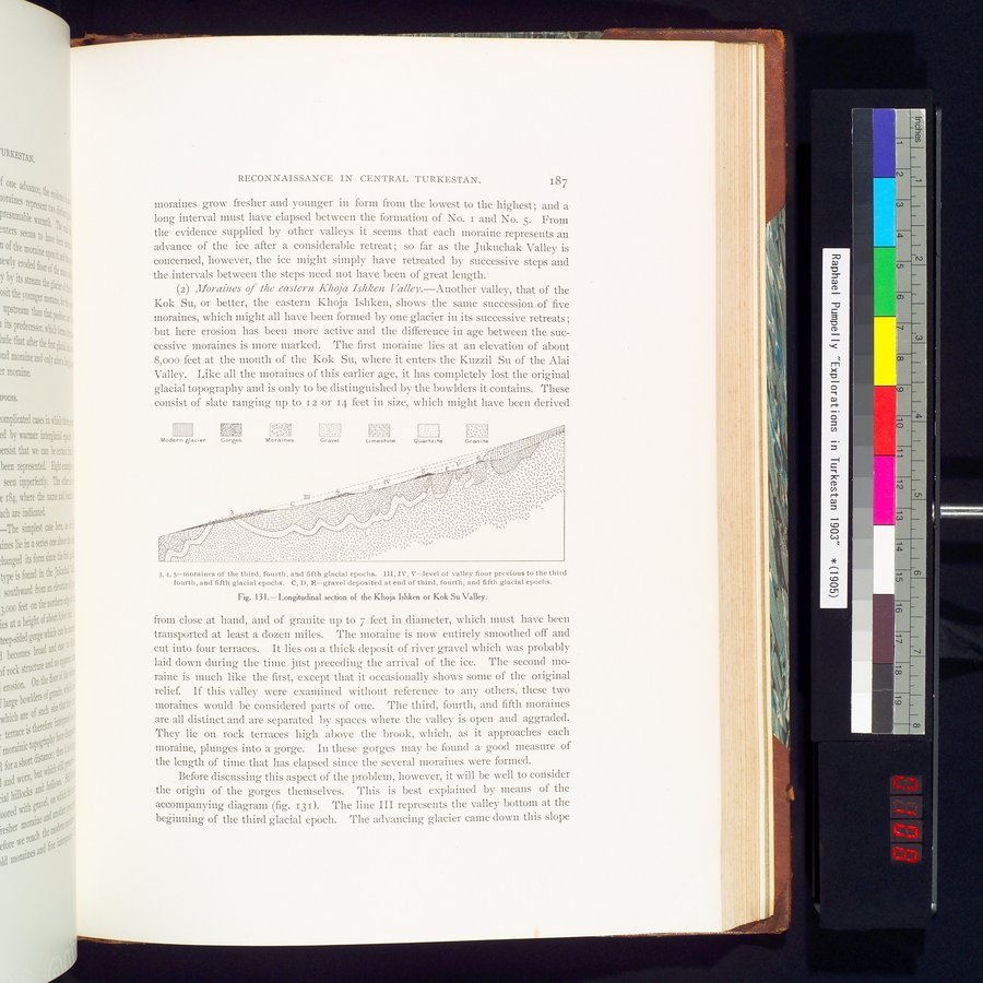
(2) Moraines of the eastern Khoja Ishken Valley.—Another valley, that of the Kok Su, or better, the eastern Khoja Ishken, shows the same succession of five moraines, which might all have been formed by one glacier in its successive retreats; but here erosion has been more active and the difference in age between the successive moraines is more marked. The first moraine lies at an elevation of about 8,000 feet at the mouth of the Kok Su, where it enters the Kuzzil Su of the Alai Valley. Like all the moraines of this earlier age, it has completely lost the original glacial topography and is only to be distinguished by the bowlders it contains. These consist of slate ranging up to 12 or 14 feet in size, which might have been derived
3.4.5—moraines of the third, fourth, and fifth glacial epochs. III, IV, V=level of valley floor previous to the third
fourth, and fifth glacial epochs. C, D, $=gravel deposited at end of third, fourth, and fifth glacial epochs.
Fig. 131.— Longitudinal section of the Khoja Ishken or Kok Su Valley.
from close at hand, and of granite up to 7 feet in diameter, which must have been transported at least a dozen miles. The moraine is now entirely smoothed off and cut into four terraces. It lies on a thick deposit of river gravel which was probably laid down during the time just preceding the arrival of the ice. The second moraine is much like the first, except that it occasionally shows some of the original relief. If this valley were examined without reference to any others, these two moraines would be considered parts of one. The third, fourth, and fifth moraines are all distinct and are separated by spaces where the valley is open and aggraded. They lie on rock terraces high above the brook, which, as it approaches each moraine, plunges into a gorge. In these gorges may be found a good measure of the length of time that has elapsed since the several moraines were formed.
Before discussing this aspect of the problem, however, it will be well to consider the origin of the gorges themselves. This is best explained by means of the accompanying diagram (fig. 131). The line III represents the valley bottom at the beginning of the third glacial epoch. The advancing glacier came down this slope
III II I 1
Modern glacier
Gorges
Moraine&
Gravel
l.i maetone
. ::-:j
Quartzite
Granite
c
ifi:~t
~~' ..
--.$=- -, =~=~%~
"•4~.'.~~'"_'~~i~/~%i~\I%~G:I~.-~.'\~\liti~Ì~Ì~ 1
~tí.~~~t—,
III^~'~•:.'s -I~-:..d .•., .•~1
~ Ç,, i~ • ~ii~ ~: iÌ~,~~PIlI~:;•'~':•'.`i~í~~\,~:~i: ~i~:`I.~`~~
~C ji ~°~i/~ ~IU~~2v t,.t `_t /~ i /1—
••:~i`~i\`~~~~\
:: •i~~i
r
v.
|
Copyright (C) 2003-2019 National Institute of Informatics and The Toyo Bunko. All Rights Reserved.