National Institute of Informatics - Digital Silk Road Project
| |||||||||
|
| Explorations in Turkestan 1903 : vol.1 |
 |
| North and south section along the Heri Rud at Pul-i-Khatun. Cretaceous limestone. | |
| North and south section along the Heri Rud at Pul-i-Khatun. Tertiary brown limestone. | |
| North and south section along the Heri Rud at Pul-i-Khatun. Tertiary brown sandstone. | |
| North and south section along the Heri Rud at Pul-i-Khatun. Tertiary thin clayey limestone. | |
| North and south section along the Heri Rud at Pul-i-Khatun. Tertiary soft sandstone. | |
| North and south section along the Heri Rud at Pul-i-Khatun. Tertiary impure yellow limestone. | |
| North and south section along the Heri Rud at Pul-i-Khatun. Tertiary reddish-brown sandstone. | |
| North and south section along the Heri Rud at Pul-i-Khatun. Tertiary white limestone. |
238 THE BASIN OF EASTERN PERSIA AND SISTAN.
(pp. 133-134) speaks of the " soft-sided " hills as being worn away so fast that " the mountains ran down to the plains in rivulets of mud." Because of this rapid process of degradation the mountains north of Herat " are certainly not such as were described by classical writers two thousand years ago." The wonderful rapidity of erosion is illustrated by a story related by Holdich (p. 135) of a place in this region where the hilltops consisted of a stratified, somewhat loess-like formation of recent date. In descending from the top of a hill during " quite an ordinary hailstorm
. . I was up to my knees in a moving mass of liquid liiud. . . . By evening that mud had spread out in a thin but very measurable sheet of surface soil far over the plains all around the hill ; and the hill was definitely smaller and the plains definitely higher than they had been the day previous." It is possible that the region is as young in years as Kopet Dagli, although the topography is mature by reason of the softness of the strata.
A section along the Heri Rud from Serakhs southward leads to the saine conclusion. At first the stream flows in a terraced valley intrenched some 20 or 3o feet below the alluvial plain which stretches indefinitely northward. Toward the south, however, it traverses a region of low hills composed of an alluvial deposit, which seems to be of the saine character as the plain and as the deposits which are now being laid down by the river, although older than either. Where exposed in section by the undercutting of the river, as at Nauruzabad, 25 miles south of Serakhs, for example, the alluvium consists of fine stratified silt, brown in color,
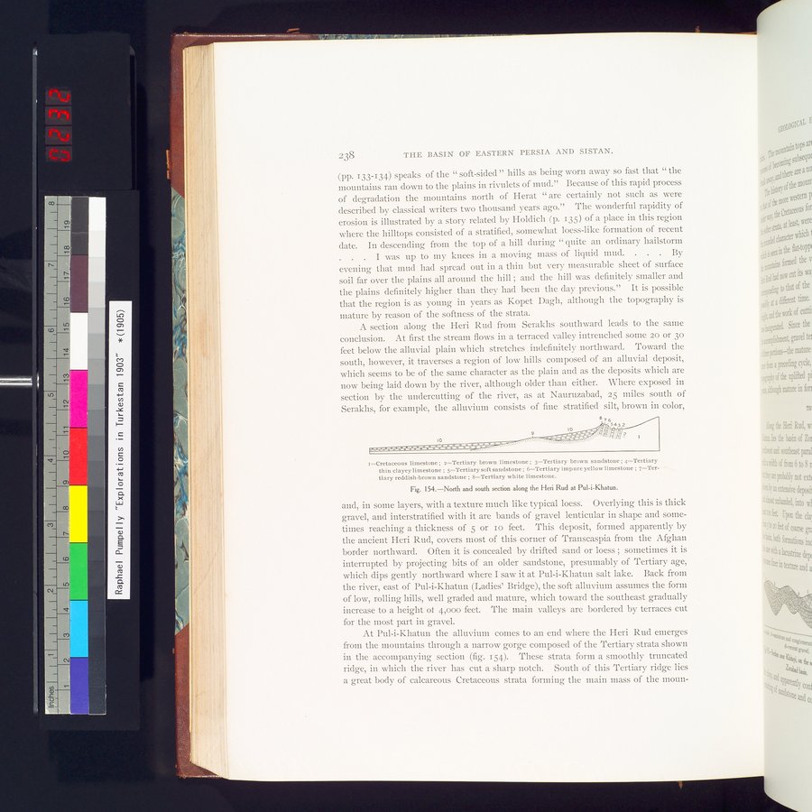
r=Cretaceous limestone ; z=Tertiary brown limestone ; 3—Tertiary brown sandstone ; 4—Tertiary thin clayey limestone ; 5=Tertiary soft sandstone ; 6=Tertiary impure yellow limestone ; 7—Tertiary reddish-brown sandstone ; 8—Tertiary white limestone.
Fig. I54.—North and south section along the Heri Rud at Pul-i-Khatun.
and, in some layers, with a texture much like typical loess. Overlying this is thick gravel, and interstratified with it are bands of gravel lenticular in shape and sometimes reaching a thickness of 5 or io feet. This deposit, formed apparently by the ancient Hen Rud, covers most of this corner of Transcaspia from the Afghan border northward. Often it is concealed by drifted sand or loess ; sometimes it is interrupted by projecting bits of an older sandstone, presumably of Tertiary age, which dips gently northward where I saw it at Pul-i-Khatun salt lake. Back from the river, east of Pul-i-Khatun (Ladies' Bridge), the soft alluvium assumes the form of low, rolling hills, well graded and mature, which toward the southeast gradually increase to a height of 4,000 feet. The main valleys are bordered by terraces cut for the most part in gravel.
At Pul-i-Khatun the alluvium comes to an end where the Heri Rud emerges from the mountains through a narrow gorge composed of the Tertiary strata shown in the accompanying section (fig. 154). These strata form a smoothly truncated ridge, in which the river has cut a sharp notch. South of this Tertiary ridge lies a great body of calcareous Cretaceous strata forming the main mass of the moun-
|
Copyright (C) 2003-2019 National Institute of Informatics and The Toyo Bunko. All Rights Reserved.