National Institute of Informatics - Digital Silk Road Project
| |||||||||
|
| Explorations in Turkestan 1903 : vol.1 |
 |
| 184 | EXPLORATIONS IN TURKESTAN. |
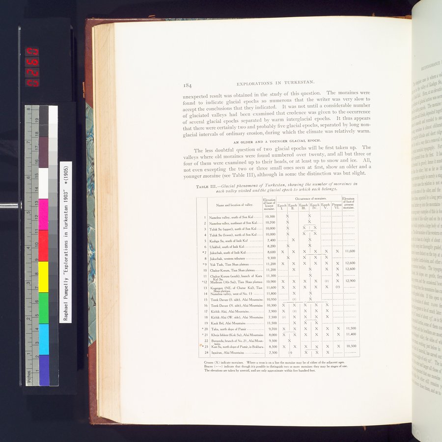
unexpected result was obtained in the study of this question. The moraines were found to indicate glacial epochs so numerous that the writer was very slow to accept the conclusions that they indicated. It was not until a considerable number of glaciated valleys had been examined that credence was given to the occurrence of several glacial epochs separated by warm interglacial epochs. It thus appears that there were certainly two and probably five glacial epochs, separated by long non-glacial intervals of ordinary erosion, during which the climate was relatively warm.
AN OLDER AND A YOUNGER GLACIAL EPOCH.
The less doubtful question of two glacial epochs will be first taken up. The valleys where old moraines were found numbered over twenty, and all but three or four of them were examined up to their heads, or at least up to snow and ice. All, not even excepting the twó or three small ones seen at first, show an older and a younger moraine (see Table III), although in some the distinction was but slight.
TABLE III.—Glacial phenomena of Turkestan, showing the number of moraines in
each valley visited and Use glacial epoch to which each belongs.
Occurrence of moraines.
Elevation
of foot of
Present present VI. moraine.
2
3
4
5
6
s7
8
s9
10
11
*12
13
14
15
16
17
18
19 s 20
* 21
22
As 23
24
| Name and location of valley. | Elevation of base of lowest moraine. |
Nameless valley, south of Son Kul 10,300
Nameless valley, northeast of Son Kul. . . 10,700
Tuluk Su (upper), north of Son Kul . . . 10,000
Tuluk Su (lower), north of Son Kul 10,000
Kashga Su, south of Issik Kul 7,400
Ulakhol, south of Issik Kul 8,200
Jukuchak, south of Issik Kul 8,600
Jukuchak, western tributary 9,300
Yak Tash, Tian Shan plateau 11,200
Chakur Komm, Tian Shan plateau 11,200
Chakur Komm (south), branch of Kara 11,300 Kul Su.
Mudirum (Als Sai), Tian Shan plateau. 10,900
Kogargun (NE. of Chatar Kul), Tian 11,600 Shan plateau.
Nameless valley, west of No. 13 11,800
Terek Davan (S. side). Alai Mountains 10,950
Terek Davan (N. side), Alai Mountains 10,300
Kichik Alai, Alai Mountains 7,900
Kichik Alai (W. side), Alai Mountains 7,500
Kauk Bel, Alai Mountains 11,500
Taka, north slope of Pamir 9,700
Khoja Ishken (Kok Su), Alai Mountains. 8,000
Bursundu, branch of No. 21. Alai Moun- 9,500
tains.
Kan Su, north slope of Pamir, in Bokhara . 8,500
Ispairan, Alai Mountains 7.500
Epoch
X X X X
I X
X
X I X
X
X X
X
X X
X X
X
(?)
~--
X
X (?)
(?) X
X
X X X X X
X X
(?)
Epoch ll.
Epoch I Epoch Epoch
Ill. 11 1V. V.
X
X
r---'-~
X I X
,.___.----,
X I X
X
X
X X X
r--•_=-_,
X X X
X X X
X X
X
X X
X X
X
_ X
X X X X X X
X X
X X X X
X X X I X
(?)
X
X
X X
X X X X
X X X
X X
X
X
X
(?)
11,600
12,600
12,600
12,900
11,500
11,400
10,500
Crosses (X) indicate moraines. Where a cross is on a line the moraine may be of either of the adjacent ages.
Braces indicate that though it is possible to distinguish two or more moraines they may be stages of one.
The elevations are taken by aneroid, and are only approximate within five hundred feet.
|
Copyright (C) 2003-2019 National Institute of Informatics and The Toyo Bunko. All Rights Reserved.