国立情報学研究所 - ディジタル・シルクロード・プロジェクト
| |||||||||
|
| Southern Tibet : vol.8 | |
| 南チベット : vol.8 |
 |
e a
HA-N- HAI(lvort
ight
L.~~
b
úaui- Fü- ;•hzzl ~zieh 'wag (TushlSl act tes)
Yen- tie', ts'ai (rlursoL?~ ke"'
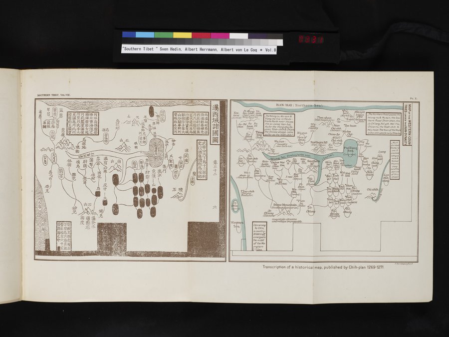
SOUTHERN TIBET, VoL.VIII.
14,I0-14-fif7tS li Nl~-~M -111 131 4sCMe---iff 1 A NATiF~titkt*li' k 4 *4 t~.y~~~k~ ~? ~ ~ O~~~ ~~,-y{{,~,~~~~,~j i~ ~ )C~ ~ll~l.; , tIf
',I.-A.4'4
PL. X.
Transcription of a historical map, published by Chih-p`an 1269-1271
The Northern Road passes the Hsiung-nu& Wusun, the Southern Road Shan-shan, the Jo Ch'iang, Hsi yeh, Wei-t'ou, Chuan-tu, the Yüeh-chih & Hsi u-hsün. The town of the Hope in Chü-shih cal/ed forme -/y Chiao-ho.
r~
Kiang
t0 the eQSt
z1E
L
(Parthr~
~
(B
North (Tien-
i
a[7rt¢.
a-
~I.
TheHsiung-nu, Wu-sun & K'ang-chi) live in the extreme North near the sea, the so-ca/led Hon-hai. As for the ffanq-chu. Tayüan, Yüeh- chih & Chi pi the Chinese envoys came as far as the Yüeh-chih."
Ao- Chi Su- Fu- chien hsieh uzi
(Sag/
a;~
.
~ • ~ ~
(P ~~ )
(Fe 1
Wu-sun, Tqi oqf
t
~
Nan)
-tut
(ToksutE)
~/~ \/\/^\Su
(Tfaslwar)
Wu-i-
shan-
(AlazArachosia)
*T £en-
Mowl.t~a.in. ~ ~arakorunts
V`Te ey~ S a r
Wu-sun
rr ortrtt1 earlssik kill)
~ li-
TSen-shan
(Döss megen/ora) ~-~~~hih?Ns~
/ ~(
~ 6 ú ~~r. *Tan-huan
country ~ Chü-shiic ~~
~Bsiv2sar) llct-t'cvt
Chiao-ho/'~~—
/
So- Wetz-
liszu P`u- chi~ -su South
~
Chiiavz Wei- Iz gt) Writ)
(AÜiE ~ ( - t.O
111Ìt-
XSL Walt)
, •, •) Nan- I--nai Yek I,
tint 4r u_ ^ ( /Tar
~8 ~~
(s
To- - Chiang (Thetans
ii mountain-streams
andvalleys impassable.
Concerning Ta Chin, a country. 10000/iof ,' emergedin the midst cf the We-
tern
HSea.
„ We-ti divided ísempi r into 13 provin' withgove norsec formed the prey. Liang outofthe district of Chiu ch íien':
shara
nWu- (GúnLe)
Tj -chi& hehr)
4 Nerrmannfccit
|
Copyright (C) 2003-2019
National Institute of Informatics(国立情報学研究所)
and
The Toyo Bunko(東洋文庫). All Rights Reserved.
本ウェブサイトに掲載するデジタル文化資源の無断転載は固くお断りいたします。