 IIIF Color HighRes
National Institute of Informatics - Digital Silk Road Project
| |||||||||
|
| IIIF Color HighRes |
| Southern Tibet : vol.7 |
 |
 |
 |
 |
 |
 |
|
|
 |
|
|
|
|
|
|
|
|
Citation Information
522
nearly the same as the distance from the eastern shore of Tso-nyak to the point of 47,5 m. But in the case of the Indus valley the gradient is more than twice
as steep, or 1°8 m.
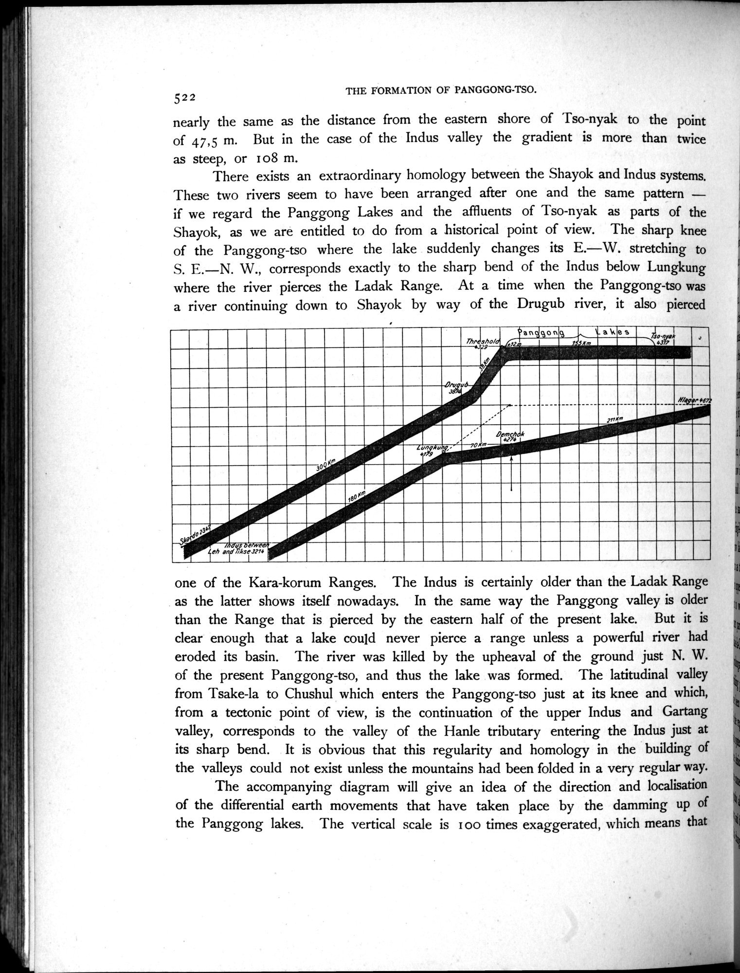
There exists an extraordinary homology between the Shayok and Indus systems. These two rivers seem to have been arranged after one and the same pattern — if we regard the Panggong Lakes and the affluents of Tso-nyak as parts of the Shayok, as we are entitled to do from a historical point of view. The sharp knee of the Panggong-tso where the lake suddenly changes its E.—W. stretching to S. E.—N. W., corresponds exactly to the sharp bend of the Indus below Lungkung where the river pierces the Ladak Range. At a time when the Panggong-tso was a river continuing down to Shayok by way of the Drugub river, it also pierced
THE FORMATION OF PANGGONG-TSO.
11
one of the Kara-korum Ranges. The Indus is certainly older than the Ladak Range as the latter shows itself nowadays. In the same way the Panggong valley is older than the Range that is pierced by the eastern half of the present lake. But it is clear enough that a lake could never pierce a range unless a powerful river had eroded its basin. The river was killed by the upheaval of the ground just N. W. of the present Panggong-tso, and thus the lake was formed. The latitudinal valley from Tsake-la to Chushul which enters the Panggong-tso just at its knee and which, from a tectonic point of view, is the continuation of the upper Indus and Gartang valley, corresponds to the valley of the Hanle tributary entering the Indus just at its sharp bend. It is obvious that this regularity and homology in the building of the valleys could not exist unless the mountains had been folded in a very regular way.
The accompanying diagram will give an idea of the direction and localisation of the differential earth movements that have taken place by the damming up of the Panggong lakes. The vertical scale is I oo times exaggerated, which means that
/ndus %ehwee.
Leh and 71kse3774
1
|
|
|
|
|
|
|
|
|
Copyright (C) 2003-2019 National Institute of Informatics and The Toyo Bunko. All Rights Reserved.