国立情報学研究所 - ディジタル・シルクロード・プロジェクト
| |||||||||
|
| Southern Tibet : vol.3 | |
| 南チベット : vol.3 |
 |
THE FOURTH CROSSING.
If
3O8
to the east, which is said to be more comfortable, though it crosses the double threshold Shalung-la, 5,32o m high; between the two passes is the valley Shalunglungpa, a tributary to Gyägong, or, as it is called lower down, Kyungtsang. From Shalung-la the Chomo-uchong again presents a beautiful view, and now, when seen from the north, the mountain group does not look like a knot or accumulation of peaks, but like a real, sharp range with several peaks in a line. In this perspective it became clearer than before that the Chomo-uchong is a link between Lunpogangri and the comparatively low range which is situated between the Raga-tsangpo and the Tsangpo.
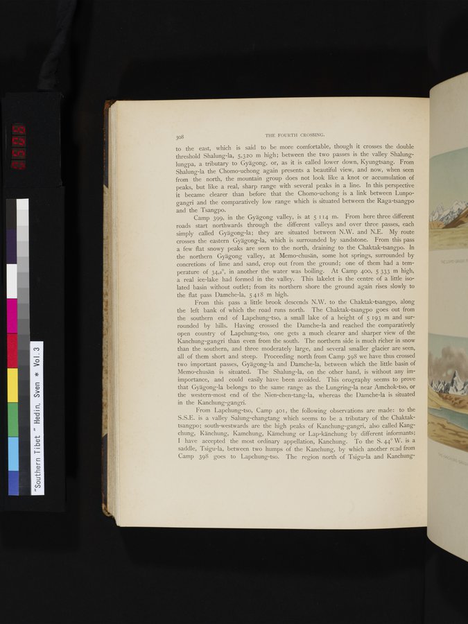
Camp 399, in the Gyägong valley, is at 5 114 m. From here three different roads start northwards through the different valleys and over three passes, each simply called Gyägong-la; they are situated between N.W. and N.E. My route crosses the eastern Gyägong-la, which is surrounded by sandstone. From this pass a few flat snowy peaks are seen to the north, draining to the Chaktak-tsangpo. In the northern Gyägong valley, at Memo-chusän, some hot springs, surrounded by concretions of lime and sand, crop out from the ground ; one of them had a ternperature of 34,2°, in another the water was boiling. At Camp 400, 5 333 m high, a real ice-lake had formed in the valley. This lakelet is the centre of a little isolated basin without outlet; from its northern shore the ground again rises slowly to the flat pass Damche-la, 5 418 m high.
From this pass a little brook descends N.W. to the Chaktak-tsangpo, along the left bank of which the road runs north. The Chaktak-tsangpo goes out from the southern end of Lapchung-tso, a small lake of a height of 5 193 m and surrounded by hills. Having crossed the Damche-la and reached the comparatively open country of Lapchung-tso, one gets a much clearer and sharper view of the Kanchung-gangri than even from the south. The northern side is much richer in snow than the southern, and three moderately large, and several smaller glacier are seen, all of them short and steep. Proceeding north from Camp J98 we have thus crossed two important passes, Gyägong-la and Damche-la, between which the little basin of Memo-chusän is situated. The Shalung-la, on the other hand, is without any im-importance, and could easily have been avoided. This orography seems to prove that Gyägong-la belongs to the same range as the Lungring-la near Amchok-tso, or the western-most end of the Nien-chen-tang-la, whereas the Damche-la is situated in the Kanchung-gangri.
From Lapchung-tso, Camp 401, the following observations are made: to the S.S.E. is a valley Salung-changtang which seems to be a tributary of the Chaktaktsangpo ; south-westwards are the high peaks of Kanchung-gangri, also called Kangchung, Känchung, Kamchung, Kämchung or Lap-känchung by different informants; I have accepted the most ordinary appellation, Kanchung. To the S. 44° W. is a saddle, Tsigu-la, between two humps of the Kanchung, by which another read from Camp 398 goes to Lapchung-tso. The region north of Tsigu-la and Kanchung-
|
Copyright (C) 2003-2019
National Institute of Informatics(国立情報学研究所)
and
The Toyo Bunko(東洋文庫). All Rights Reserved.
本ウェブサイトに掲載するデジタル文化資源の無断転載は固くお断りいたします。