国立情報学研究所 - ディジタル・シルクロード・プロジェクト
| |||||||||
|
| Scientific Results of a Journey in Central Asia, 1899-1902 : vol.3 | |
| 1899-1902年の中央アジア旅行における科学的成果 : vol.3 |
 |
NORTH AND WEST OF THE ANAMBARUIN-ULA. 385
this being a language I am not master of. On the other hand I had no guide 'along the southern foot of the mountains, and the attempt to allocate names there from Särtäng or from the northern route did not prove feasible ; consequently I have only entered one or two which appeared to me to be sufficiently trustworthy. The same remarks apply to a number of names west of the Anambaruin-gol; these too I am unable to enter upon my map, although they prove that the Mongols possess names for the glens and passes in the eastern Astin-tagh, at any rate as far west of the Anambaruin-gol as their migrations extend. Thus the Hong-lu-gu is said to be the name of a small glen situated east of the little pass of Schi-lang-to; Littledale calls it Kong Lugu. Schinne-kötel is a pass in the southern range east of Ja-ma-tschan, across which a track leads to Särtäng. Sa-lang-tsä is the name of a place where gold is found immediately east of Ku-schui-cha, where occur sand-dunes, bound together by vegetation. Hu-du-so is reported to be the name of a district in the eastern Astin-tagh, and the southern range there is known as Tsagan-ula,
while the mountains south of Sa-tscheo are called Nan-sän (Nan-schan). The spring which, on the authority of my Mussulman guides, I have called above Ja-ma-tschan, was called by the Mongols Ja-ma-tschuen-tsa.
d
( ~
\ ° ~\ ,. ~,_.._~-~'
(( -~ t,...... _, .,- ~
r ~_ ~-~ ^•~~~ { ~•r~ \~,r
((( ,1
~ ~ rch Idörel ~~ f ~ ( \ ;
.~"-•~..y~_ 1~r~ (`( ~)r1 (` r~ ~ ~, 1 i~, r~l(
: "\~\!\~ r((~~~'(~ (f.~~ r~ 1
( \~ (~'(`(~~( ~
N` t ( I I çç ; `
(f (r~1(~~; ,~\l ll
(r (( r\ l'' ~
, ~/ (~/
~~~~,~ l)(~j(.~~1~~'1!
~.
~ ~~~ (((( ti, ~I ((( ~( ,,~ '
(( ~ ,'~ !r. (((`: ) ~l(I
((l(~ <<°~ ~
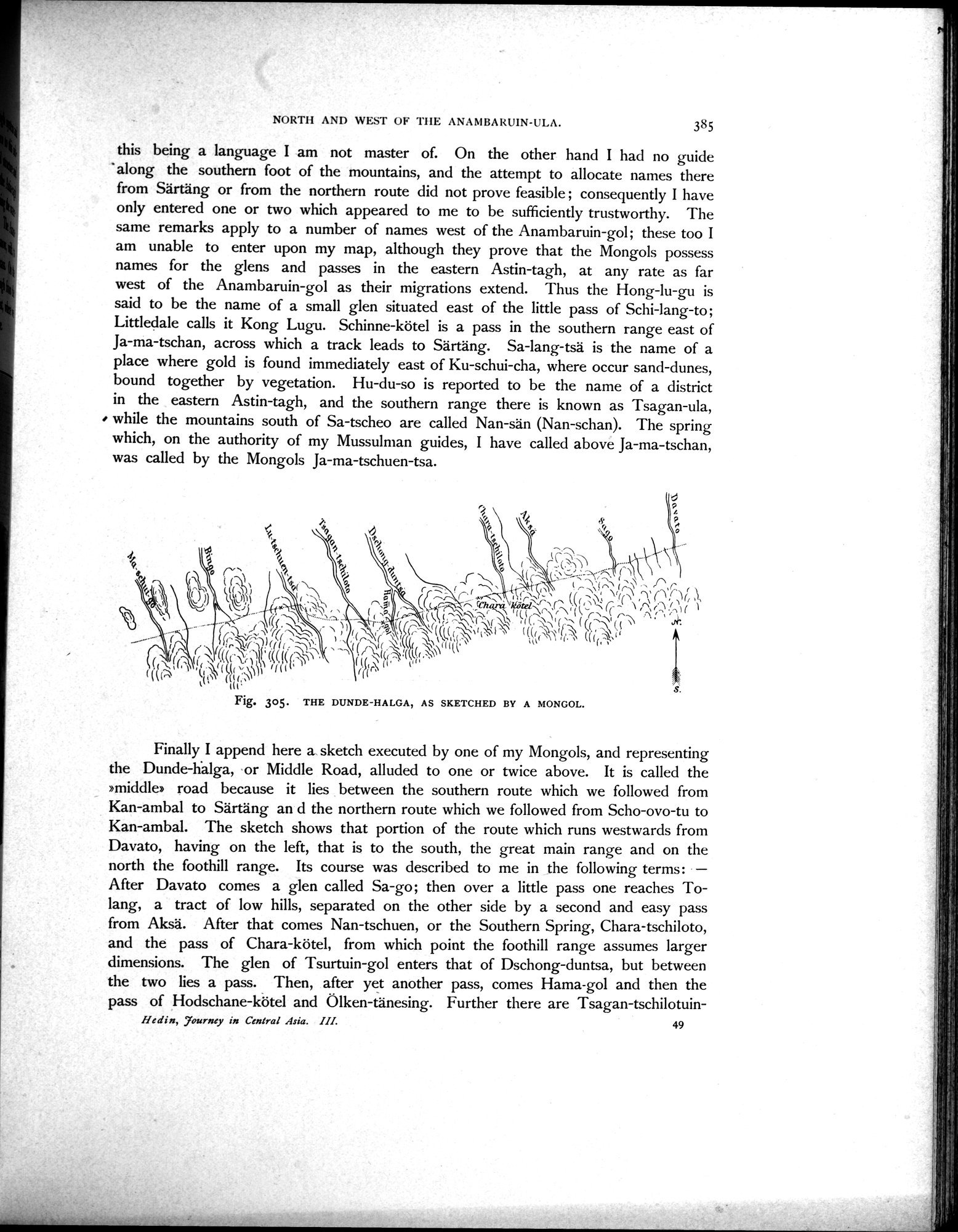
Fig. 305. THE DUNDE-HALGA,
AS SKETCHED BY A MONGOL.
Finally I append here a sketch executed by one of my Mongols, and representing the Dunde-halga, or Middle Road, alluded to one or twice above. It is called the »middle» road because it lies between the southern route which we followed from Kan-ambal to Särtäng an d the northern route which we followed from Scho-ovo-tu to Kan-ambal. The sketch shows that portion of the route which runs westwards from Davato, having on the left, that is to the south, the great main range and on the north the foothill range. Its course was described to me in the following terms : — After Davato comes a glen called Sa-go ; then over a little pass one reaches To-lang, a tract of low hills, separated on the other side by a second and easy pass from Aksä. After that comes Nan-tschuen, or the Southern Spring, Chara-tschiloto, and the pass of Chara-kötel, from which point the foothill range assumes larger dimensions. The glen of Tsurtuin-gol enters that of Dschong-duntsa, but between the two lies a pass. Then, after yet another pass, comes Hama-gol and then the pass of Hodschane-kötel and Ölken-tänesing. Further there are Tsagan-tschilotuin-
Hedin, Tourney in Central Asia. III. 49
|
Copyright (C) 2003-2019
National Institute of Informatics(国立情報学研究所)
and
The Toyo Bunko(東洋文庫). All Rights Reserved.
本ウェブサイトに掲載するデジタル文化資源の無断転載は固くお断りいたします。