国立情報学研究所 - ディジタル・シルクロード・プロジェクト
| |||||||||
|
| Southern Tibet : vol.4 | |
| 南チベット : vol.4 |
 |
FROM GARTOK TO THE JUNCTION WITH THE SINGI-KAMBA.
182
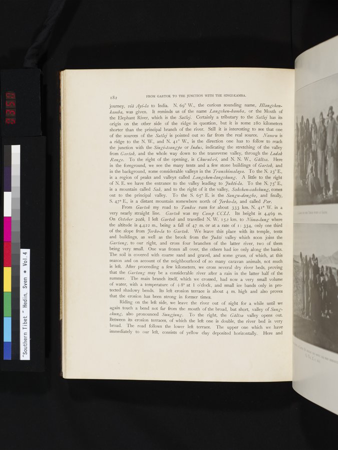
journey, viâ Ayi-la to India. N. 69° W., the curious sounding name, Hlangchenkantba, was given. It reminds us of the name Langchen-kantba, or the Mouth of the Elephant River, which is the Satlej. Certainly a tributary to the Satlej has its origin on the other side of the ridge in question, but it is some 28o kilometers shorter than the principal branch of the river. Still it is interesting to see that one of the sources of the Satlej is pointed out so far from the real source. Nantru is a ridge to the N. W., and N. 41° W., is the direction one has to follow to reach the junction with the Singi-lsangj5o or Indus, indicating the stretching of the valley from Gartok, and the whole way down to the transverse valley, through the Ladak Range. To the right of the opening, is Churul-ri, and N. N. W., Gältsa. Here in the foreground, we see the many tents and a few stone buildings of Garlok, and in the background, some considerable valleys in the Transhimalaya. To the N. 2 3° E., is a region of peaks and valleys called Langchen-langchung. A little to the right of N. E. we have the entrance to the valley leading to 7ukli-la. To the N. 75° E., is a mountain called Sak, and to the right of it the valley, Sakchen-sakchung, comes out to the principal valley. To the S. 65° E. is the Sangu-dongbo, and finally, S. 47° E., is a distant mountain somewhere north of 7erko-la, and called Par.
From Garlok my road to Tankse runs for about 333 km. N. 41° W. in a very nearly straight line. Garlok was my Camp CCL1. Its height is 4,469 m. On October 201h, I left Garlok and travelled N. W. 15.7 km. to Nima-lung= where the altitude is 4,422 m., being a fall of 47 m. or at a rate of 1: 334, only one third of the slope from 7erko-la to Garlok. We leave this place with its temple, tents and buildings, as well as the brook from the 7ukti valley which soon joins the Gartang, to our right, and cross four branches of the latter river, two of them being very small. One was frozen all over, the others had ice only along the banks. The soil is covered with coarse sand and gravel, and some grass, of which, at this season and on account of the neighbourhood of so many caravan animals, not much is left. After proceeding a few kilometers, we cross several dry river beds, proving that the Gartang may be a considerable river after a rain in the latter half of the summer. The main branch itself, which we crossed, had now a very small volume of water, with a temperature of +8° at 1 o'clock, and small ice bands only in protected shadowy bends. Its left erosion terrace is about 4 m. high and also proves that the erosion has been strong in former times.
Riding on the left side, we leave the river out of sight for a while until we again touch a bend not far from the mouth of the broad, but short, valley of Sung- chung, also pronounced Sungjung . To the right, the Gältsa valley opens out. Between its erosion terraces, of which the left one is double, the river bed is very broad. The road follows the lower left terrace. The upper one which we have immediately to our left, consists of yellow clay deposited horizontally. Here and
|
Copyright (C) 2003-2019
National Institute of Informatics(国立情報学研究所)
and
The Toyo Bunko(東洋文庫). All Rights Reserved.
本ウェブサイトに掲載するデジタル文化資源の無断転載は固くお断りいたします。