国立情報学研究所 - ディジタル・シルクロード・プロジェクト
| |||||||||
|
| Southern Tibet : vol.4 | |
| 南チベット : vol.4 |
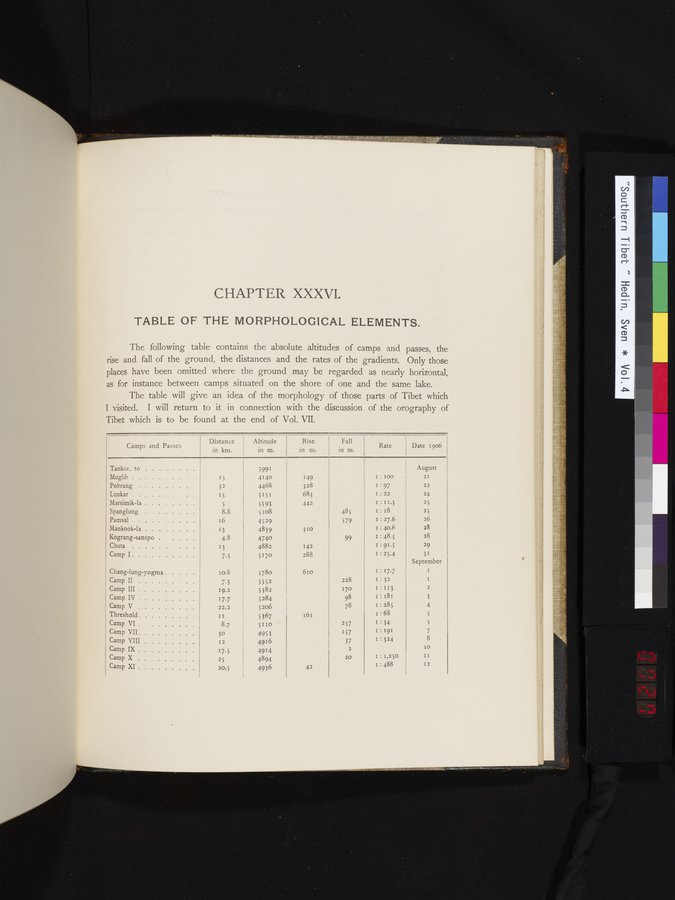 |
CHAPTER XXXVI.
TABLE OF THE MORPHOLOGICAL ELEMENTS.
The following table contains the absolute altitudes of camps and passes, the
rise and fall of the ground, the distances and the rates of the gradients. Only those
places have been omitted where the ground may be regarded as nearly horizontal,
as for instance between camps situated on the shore of one and the same lake.
The table will give an idea of the morphology of those parts of Tibet which
I visited. I will return to it in connection with the discussion of the orography of
Tibet which is to be found at the end of Vol. VII.
|
| • | ||||||
| Camps and Passes | Distance | Altitude in m. | Rise | Fall | Rate | Date 1906 | |
| Tankse, to Muglib Pobrang Lunkar Marsimik-la Spanglung . . Pamsal Mankook-la Kograng-sanspo . . Chuta Camp I Chang-lung-yogma Camp II . .. Camp III Camp IV Camp V Threshold Camp VI Camp VII Camp VIII Camp IX Camp X Camp XI | 15 32 15 5 8.8 16 13 4.8 7.3 Io.8 7.3 19.2 17.7 22.2 II 8.7 3o 12 17.5 25 20.5 | 3991 4140 4468 5151 5593 5 I o8 4529 4839 4740 4882 517o $780 5552 5382 5 284 5206 5367 5110 4953 4916 4914 4894 4936 | 149 328 683 442 310 142 288 610 161 42 | 485 579 99 228 170 98 78 257 157 37 2 20 | I: I00 I : 97 I:22 I : 11.3 I : 18 I : 27.6 I : 40.6 I 48.5 I : 91.5 I : 25.4 I.17•7 I : 32 I : 113 I : 181 1:285 I.68 I.34 I : 191 I.324 I : I,250 I : 488 | August 2I 22 24 25 25 26 28 28 29 31 September I I 2 3 4 5 5 7 8 IO II | |
|
Copyright (C) 2003-2019
National Institute of Informatics(国立情報学研究所)
and
The Toyo Bunko(東洋文庫). All Rights Reserved.
本ウェブサイトに掲載するデジタル文化資源の無断転載は固くお断りいたします。