国立情報学研究所 - ディジタル・シルクロード・プロジェクト
| |||||||||
|
| Southern Tibet : vol.4 | |
| 南チベット : vol.4 |
 |
344 THE SECOND CROSSING OF THE TRANSHIMALAYA.
The next march, on April 12th, continues in a nearly north-westerly direction for 12.6 km. to Camp CXLI or Kating, where the altitude amounts to 4,229 m., 52 m. above Sirchung-, and a rate of 1 : 242, showing still a very slow fall of the Mû-chu valley. In Vol. III , p. 272 there is a photograph of my camp at Kating-, and Pan. 157, Tab. 28, shows the Mu-chu valley continuing N. N. E.
On April 13th, we travelled 16 km. N. N. E and north to Camp CXLII or Ling-a-g-ompa, at an altitude of 4,302 m., or a rise of 73 m. Kating- and Linga both being situated along the river, may be compared directly, the rate is here 1 :219
which is still a very gradual fall. •
Between p. 272 and p. 273, Vol. III, there are some sketches from Linga and
other places in the neighbourhood. Between p. 2 74 and p. 275 there are three photographs of Linga-g'om pa. Pan. 163, Tab. 3o, is a view of the bridge across the right, or western, tributary Lenjo, with the Mü-chu valley to the right. Pan. 167, Tab. 3o, is taken from Linga gompa and gives a view up the valley of Bup-chu, the upper course of which we had passed on the first crossing. In the background due east is the peak Luchen, and along the BV-chu we see the villages of Damochar, Dela and Linga-gyu; between the two rivers is the village of Linga, and in the foreground Mü-chu. Pongra, Tabu and Donglung are mountain regions along the eastern side of the valley, and Kipuk is a little tributary from the same side.
On April 17th, our road takes us 9.6 km. to Camp CXLIII, Langmar
where the altitude is 4,331 m. , or 29 m. above Camp CXLII, the rate being, only I :331. The direction is N. N. W. Pan. 165, Tab. 3o, shows, to the N. 45° W., how very narrow the valley is in this section, and how steep the Donglung tributary is, coming down from the N. 52° E. Pan. 164, Tab. 3o, is taken from Langmar in the direction of our road to the N. W.
On April 18th, we travelled 12 km., N. W. and W. N. W. to Camp CXL VI, Govo. Here the altitude is 4,524 m., 193 m. above Camp CXLIII, and the rate
of ascent as 1:62. The gradient is, therefore, much steeper than hitherto. If we consider only the 8 km. from Camp CXLIII to the junction of the Ke-tsangpo and Pashu-tsangpo, the latter being the upper course of the Mü-chu, the rate becomes still steeper or as 1:44, for at the confluence the altitude is 4,513 m.
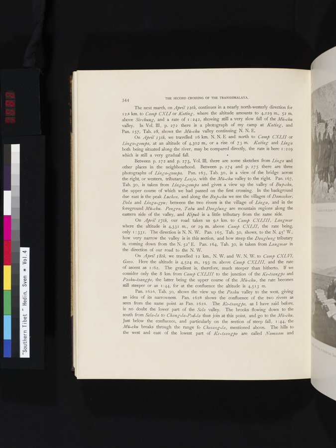
Pan. 162A, Tab. 3o, shows the view up the Pashu valley to the west, giving
an idea of its narrowness. Pan. i6 2 B shows the confluence of the two rivers as seen from the same point as Pan. 162A. The Ke-tsangpo, as I have said before, is no doubt the lower part of the Sela valley. The brooks flowing down to the south from Sela-la to Chang-la-Pod-la thus join at this point, and go to the Mü-chu. Just below the confluence, and particularly on the section of steep fall, I :44, the Mü-chu breaks through the range fo Chesaizg-la, mentioned above. The hills to the west and east of the lowest part of Ke-tsangpo are called Namnam and
i
|
Copyright (C) 2003-2019
National Institute of Informatics(国立情報学研究所)
and
The Toyo Bunko(東洋文庫). All Rights Reserved.
本ウェブサイトに掲載するデジタル文化資源の無断転載は固くお断りいたします。