国立情報学研究所 - ディジタル・シルクロード・プロジェクト
| |||||||||
|
| Southern Tibet : vol.4 | |
| 南チベット : vol.4 |
 |
284
THE REGION WEST OF SHA-KANGSHAM.
flat depression just south of the pass, though its ice-sheet seemed to be formed from springs, to a large extent, and perhaps the »lake» disappears in summer. The path down from the pass, is very steep, so much so, that one prefers to walk on foot. The path leads down to a new latitudinal valley, which, however, is half closed both to the east and west. Sha-kangsham now becomes visible in all its magnificence with eternal snow-fields and glaciers. At the northern edge of the Yum-tso depression, a spring of beautiful fresh water of +1.4° is bubbling up in a hole half a meter across in the sandy ground which, around the hole, was frozen to a depth of 15 cm. The spring forms a minimal brook which goes to the depression and feeds the ice-sheet. The path leads along the eastern shore of the ice, where the shells of small mollusks, especially Planorôis, are very numerous. On the slopes around, old camping places were to be seen everywhere, and to our left, a large flock of sheep was grazing. To our right a big tent was pitched. The ground then becomes undulated, and here and there, snow patches are left. Beyond the undulated ground, we go down to the very flat valley of a river, which was mostly open, and partly covered with thick ice. Its bed was very broad and shallow. To the south it is bounded by red hills. At its northern side, where we pitched our Camp CCCLIX, 4,768 m., was an ice-sheet, resembling a pool, but probably only formed by spring water.
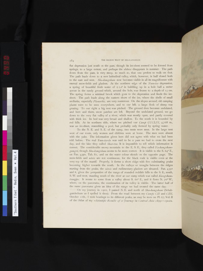
To the N. E. and S. E. of the camp, two tents were seen. In the large tent west of our route, only women and children were at home. The men were absent with the yaks. The information given here did not agree with what we had been told before. The real Y um-tso-la was said to be a pass we had to cross the next day, and the lake they called Shay-tso. It is impossible to tell which information is correct. The considerable snowy mountain to the E. S. E., they called Ya-kangshamgangri, though Sha-kangsham seems to be more correct. It is visible to the S. 64° E., on Pan. 439A, Tab. 81, and on the water colour sketch on the opposite page. The snow-fields and névés are not continuous, for the black rock is visible even at the very top of the massif. Properly, it forms a short ridge with five culminating peaks becoming higher towards the south. In the valleys or troughs between the ridges starting from the peaks, the névés and rudimentary glaciers are situated. Pan. 439A and B, gives the perspective of the range of rounded reddish hills to the S. E., south, S. W. and west, standing south of the river at our camp which was called Kangshamtsangpo. It seems to come from a valley about S. 6o° E., and it flows N. 70° W., where, on the panorama, the continuation of its valley is visible. The latter half of the same panorama gives an idea of the range we had crossed the same day.
On my journey in I 901, I passed N. E. and north of Sha-kangsham (Schahgandschum as I spelled it then). From the road between my Camps CII and VIII, October II th., I took bearings to its different peaks, as may be seen on Pl. 67, Vol. II of the Atlas of my »Scientific Results of a Tourney in Central Asia 1899-1902».
|
Copyright (C) 2003-2019
National Institute of Informatics(国立情報学研究所)
and
The Toyo Bunko(東洋文庫). All Rights Reserved.
本ウェブサイトに掲載するデジタル文化資源の無断転載は固くお断りいたします。