National Institute of Informatics - Digital Silk Road Project
| |||||||||
|
| Scientific Results of a Journey in Central Asia, 1899-1902 : vol.4 |
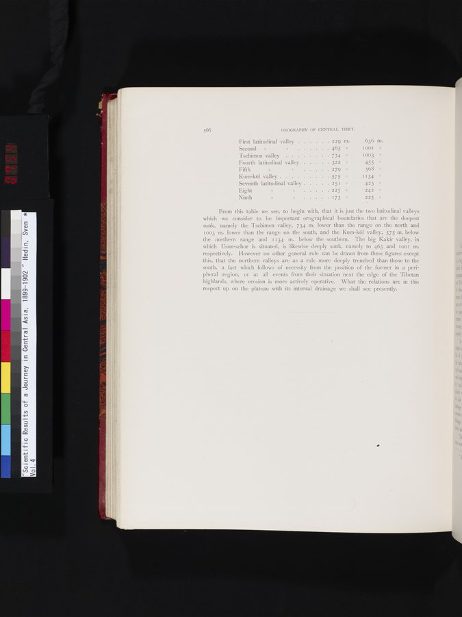 |
566 OROGRAPHY OF CENTRAL TIBET.
,j
| First latitudinal valley Second » » 465 » | 229 m. | 636 m. I001 » | ||
| Tschimen valley | 734 | » | 1 003 | » |
| Fourth latitudinal valley | 322 | » | 455 |
|
| Fifth » .> 279 |
| » | 368 | » |
| Kum-köl valley | 575 | » | 1134 | » |
| Seventh latitudinal valley | 251 | » | 4 23 | » |
| Eight » » 225 |
| » | 242 | » |
| Ninth » » 173 |
| » | 225 | » |
{
From this table we see, to begin with, that it is just the two latitudinal valleys which we consider to be important orographical boundaries that are the deepest sunk, namely the Tschimen valley, 734 m. lower than the range on the north and 1 003 m. lower than the range on the south, and the Kum-köl valley, 575 m. below the northern range and 1134 m. below the southern. The big Kakir valley, in which Usun-schor is situated, is likewise deeply sunk, namely to 465 and I oo m. respectively. However no other general rule can be drawn from these figures except this, that the northern valleys are as a rule more deeply trenched than those to the south, a fact which follows of necessity from the position of the former in a peripheral region, or at all events from their situation next the edge of the Tibetan highlands, where erosion is more actively operative. What the relations are in this respect up on the plateau with its internal drainage we shall see presently.
•
|
Copyright (C) 2003-2019 National Institute of Informatics and The Toyo Bunko. All Rights Reserved.