National Institute of Informatics - Digital Silk Road Project
| |||||||||
|
| Scientific Results of a Journey in Central Asia, 1899-1902 : vol.4 |
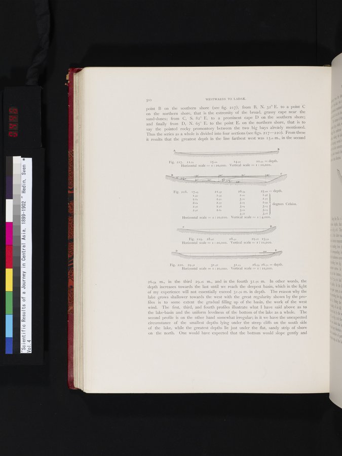 |
310 WESTWARDS TO LADAK.
point B on the southern shore (see fig. 2 17); from B, N. 32° E. to a point C on the northern shore, that is the extremity of the broad, grassy cape near the sand-dunes; from C, S. 82° E. to a prominent cape D on the southern shore; and finally from D, N. 65° E. to the point E. on the northern shore, that is to say the pointed rocky promontory between the two big bays already mentioned. Thus the series as a whole is divided into four sections (see figs. 217-2 zo). From these it results that the greatest depth in the line farthest west was 15.0 m., in the second
Fig. 2I 7. 11.61 15.00 14.50 10.52 = depth.
Horizontal scale = I : 20,000. Vertical scale = I : Io,000.
jf
j,~ $11:
| Fig. 218. | 17.25 | 2 I .37 | 26.54 2 5.2o = depth. | |
|
| I .90 | 1 •35 | 2.00 1.98 |
|
|
| 2 .61 | 2.71 | 3.00 2.7o |
|
|
| 2.62 2.76 | 2.77 2.78 | 3.05 2.99 3.04 3.03 | l degrees Celsius. |
|
| 2.76 | 2.81 | 3..0 3.03 |
|
|
|
|
| 3.28 3.18 |
|
| Horizontal scale = I : 20,000. | Vertical scale = I : 4,000. | |||
Fig. 219. 28.26 28.52 29.16 23.52
Horizontal scale = I : 20,000. Vertical scale = I : I o,000.
Fig. 220. 29.38 31.76 31.13 26.79 26.30 = depth.
Horizontal scale = i : 20,000. Vertical scale = I : 10,000.
410
26.54 m., in the third 29.16 m., and in the fourth 31.76 m. In other words, the depth increases towards the last until we reach the deepest basin, which in the light of my experience will not essentially exceed 31.76 m. in depth. The reason why the lake grows shallower towards the west with the great regularity shown by the profiles is to some extent the gradual filling up of the basin, the work of the west wind. The first, third, and fourth profiles illustrate what I have said above as to the lake-basin and the uniform levelness of the bottom of the lake as a whole. The second profile is on the other hand somewhat irregular; in it we have the unexpected circumstance of the smallest depths lying under the steep cliffs on the south side of the lake, while the greatest depths lie just under the flat, sandy strip of shore on the north. One would have expected that the bottom would slope gently and
|
Copyright (C) 2003-2019 National Institute of Informatics and The Toyo Bunko. All Rights Reserved.