National Institute of Informatics - Digital Silk Road Project
| |||||||||
|
| Scientific Results of a Journey in Central Asia, 1899-1902 : vol.4 |
 |
586 OROGRAPHY OF CENTRAL TIBET.
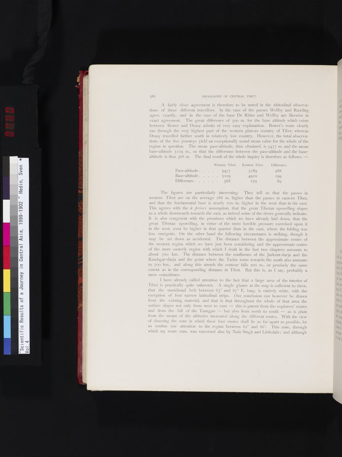
A fairly close agreement is therefore to be noted in the altitudinal observations of these different travellers. In the case of the passes Wellby and Rawling agree exactly, and in the case of the base De Rhins and Wellby are likewise in exact agreement. The great difference of 30o m. for the base altitude which exists between Bower and Deasy admits of very easy explanation. Bower's route clearly ran through the very highest part of the western plateau country of Tibet, whereas Deasy travelled farther south in relatively low country. However, the total observations of the five journeys yield an exceptionally sound mean value for the whole of the region in question. The mean pass-altitude, thus obtained, is 5477 m. and the mean base-altitude 5109 m., so that the difference between the pass-altitude and the base-altitude is thus 368 m. The final result of the whole inquiry is therefore as follows: —
| Western 'Tibet. | Eastern Tibet. | Difference. | |
| Pass-altitude | 5477 | 5 189 | 288 |
| Base-altitude | 5 109 | 4910 | 199 |
| Difference | 368 | 279 | 89 |
The figures are particularly interesting. They tell us that the passes in western Tibet are on the average 288 m. higher than the passes in eastern Tibet, and that the fundamental base is nearly 200 m. higher in the west than in the east. This agrees with the à priori assumption, that the great Tibetan upswelling slopes as a whole downwards towards the east, as indeed some of the rivers generally indicate. It is also congruent with the premisses which we have already laid down, that the great Tibetan upswelling, in virtue of the more forcible pressure exercised upon it in the west, must be higher in that quarter than in the east, where the folding was less energetic. On the other hand the following circumstance is striking, though it may be set down as accidental. The distance between the approximate centre of the western region which we have just been considering and the approximate centre of the more easterly region with which I dealt in the last two chapters amounts to about 700 km. The distance between the confluence of the Jarkent-darja and the Kaschgar-darja and the point where the Tarim turns towards the south also amounts to 700 km., and along this stretch the contour falls 200 m., or precisely the same extent as in the corresponding distance in Tibet. But this is, as I say, probably a mere coincidence.
I have already called attention to the fact that a large area of the interior of Tibet is practically quite unknown. A single glance at the map is sufficient to show, that the meridional belt between 83° and 87° E. long. is entirely white, with the exception of four narrow latitudinal strips. One conclusion can however be drawn from the existing material, and that is that throughout the whole of that area the surface slopes not only from west to east — this is patent from the explorers' routes and from the fall of the Tsangpo — but also from north to south — as is plain from the means of the altitudes measured along the different routes. With the view of choosing the zone in which these four routes shall lie as far apart as possible, let us confine our attention to the region between 82° and 86°. This zone, through which my route runs, was traversed also by Nain Singh and Littledale; and although
|
Copyright (C) 2003-2019 National Institute of Informatics and The Toyo Bunko. All Rights Reserved.